Socialist Prishtina: The tale of unfinished urbanization
Florina Jerliu
Fig.
1 - Sequence from the former Marshal Tito Street, before and after
demolition of the 16th century Lokaq Mosque and the construction of the
Hotel Bozur (later Hotel Iliria). The modernist hotel
“Iliria” was privatized in 2006 and soon was destructed to
make space for a new hotel Swiss Diamond. (Photo source: Municipality
of Prishtina Photo Archive).
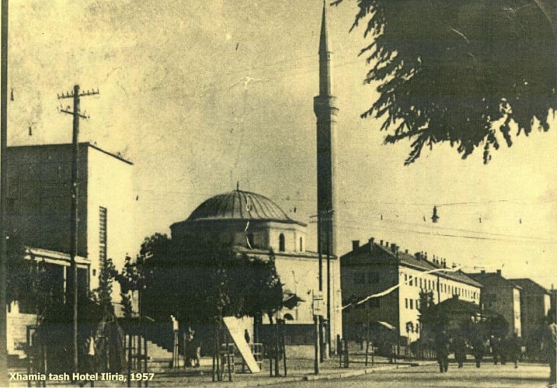
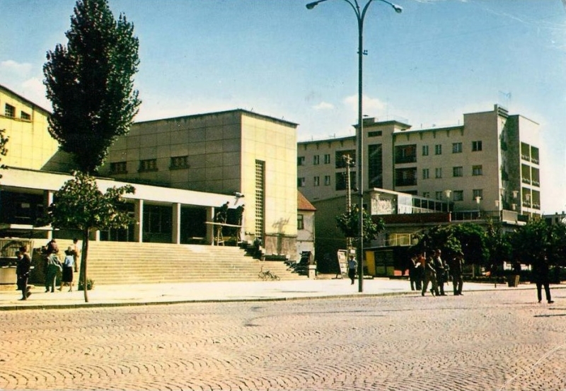
Fig.
2 - Sequence from the modern city center, showing the mode of
unfinished task of socialist urbanization (Photo excerpt from Google
Earth 2022, drawing by the author).
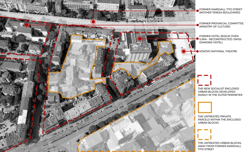
Fig.
3 - DUP for the Historic Core: existing situation (left), proposed
layout (right). [Figure-base: Urbanisticki Zavod Opstine Prishtina,
1979; drawing by author].
Fig.
4a - Modern architecture in Prishtina. a) Ulpiana neighborhood built in
1960s in free land; one, if not the only example of successful planning
implementations. (photo source: facebook community page 'Prishtina e
Vjetër' in: https://web.facebook.com/PrishtinaOLD/ (accessed
7.12.2017).
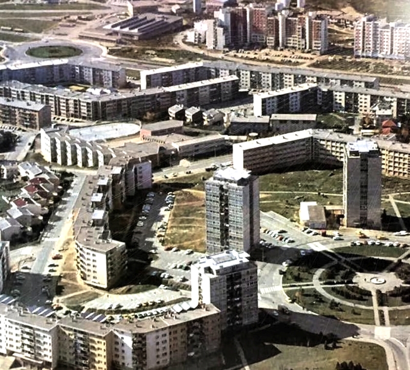
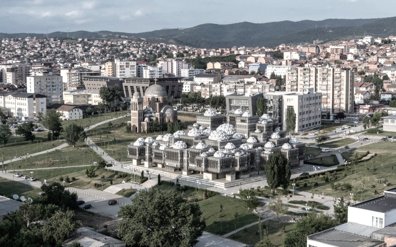
Fig.
4b - Modern architecture in Prishtina. b) National Library; until late
2004 the surrounding of the library was deserted. Greening and few
paths were introduced latter to enable access from the university
buildings located in the near vicinity. (photo source: facebook
community page 'Prishtina e Vjetër' in:
https://web.facebook.com/PrishtinaOLD/ (accessed 7.12.2017).
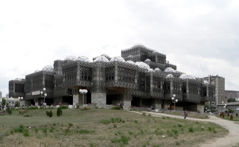
Fig.
4c - Modern architecture in Prishtina. c) National Library; until late
2004 the surrounding of the library was deserted. Greening and few
paths were introduced latter to enable access from the university
buildings located in the near vicinity. (photo source: facebook
community page 'Prishtina e Vjetër' in:
https://web.facebook.com/PrishtinaOLD/ (accessed 7.12.2017).
Fig.
5 - Map of Prishtina Urban Plan 2000, 1987.

Introduction
Prishtina, the capital of the Republic of Kosovo, once the center
of the Vilayet of Kosovo (before the fall of the Ottoman Empire), was
the capital of the Province of Kosovo within ex-Yugoslavia. It used to
be a typical Ottoman city, with a compact urban structure and an
identifiable nucleus, the Old Bazaar. Neighborhoods were evenly
distributed around the Bazaar and, as in other Ottoman cities, they
maintained a superb distinction between public and private realms
(Pasic 2004, p.7). Throughout the late 1940s and 1960s, the Bazaar was
razed to the ground by the socialist regime, making way for the new
city center. This symbolic space was chosen to set the scene for the
new Yugoslavian representation of Kosovo, emerging in the form of the
Brotherhood and Unity Square, and two state institutions on either side
of the square: the Municipal Assembly Building and the building of the
Regional People’s Committee for Kosovo (today the Parliament of
Kosovo). The socialist urbanization of Prishtina replicates such
patterns of ideological interventions in the rest of the existing city
structure.
De-Ottomanization of the capital city meant not only becoming
Yugoslav and modern, but also maintaining an inferior identity of
Kosovo Albanians within the federation (Le Normand, p. 258; Malcolm
1998, p. 314). The planned destruction of a large proportion of the
traditional architecture justified on the ground of liquidating the
backwardness of the Ottoman city (Mitrovic1953, pp. 165-166), [1] was based not on genuine urban
plans as commonly witnessed in other ex-Yugoslav cities, but rather on
so-called «urban activities», a term coined by socialist
planners to describe the actions that were «necessary for
preparing a study on the development of Prishtina» (Jovanovic
1965). Throughout the socialist period, studies, plans, and
«urban activities», were carried out simultaneously,
sometimes independently, yet often left incomplete. Thus, fragmented
intervention as an output, and unfinished urbanization as a process,
became the most distinct legacy of city’s modernization.
There is a small body of documentation regarding the urban
development of Prishtina during socialism, although in recent times the
number of publications on the architecture of the period has increased
significantly, [2] along with the
awareness of its preservation. However, the gap of knowledge persists
on the context of state and urban policies that gave shape to the city
development, and this is identified and addressed briefly in this
contribution. I argue that shedding light to the interplay of planning
decisions and activities on the ground, both chronologically and
thematically, helps to understand certain aspects of implementation of
urban policies, which were in line with state policies of the
ex-Yugoslavia, while complementary to the specific policy of Serbia in
Kosovo. Therefore, this study mainly relies on and analyzes the
official and archival documents of the period, with the belief that
they are rather overlooked by the scholars, while in fact they comprise
an important source on the context and contents of planning. In this
regard, few relevant quotes are brought in full, which in hand
illustrate the official language and overall ethos of the time, and
fill-in the larger picture of the mode of urbanization in socialist
Prishtina.
Laying the Foundations of the New Socialist City
In the aftermath of the Second World War, among major undertakings
in ex-Yugoslavia was to lay the foundations for new modern socialist
cities, and this was made clear through various official documents and
statements, as illustrated in the quote below:
[...] Prishtina abandoned its former characteristics, and has
grown, and is growing into a modern city; its physiognomy is
fundamentally changing, it is transforming with an unprecedented rhythm
and is erasing all what identified it with a remote
‘kasaba’ [town] (Zikic 1959, p.24) [...] it is leaving its
past behind and is becoming a modern city – a new socialist
city’ (Cukic e Mekuli 1965, p.12).
This journey in Prishtina commenced in 1947, marked by the
transformation of the primary south-north artery (previously known as
Lokaq street) into a modernist boulevard, purposed to accommodate newly
established state institutions; and was renamed into Marshal Tito
Street. The initial modern structure to rise along its eastern front
was the Provincial Committee (today the Ministry of Culture),
sequentially accompanied by other institutions, such as the National
Theatre, the National Bank, and the Municipality of Prishtina, among
others (Jovanovic, B. 1965). By 1953, the street transformation came
almost to its end.
The Marshal Tito Street project required massive demolitions; beside
the Old Bazaar, formerly located at the northern end of the axis, a
large portion of traditional architecture including historic buildings
(a catholic church and a mosque), were razed to the ground (Jerliu, F
and Navakazi, V. 2018) (Fig. 1). It is noteworthy to highlight that
this transformation occurred well prior to the adoption of the Detailed
Urban Plan (DUP) for the city center in 1967 (Pecanin).
The «retroactive planning» of the city center, as
understood from the quote below, was implemented to alleviate the
challenge of finishing the planned urban blocks. They were partially
developed to house new institutions, but private parcels within the
envisioned enclosed urban block typology, were left untreated. Even
today, they are spaces filled with private houses: a pre-socialist
cadaster awaiting to be regularized (Fig.2).
This plan was partially implemented for the needs of the
administration of the Province, the Municipality and other public
facilities... The realization of these spaces destroyed the old Bazaar
and a large number of facilities in the surrounding environment. Other
contents cannot be realized due to the existing housing, and this plan
should be put out of force. (ibid)
In a way, the plan was designed with the expectation of being phased
out, which reveals the overarching intention of the socialist regime:
to construct the facade of the Marshall Tito Street rather than to
urbanize the city center to the benefit of residents, being in majority
Albanians (Jerliu and Navakazi 2018).
Socialist Urban Planning: “Loading…”
A milestone date in the city development is 1953. This is the year
identified among other as the beginnings of a large-scale deportation
of Kosovo Albanians, as part of the treaty signed between ex-Yugoslavia
and Turkey. The so-called «Gentleman's Agreement» reached
in January 1953 between Tito and the Turkish foreign Minister Khiprili
requested that Yugoslavia fulfils the 1938 Convention, according to
which about one million inhabitants were to be settled in vacant
regions of Turkey. Between 1945 and 1966, known as the
«Rankovic’s Era»[3],
roughly 246,000 were deported to Turkey from the whole ex-Yugoslavia of
which 100,000 people (mainly Albanians) from Kosovo alone (Malcolm
1998, p. 323).
This process had a profound impact on Prishtina, both
demographically and economically: most of the investments during this
period were concentrated in the capital-investment, rather than
labor-investment. Also, investments were made in primary industry such
as in mines, power stations, and basic chemical works, a sector that
was intended to supply Kosovo’s raw materials and energy for use
elsewhere in Yugoslavia. (Malcolm 1998, pp. 322-324).
The year 1953 is also symbolic for the beginnings of urban plans in
Prishtina. It is the year of adoption of the Urban General Plan
for Prishtina 1950-1980, drafted by Iskra from Belgrade
under the leadership of Dragutin Partonjic. The plan foresaw the city
growth from 24,081[4] to 50.000
inhabitants and surface from 223.04 Ha to 950 Ha. While information on
the technicalities of the plan is briefly revealed in a later Prishtina
Urban Plan 2000 (PUP 2000), a report from 1953 Gradovi i
Naselja… provides the substance of the plan. Given that the
language used in this report is rather self-explanatory, hence the
quoted vision:
The geopolitical position of the city, its role in the economy of
the country (ex-Yugoslavia], especially of its wider region, the
changes in social conditions, the relatively rich economic hinterland,
the inherited primitive and materially poor construction of heritage,
and other factors, impose the need, in solving the urbanization
problems of Prishtina, for a general reconstruction of the existing
situation, not only of the city but also its immediate surroundings.
Based on the analysis of established current and possible objective
conditions, the future development program for the next 20 years
envisions Prishtina with an increased population of 50,000 and an
economic character as a poorly developed industrial city, with
predominantly processing industries employing 8-10% of the population.
The guidelines of the program had to inevitably reflect in the basic
framework of the regulatory plan. The applied type of urban
reconstruction anticipates the acquisition of free territories and
radical measures for the rearrangement of the built-up area, with
maximum utilization of inherited values. (Mitrovic 1953, p. 166)
Based on this rather unambitious vision, the new city borders were
set. Extensive reconstructions took place in the inner-city while
vastly disregarding its built heritage, and the southern outskirts
developed into new modernist neighborhoods. However, within a decade,
the city's population had reached the envisioned figure of 50,000
inhabitants,[5] therefore, a
decision was made to expand the
city boundaries from 950 hectares as planned in 1953, to 1950 hectares
(Cukic and Mekuli 1965, p.36). Interestingly, PUP 2000 disclosed that
no material evidence on urban plans for the following development phase
were found in the premises of the Municipality of Prishtina:
Judging by the note that this space was planned for 107 954
inhabitants until 1980, this could have been the amended Prishtina
Urban Plan [alluding to Partonjic 1953 Plan], for which no traces of
documentation exist. [So] In 1965 arch. Nikola Dobrovic began the
drafting of the “Directive Plan for Traffic and Land Use for the
city”, which was completed and approved in 1967. The plan was
drafted for 100,000 inhabitants and surface of 1950.00 hectares. From
documentation, only the graphic annex of land use exists (S: 2500). In
1969 the decision was made that the “Directive Plan for Traffic
and Land Use for the city” is replaced by the General Urban Plan
for Prishtina, by which the Plan of 1953 ceased to be in force.
(Municipality of Prishtina 1987, p.11)
As the quote reveals, throughout 1960s-1970s, there was a process of
planning for a new “general” plan. In meantime, as of 1965,
and well beyond until mid-1980s, urban development in Prishtina
continued its pace on the basis of smaller plans, namely, Detail Urban
Plans (DUPs), which according to the planning officials:
«… [were] based on the Decision that replaces the General
Urban Plan from 1966, and more recently on the General Plan of
Prishtina» (Pecanin). Regardless the confusions
deriving from this statement as to which plan substitutes or is
substituted by a certain decision or plan, or whether generally existed
any General Urban plan, DUPs were made for various sizes of space and
contents, ranging from large-scale neighborhoods to small housing
areas, be it built-up areas scheduled for demolition or free land, from
large to small complexes of housing and public buildings; there were
even DUPs for individual buildings too[6].
According to
archival data, between 1967 and 1986 a total of 34 DUPs were drafted;
by 1990, majority of DUPs were partially implemented and only a small
number of them were in fact fully realized (Pecanin).
Another victim of «retroactive planning» was the
Historic Core. The Detailed Urban Plan (DUP) for the Historic Core was
approved in 1979, which is over 30 years after systematic and planned
destruction of Prishtina’s urban built heritage. Although in
principle DUP should have intended to protect the survived heritage,
its highlight was the planning for a massive commercial building of
18,600 sqm, occupying circa 60% of the total planned newly built area.
This superstructure foresaw to amalgamate the shops which started anew
eastward Bazar’s area after its destruction: the Bazar's second
life was beginning, and the regime went after this one too. Spatial
analysis reveals that the plan aimed to preserve roughly 50% of the
existing area, of which 8.6% was roadway, 24.6% green space, and a mere
11.7% existing structures, which included a handful of significant
monuments. The remaining half of the area was earmarked for
reconstruction. (Urbanisticki Zavod Opstine Prishtina, 1979, pp.20-22)
(Fig. 3).
Since its inception, the DUP for the Historic Core was continuously
opposed. In 1987, PUP 2000 introduced new boundaries and conditions for
the preservation of historic area, and by 1990, authorities had also
acknowledged their complete failure in safeguarding city's
pre-socialist past (Pecanin.).
The Promise of Urbanization
During mid-1970s and 1980s, Prishtina benefited the most from the
Yugoslav development fund for underdeveloped regions. (International
Monetary Fund, 1985). A considerable portion of this fund in the urban
development sector was allocated for planning, and to a lesser degree,
for building new state institutions, one of which was the University of
Prishtina, established between 1975 and 1977. The University acted as a
catalyst for large-scale internal migrations to the capital, resulting
in its rapid expansion: between 1971 and 1981, the population
nearly doubled, increasing from 69.514 inhabitants in 1971 to
108.083 inhabitants in 1981. (Municipality of Prishtina 1987, p.5)
During this periuod, Prishtina witnessed substantial growth in its
southwestern area, characterized by the creation of new modernist
neighborhoods, yet, with no foresight for their physical
interconnection. This included the creation of Dardania, Sunny Hill 1,
Sunny Hill 2, and Lakrishte neighborhoods, while Ulpiana neighborhood
had already been built in the late 1960s (Fig. 4.a). Significant
segments of the city's outskirts were also planned through DUPs,
primarily for individual housing, like the Tauk Basce small
neighborhood, Aktash 3, Dragodan hill, among others (Pecanin.). As was
common in other socialist cities, these houses were constructed for the
wealthy and higher-income working-class groups (Szelenyi 1983, p. 63).
Contrastingly, the remainder of the city, particularly its entire
north, was largely overlooked throughout the entire socialist era.
The most significant architectural contribution of this period was
the construction of modernist public buildings. However, similar to the
case of new modern neighborhoods, they often lack integration with
their surroundings, thus creating disjointed spaces. Many public
buildings, like the National Library for instance, failed to shape
cohesive urban quarters due to the unfinished public space in front and
around them (Fig. 4.b). The reasoning behind such an approach might
have been political, as the social utilization of urban space,
especially public gatherings, were perceived as a potential catalyst
for Kosovo Albanians' revolts against the former socialist regime.
The promise for comprehensive urbanization of Prishtina was most
convincingly given by the 'Prishtina Urban Plan 2000' (PUP 2000),
approved in 1987 (Fig.5). This plan, the final one conceived during the
socialist era, remains one of the few official documents that still
serves as a valuable resource in understanding the city's narrative.
PUP 2000 sought to rectify the accumulated spatial and social
discrepancies and challenges. It conceded that Prishtina's development
suffered from a lack of consistent and inclusive planning, which, as it
postulates, led to the formation of three markedly different spatial
entities in the city, each unique in its creation and development: 1)
The neglected and unplanned northern part of the city, typified by poor
living conditions, thus urgently needing improvements; 2) The historic
city center inclusive of new modern buildings, necessitating the
completion of the residential urban infrastructure, with a specific
emphasis on rehabilitating the historic core; and 3) The new modernist
center and southern parts of the city, which began developing from the
1960s onwards, characterized by solid construction and services, but
requiring phased reconstructions and completion (Municipality of
Prishtina 1987, pp. 38-39, 57-59). This categorization endures even
today, attesting to the substantial impact of fragmented and unfinished
process of urbanization of the city.
PUP 2000 also noted that:
[...] the protection and regulation of archaeological sites and
historic nucleus is imperative, since the future of this sector risks
to be left without its past, and the results of creation of
contemporary values risk the abruption of historical and cultural
continuity. (Municipality of Prishtina 1987, p. 172)
Two years later, with the ascension of Milosevic to power in
ex-Yugoslavia, Kosovo entered a terrible phase of state repression that
greatly undermined the comprehensive urbanization improvements as
proposed by PUP 2000. In the present day, Prishtina has developed new
urban plans; however, PUP 2000 - more often being overlooked than
revisited -continues to be vital in genuinely tackling the city’s
challenges rooted in its socialist past.
Conclusion
The tale of socialist Prishtina is one of unfinished
urbanization. Its modernization during the socialist era is intriguing
- especially if juxtaposed with other centers of ex-Yugoslavia - not
only for understanding the nuances of modernist and socialist urban
policies, but also to make sense of what has been inherited from that
era and how it has influenced the city's subsequent development.
Enlightening in this view are the official documents and statements of
the time of socialism; their analyses offer significant insight into
the enduring impact of the political ideology in city's intricate urban
development.
Initially, the Ottoman city had a compact urban structure; it was
deranged in the name of recreating it as a compact modern city, but
this aim was not truly achieved. Instead, the rebuilding process erased
vital fragments of historical tissue, while new development themselves
were left scattered throughout the urban landscape. As a result, the
once compact city became fragmented. Thus, fragmentation is the legacy
inherited from the socialist era, and comprehending its content, along
with the latent potential for its recalibration in line with the
premise of historical continuity, as advocated in current discourse,
proffers a hopeful alternative for the present and future of the city's
modernist legacy, as well as a means of overcoming its "unfinished"
condition.
Notes
[1] The 1953 report on cities
and towns in Serbia defined the existing architecture of the city of
Prishtina as to being remote, and therefore, subject to the so-called
«general radical reconstruction» of the «primitive
appearance and poverty of material and architectural heritage values of
the city»
[2] Some recently published
books on Prishtina are: A; Sylejmani, Sh. (2010). Prishtina ime (My
Prishtina). Java Multimedia production: Prishtina; Hoxha, E. (2012)
Qyteti dhe Dashuria: Ditar Urban - City and Love: Urban Diary, Center
for Humanistic Studies “Gani Bobi” Prishtina; Gjinolli I,
Kabashi, L., Eds. (2015). Kosovo modern: an architectural primer,
National Gallery of Kosovo, Arbër Sadiki (2020) Arkitektura e
Ndërtesave Publike në Prishtinë (Architecture of Public
Buildings in Prishtina), NTG Blendi, Prishtinë, among other.
[3] Aleksandar Rankovic, the
Minister of Interior who was known for directing a harshly
anti-Albanian security policy, was dismissed in 1966.
[4] 24, 081 inhabitants
reflects the figure from the second registration of population carried
out in the same year, 1953, by the socialist regime in ex-Yugoslavia.
[5] This growth is mainly
attributed to the natural growth of the Albanian population in Kosovo,
a feature that characterizes the demography of Kosovo throughout the
20th century. For more information on population growth during the 20th
century see: Statistical Office of Kosovo (2008), Table 2, p.7.
[6] The strategy of
‘fragmented' development through DUPs was observed in
ex-Yugoslavia during the 1960s, as a result of inconsistent execution
of urban plans after the Law on Urban and Regional Planning was enacted
in 1961. (See: Le Normand 2014, p.118.) However, in Prishtina this mode
of development continued throughout the socialist period.
Bibliography
CUKIC D. and MEKULI E. (1965) – The Prishtina Monograph,
Municipality of Prishtina, Prishtina.
Facebook community page Prishtina Ime in:
https://www.facebook.com/groups/620037062517530/ [Last accessed July
2023].
International Monetary Fund (1985) – Yugoslavia and the
World
Bank, available online in:
<https://documents1.worldbank.org/curated/en/295801468305930648/pdf/777760WP0Box370lavia0and0world0bank.pdf>
(Last accessed July 2023)
JERLIU F. e NAVAKAZI V. (2018) – “The Socialist
Modernization of
Prishtina-Interrogating Types of Urban and Architectural Contributions
to the City”. In: Mesto a Dejiny [The City and History]. Vol. 7
(2),
pp. 55-74
JOVANOVIC B. (2011) – “Urbane aktivnosti u
Pristini” Izvestaj, Jun
1965. Urban activities in Prishtina, report, June 1965, retrieved from
the Prishtina Municipality Archive in May.
LE NORMAND B (2014) – Designing Tito’s Capital:
Urban Planning,
Modernism, and Socialism, University of Pittsburgh Press,
Pittsburgh.
MALCOLM N. (1998) – Kosovo. A short History,
Macmillian
Publishers, New York.
MITROVIC M. (1953) – Gradovi i Naselja u Srbiji.
Urbanistički Zavod Narodne Republike Srbije, Beograd.
Municipality of Prishtina (1987) – Prishtina Urban Plan
2000
(PUP 2000), Prishtina.
PASIC A. (2004) – “A Short History of Mostar”. In:
Conservation
and Revitalisation of Historic Mostar, The Aga Khan Trust for
Culture, Geneva
PECANIN S. – Spisak Detaljnih Planova na Teritoriji Grada
Pristine, List of Detailed Plans in the Territory of the City of
Pristina. Archival document, undated. [Retrieved from the Prishtina
Municipality Archive in May 2011].
SZELENYI I. (1983) – Urban Inequalities under State
Socialism,
Oxford, University Press
<https://docs.google.com/spreadsheets/d/1ewZYRfsWz_4HvtIgsUQ5Ws_3NXX__Sm4/edit?usp=sharing&ouid=105977315545044376017&rtpof=true&sd=true>
Statistical Office of Kosovo (2008) – Series 4: Population
Statistics. Demographic changes of the Kosovo population 1948-2006.
Available online:
<https://ask.rks-gov.net/media/1835/demographic-changes-of-the-kosovo-population-1948-2006.pdf>
[Last accessed July 2023].
Urbanisticki Zavod Opstine Prishtina (1979) – Detaljni
Urbanisticki Plan Istorijske Zone Grada sa Zanatskim Centrom
(Urban Plan of the Historical Zone of the City with the Craft Center of
Prishtina) Prishtina.
ZIKIC R. (1959) – The Prishtina Monograph, Prishtina.