Reconstruction and rebirth strategies in post-earthquake
Central Italy: Amatrice, Norcia, Camerino
Tommaso Brighenti
Fig.
1 - Amatrice: photograph taken during the first inspection on October
26, 2017 of the rubble next to the complex designed by Arnaldo
Foschini. Photo by M. Frisinghelli.
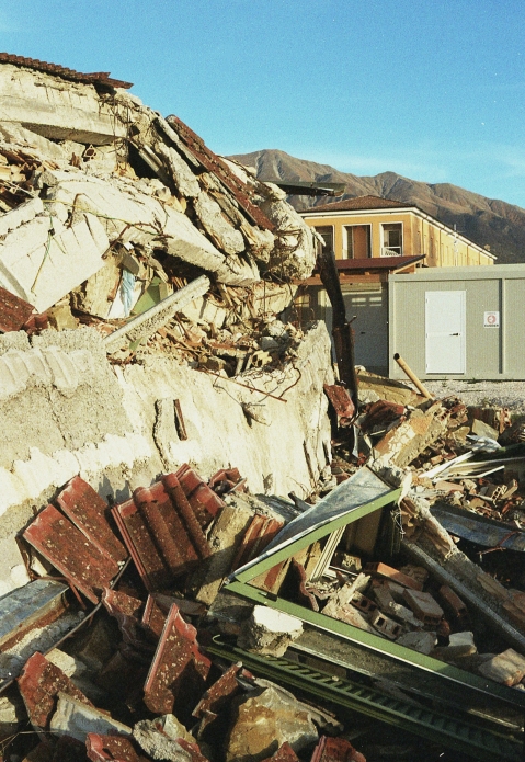
Fig.
2 - Amatrice: “Il nucleo antico di Amatrice:
dov’era,
com’era?”. Planimetry. (Thesis by: L. Bonardi, A.
Valvason;
Supervisors E. Bordogna, T. Brighenti, June 2020; Politecnico di
Milano).
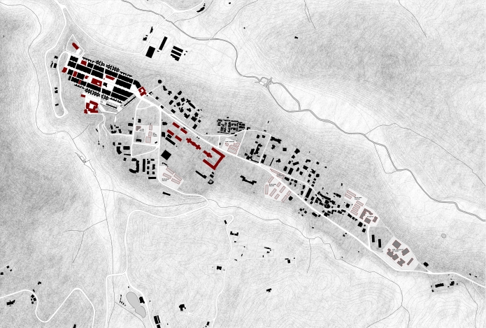
Fig.
3a - Amatrice: “Il nucleo antico di Amatrice:
dov’era,
com’era?”. Ground floor plan of the reconstruction
project
of the historic core. (Thesis by: L. Bonardi, A. Valvason; Supervisors
E. Bordogna, T. Brighenti, June 2020; Politecnico di Milano).
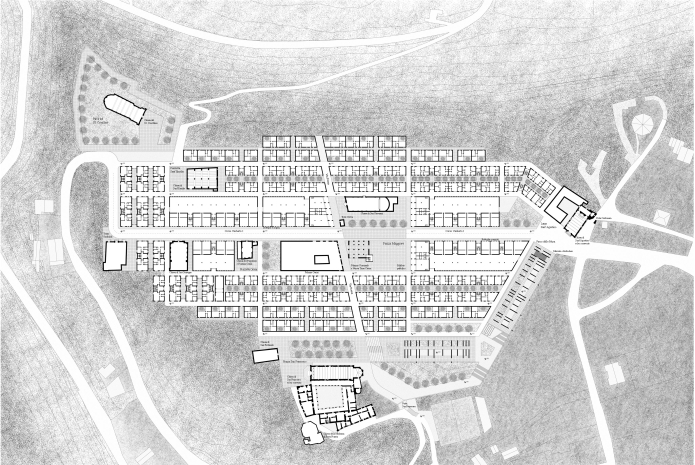
Fig.
3b - Amatrice: “Il nucleo antico di Amatrice:
dov’era,
com’era?”. View from Corso Umberto I of the central
square
with the view of the new broletto and the new civic tower. (Thesis by:
L. Bonardi, A. Valvason; Supervisors E. Bordogna, T. Brighenti, June
2020; Politecnico di Milano).
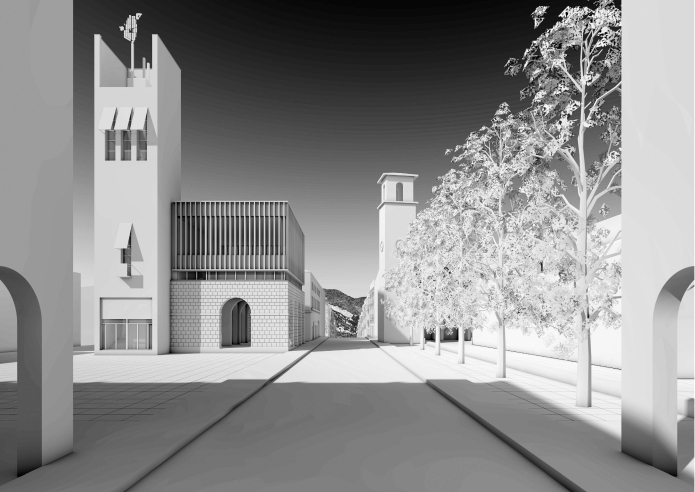
Fig.
3c - Amatrice: “Il nucleo antico di Amatrice:
dov’era,
com’era?”. Reverse view from Corso Umberto I del
Broletto
with the church of Sant’Agostino in the background. (Thesis
by:
L. Bonardi, A. Valvason; Supervisors E. Bordogna, T. Brighenti, June
2020; Politecnico di Milano).
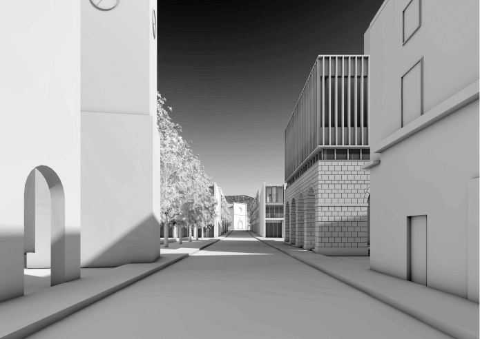
Fig.
4a - Amatrice: “Il nucleo antico di Amatrice:
dov’era,
com’era?”. Axonometric cross-sections of the
typical blocks
of the reconstruction project of the historic core. (Thesis by: L.
Bonardi, A. Valvason; Supervisors E. Bordogna, T. Brighenti, June 2020;
Politecnico di Milano).
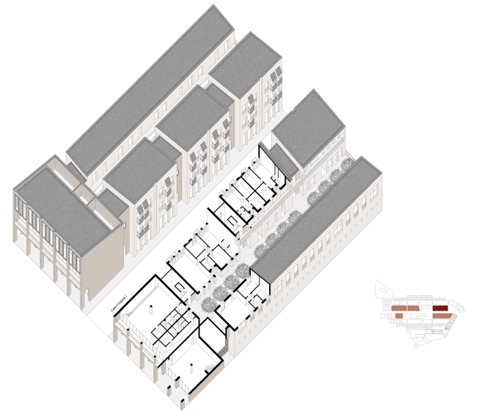
Fig.
4b - Amatrice: “Il nucleo antico di Amatrice:
dov’era,
com’era?”. Axonometric cross-sections of the
typical blocks
of the reconstruction project of the historic core. (Thesis by: L.
Bonardi, A. Valvason; Supervisors E. Bordogna, T. Brighenti, June 2020;
Politecnico di Milano).
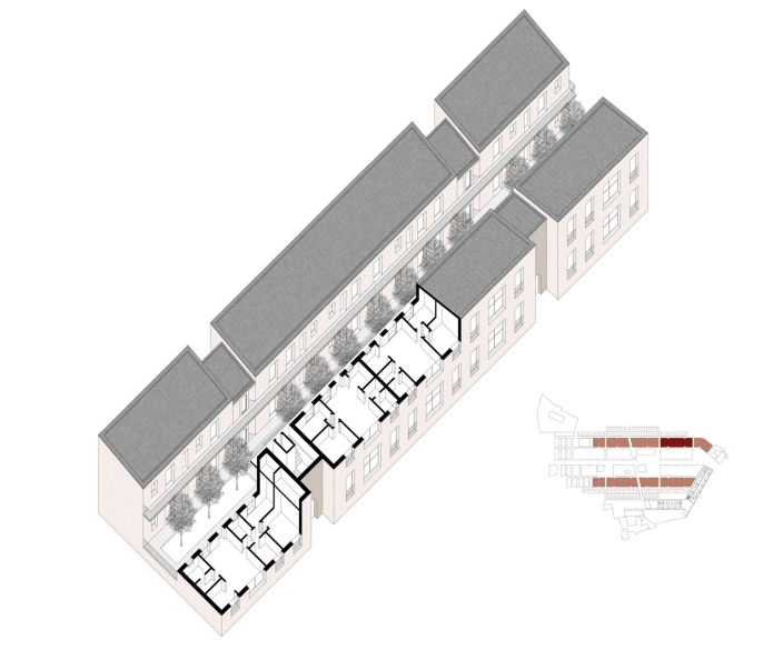
Fig.
4c - Amatrice: “Il nucleo antico di Amatrice:
dov’era,
com’era?”. Axonometric cross-sections of the
typical blocks
of the reconstruction project of the historic core. (Thesis by: L.
Bonardi, A. Valvason; Supervisors E. Bordogna, T. Brighenti, June 2020;
Politecnico di Milano).
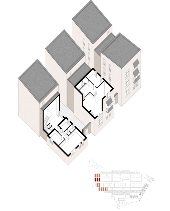
Fig.
4d - Amatrice: “Il nucleo antico di Amatrice:
dov’era,
com’era?”. Axonometric cross-sections of the
typical blocks
of the reconstruction project of the historic core. (Thesis by: L.
Bonardi, A. Valvason; Supervisors E. Bordogna, T. Brighenti, June 2020;
Politecnico di Milano).
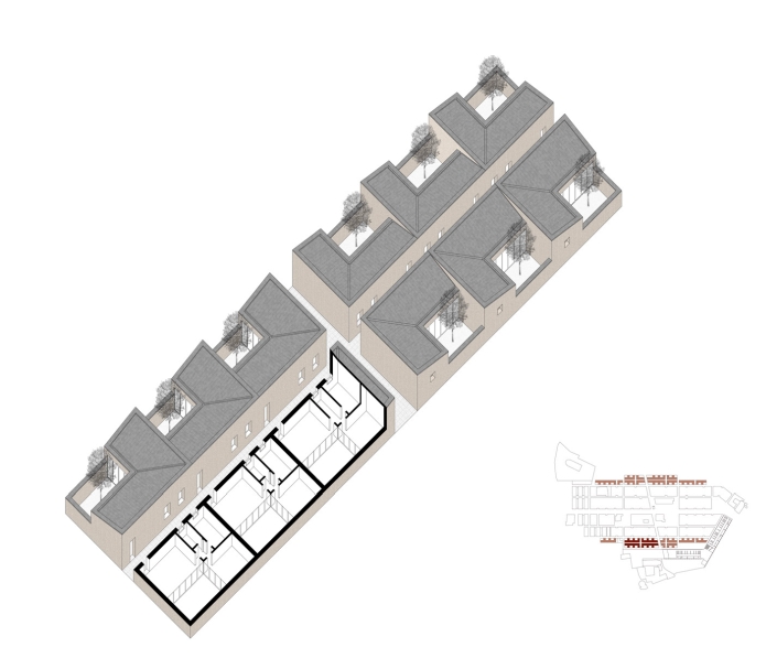
Fig.
5a - Amatrice: reconstruction project of the extra moenia area near the
buildings designed by Arnaldo Foschini. General front view. (Students:
V. Boffo, L. Bongiolatti, A. Bugatti, A. Giamboni, C. Landoni, A.
Sposetti; Prof. E. Bordogna, T. Brighenti; AY 2016-17 and 2017-18;
Politecnico di Milano).
Fig.
5b - Amatrice: reconstruction project of the extra moenia area near the
buildings designed by Arnaldo Foschini. View proposal axonometry.
(Students: V. Boffo, L. Bongiolatti, A. Bugatti, A. Giamboni, C.
Landoni, A. Sposetti; Prof. E. Bordogna, T. Brighenti; AY 2016-17 and
2017-18; Politecnico di Milano).
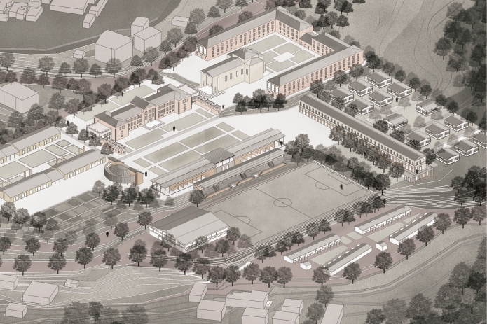
Fig.
5c - Amatrice: reconstruction project of the extra moenia area near the
buildings designed by Arnaldo Foschini. Drawings of the
“anatomical theater”: plans, elevation and section.
(Students: V. Boffo, L. Bongiolatti, A. Bugatti, A. Giamboni, C.
Landoni, A. Sposetti; Prof. E. Bordogna, T. Brighenti; AY 2016-17 and
2017-18; Politecnico di Milano).
Fig.
5c - Amatrice: reconstruction project of the extra moenia area near the
buildings designed by Arnaldo Foschini. Drawings of the
“anatomical theater”: plans, elevation and section.
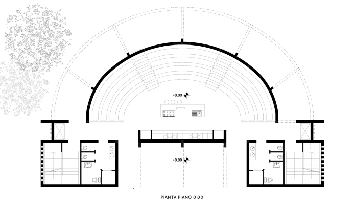
Fig.
5c - Amatrice: reconstruction project of the extra moenia area near the
buildings designed by Arnaldo Foschini. Drawings of the
“anatomical theater”: plans, elevation and section.
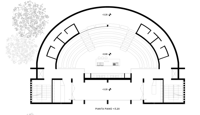
Fig.
5c - Amatrice: reconstruction project of the extra moenia area near the
buildings designed by Arnaldo Foschini. Drawings of the
“anatomical theater”: plans, elevation and section.
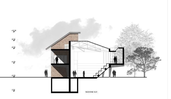
Fig.
6a-b - Norcia: Primary School. General plan. (Students: S. Angeli, S.
Angrilli; Prof. E. Bordogna, T. Brighenti; AY 2018-19; Politecnico di
Milano).
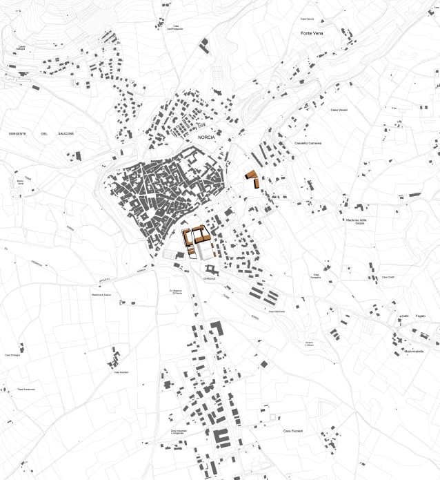
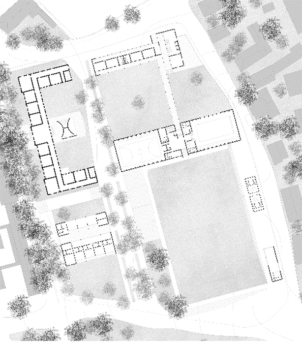
Fig.
6c - Norcia: Primary School. Ground floor plan. (Students: S. Angeli,
S. Angrilli; Prof. E. Bordogna, T. Brighenti; AY 2018-19; Politecnico
di Milano).
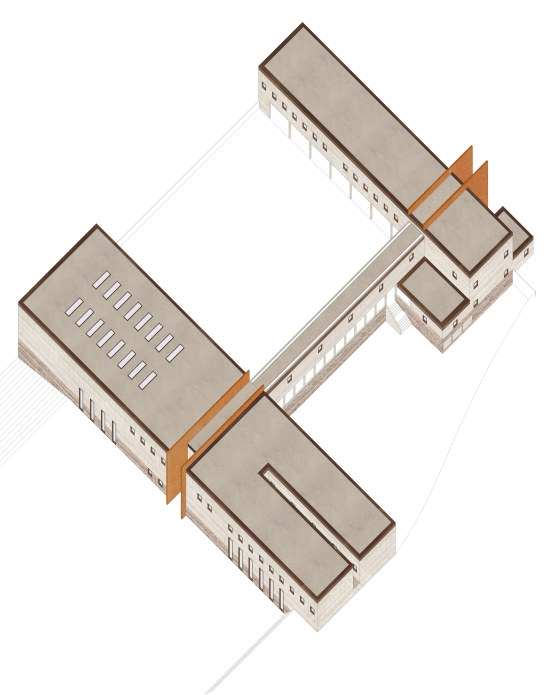
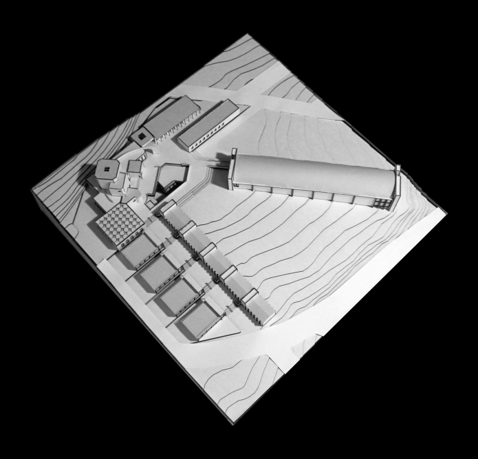
Fig.
6d - Norcia: Primary School. Phisical Model. (Students: S. Angeli, S.
Angrilli; Prof. E. Bordogna, T. Brighenti; AY 2018-19; Politecnico di
Milano).
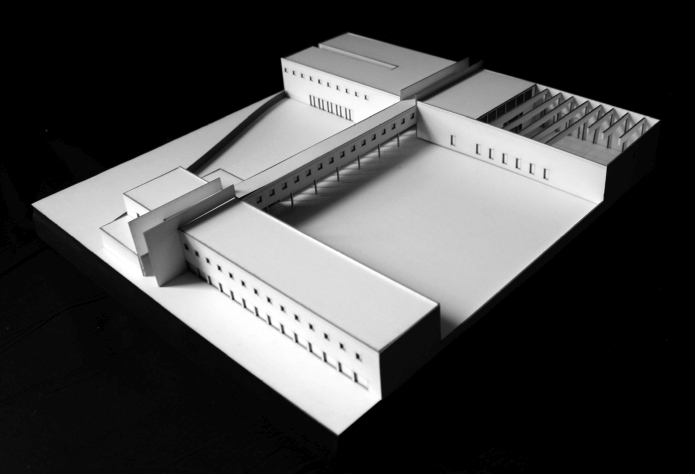
Fig.
7a-b - Norcia: school complex for Primary School. Volumetric plan;
Ground floor plan; Model of the school complex to the north and model
of the school complex along the route of access; View of the school
complex from the valley. (Students: M. Colombo, P. Escoriza, M. Iotti;
Prof. E. Bordogna, T. Brighenti; AY 2018-19; Politecnico di Milano).
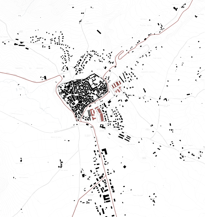
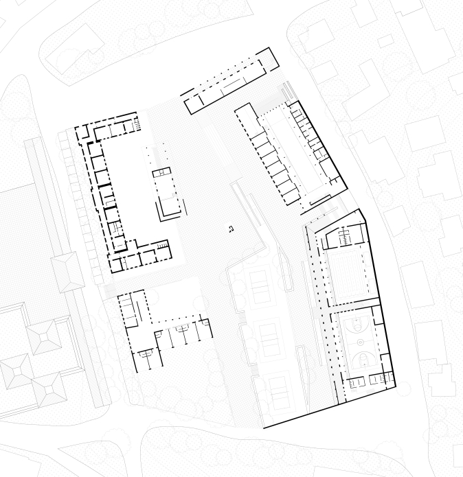
Fig.
7c - Norcia: school complex for Primary School. Volumetric plan; Ground
floor plan; Model of the school complex to the north and model of the
school complex along the route of access; View of the school complex
from the valley. (Students: M. Colombo, P. Escoriza, M. Iotti; Prof. E.
Bordogna, T. Brighenti; AY 2018-19; Politecnico di Milano).
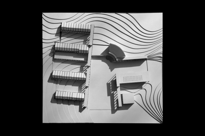
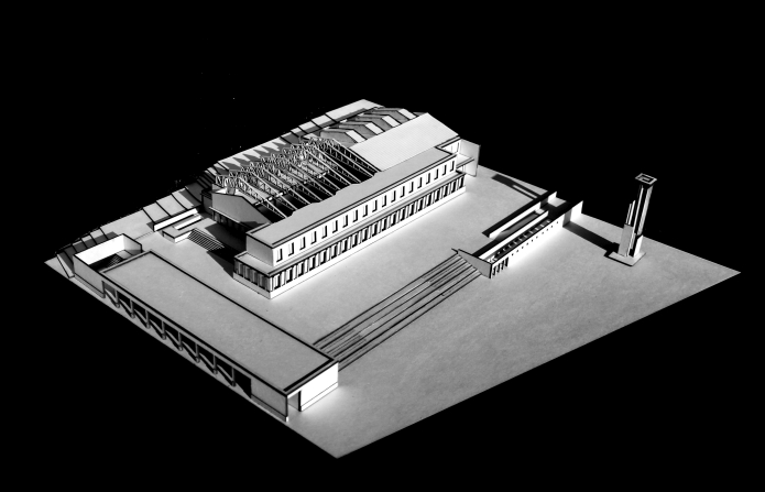
Fig.
7d - Norcia: school complex for Primary School. Volumetric plan; Ground
floor plan; Model of the school complex to the north and model of the
school complex along the route of access; View of the school complex
from the valley. (Students: M. Colombo, P. Escoriza, M. Iotti; Prof. E.
Bordogna, T. Brighenti; AY 2018-19; Politecnico di Milano).
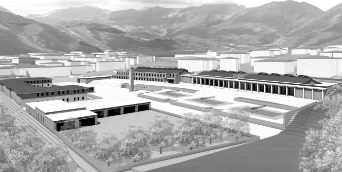
Fig.
8a - Norcia: Exhibition center and treet market. Street market
elevations prospects; Axonometric view of the exhibition halls and
market; Volumetric plan. (Students: V. Boffo, L. Bongiolatti, A.
Bugatti, A. Giamboni, C. Landoni, A. Sposetti; Prof. E. Bordogna, T.
Brighenti; AY 2016-17 and 2017-18; Politecnico di Milano).
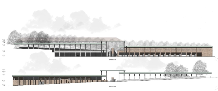
Fig.
8b - Norcia: Exhibition center and treet market. Street market
elevations prospects; Axonometric view of the exhibition halls and
market; Volumetric plan. (Students: V. Boffo, L. Bongiolatti, A.
Bugatti, A. Giamboni, C. Landoni, A. Sposetti; Prof. E. Bordogna, T.
Brighenti; AY 2016-17 and 2017-18; Politecnico di Milano).
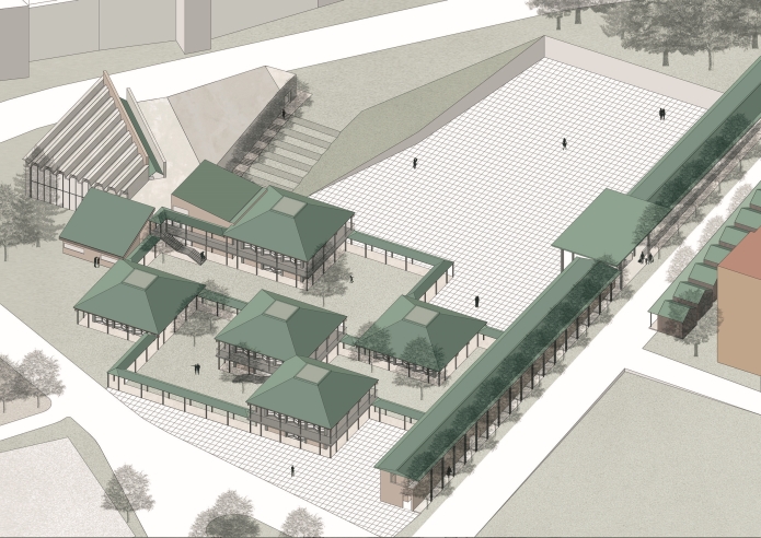
Fig.
8c - Norcia: Exhibition center and treet market. Street market
elevations prospects; Axonometric view of the exhibition halls and
market; Volumetric plan. (Students: V. Boffo, L. Bongiolatti, A.
Bugatti, A. Giamboni, C. Landoni, A. Sposetti; Prof. E. Bordogna, T.
Brighenti; AY 2016-17 and 2017-18; Politecnico di Milano).
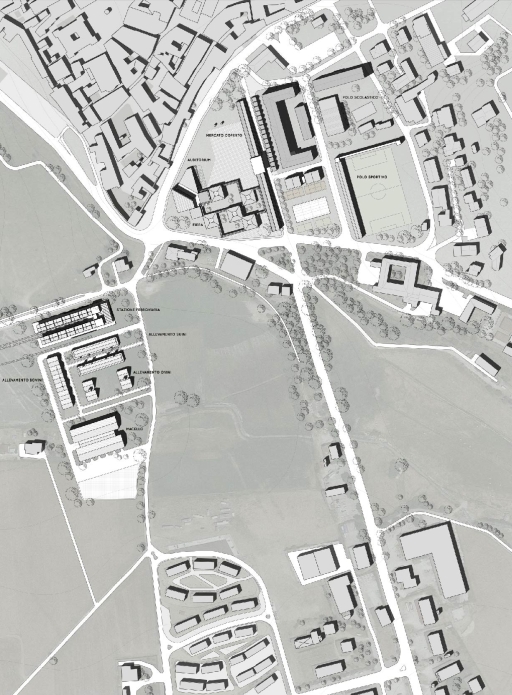
Fig.
9 - Camerino: center for the recovery, shelter and restoration of works
of art affected by the earthquake. Planimetry. (Thesis by: S. Faravelli
and M. Frisinghelli; Supervisors: E. Bordogna, T. Brighenti, AY
2017/18; Politecnico di Milano).
Fig.
10a - Camerino: center for the recovery, shelter and restoration of
works of art affected by the earthquake. Elevation; Basement floor
plan; Ground floor plan; General axonometry. (Thesis by: S. Faravelli
and M. Frisinghelli; Supervisors: E. Bordogna, T. Brighenti; AY
2017/18; Politecnico di Milano).
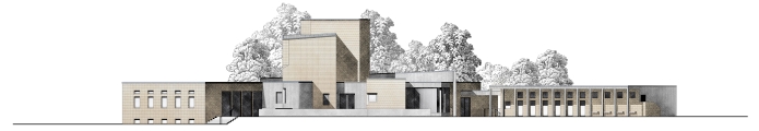
Fig.
10b - Camerino: center for the recovery, shelter and restoration of
works of art affected by the earthquake. Elevation; Basement floor
plan; Ground floor plan; General axonometry. (Thesis by: S. Faravelli
and M. Frisinghelli; Supervisors: E. Bordogna, T. Brighenti; AY
2017/18; Politecnico di Milano).
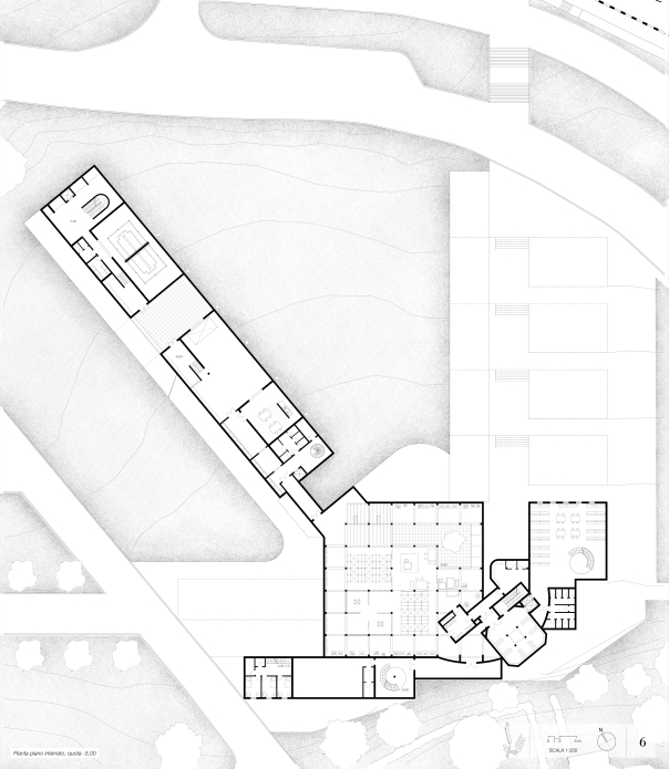
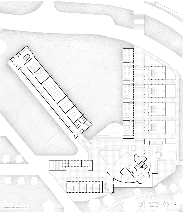
Fig.
10c - Camerino: center for the recovery, shelter and restoration of
works of art affected by the earthquake. Elevation; Basement floor
plan; Ground floor plan; General axonometry. (Thesis by: S. Faravelli
and M. Frisinghelli; Supervisors: E. Bordogna, T. Brighenti; AY
2017/18; Politecnico di Milano).
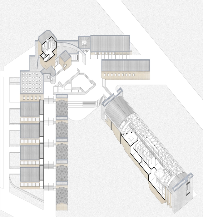
Fig.
10d - Camerino: center for the recovery, shelter and restoration of
works of art affected by the earthquake. Elevation; Basement floor
plan; Ground floor plan; General axonometry. (Thesis by: S. Faravelli
and M. Frisinghelli; Supervisors: E. Bordogna, T. Brighenti; AY
2017/18; Politecnico di Milano).
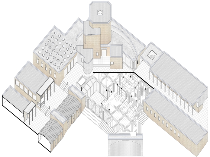
Fig.
10d - Camerino: center for the recovery, shelter and restoration of
works of art affected by the earthquake. Elevation; Basement floor
plan; Ground floor plan; General axonometry. (Thesis by: S. Faravelli
and M. Frisinghelli; Supervisors: E. Bordogna, T. Brighenti; AY
2017/18; Politecnico di Milano).
In line with a long case history of earthquakes in Italy (Messina 1908;
Belice 1968; Friuli 1976; L’Aquila 2009; Romagna 2012), also the
earthquake which struck the territories of Central Italy in the
summer-autumn of 2016 caused damage on many different fronts: to
monuments, the urban residential fabric, scattered private buildings,
production facilities, education and service systems, the
infrastructure system, and the road access networks.
In all of these sectors, beyond the non-negligible and indispensable
distinction between the moment of the emergency, to be tackled with
immediate reversible interventions, and that of reconstruction, which,
on the contrary, requires structural and prospectively stable
interventions aimed at restoring and relaunching the form and life of
the towns and territories affected, the reconstruction strategy can be,
and often has been, addressed not only “in terms of pure
reparation, but also with virtual intentions of innovation and a
relaunch that differs according to the situation” (Canella 1978)[1], in line with a targeted strategy which, once again, differs on a case-by-case, context-by-context basis.
In regard to the earthquake in Central Italy of 2016, and
restricting the field to the municipalities of Norcia, Amatrice and
Camerino, the diagnostic analyses and the reconstruction strategies
were necessarily different. By means of various projects, and a
dialectic interaction on the various realities, we tried out different
reconstruction strategies that could develop new driving forces,
distinguished according to the specific settlement, historical and
structural characteristics of the contexts in question, and fittingly
identifying multiple intervention strategies.
If, in Amatrice[2], drastically
affected by the earthquake, so much so that practically nothing remains
of the ancient nucleus, the reconstruction of the outlying areas can
only proceed properly by taking into account certain significant
pre-existing buildings such as the civic complex built by Arnaldo
Foschini, the most urgent complaint seems to be that of the integral
reconstitution of the historical nucleus and of all those civic and
residence services located in the Old Town; in Norcia[3],
apart from the monumental buildings in the centre for which a
philological restoration is conceivable, the most urgent sector for
reactivation and relaunch seems to be that of the widespread fabric of
small production and commercial units linked to the agri-food sector,
together with elementary and secondary education facilities, hard hit
by the earthquake; in Camerino[4]
it seems that a possible intervention cannot ignore the historic
university and cultural structures present, while addressing the
recovery, safeguarding and restoration of works of art affected by the
earthquake, also in consideration of the presence of some courses
linked to the local cultural heritage and the historic University.
The historical nucleus of Amatrice: where it was, as it was?[5]
Among the municipalities affected by the 2016 earthquake in Central
Italy, Amatrice is patently among the most severely damaged, a fact
which has triggered a heated debate over the reconstruction strategy to
be adopted (Fig. 1). Any intervention on the ancient nucleus will be
extremely complex, given the condition of a genuine clean slate, with
the almost complete elimination of the built fabric but the same
original morphology as the ancient pre-earthquake centre. Currently,
only the central road axis remains recognizable, which structured this
typical ridge settlement diagonally from gate to gate, west to east.
In this context, the strategy adopted aims at confirming the
perimeter area of the ancient nucleus by way of a morphological layout
faithful to the original settlement, with a longitudinal conformation
arranged on a northwest-southeast axis, and a road network based on an
orthogonal grid with a straight main axis and two crossroads. The
pattern of the blocks is re-proposed to conform with the existing
fabric through “a system inscribed within an almost rectangular
perimeter, according to characteristics not dissimilar to the tradition
of the Florentine “New Lands” (see the example of Arnolfo
di Cambio’s San Giovanni Valdarno) or to contemporary
“foundation cities” in the French Midi.” (Bordogna
2019)[6]. (Figg. 2-3a).
With this project, we wished to investigate two intervention themes developed on an architectural scale.
The theme of the first project concerned certain civic structures
and the configuration of a series of public spaces. In particular, in a
central position with respect to the urban grid thus defined, the
project envisages a partially porticoed square, located on the northern
side of the main axis, the current Corso Umberto I, and proposes a
complete reconstruction of the Church of San Giovanni along with the
conservation and valorization of the Civic Tower, which is among the
few buildings not destroyed by the earthquake. On the opposite side of
the street, is the Palazzo del Comune – the Town Hall, a building
which adopts the typological tradition of the broletto or
mercantile loggia, porticoed on all side on the ground floor to recover
and reconstruct the original base dating back to the medieval period;
on the floors above are office spaces, available to the Municipality of
Amatrice, and a large council room/civic hall for exhibitions,
conferences, and recreational events. The various floors are accessible
thanks to a tower located at one of the corners of the volume,
envisaged as a new civic tower, a figurative and symbolic element which
recalls the turreted appearance of the medieval town as well as
becoming a symbol of the reconstruction (Figg. 3b-c).
The second theme concerns the residential fabric, with three blocks
to be flexibly adopted in the reconstruction process as needed: this
block type becomes two further variants depending on whether it is
standing on the main street (with three storeys above ground) or on the
side streets (two storeys above ground) structured internally with a
central stairwell which gives access to two apartments per floor which
overlook the street (Figg. 4 a-b); a terraced type (with one or two
storeys) which has a configuration of two buildings separated
longitudinally by an internal garden (Fig. 4c); or a patio type, a
single-storey suitable for the outermost blocks of the town, consisting
in a series of dwelling units characterized by an internal roadway and
views mainly of the internal patio (Fig. 4d).
Hotelier Institute and Cooking School for a New Urban Centrality at Amatrice[7]
In a second hypothesis presented here, it was decided to work on the
suburbs. On the same axis heading south-east just outside the centre,
we can still find, entirely recognizable despite the substantial damage
suffered, an urban area created by Arnaldo Foschini[8]
between the 1930s and ’60s, a unitary complex with an orphanage,
hospice, and separate church, of a clear morphological definition and a
sober expressive quality, to which was subsequently added lower down,
on an orography characterized by significant changes in height, a
series of sports facilities (a football pitch and an indoor gym).
(Figg. 5 a-b-c) Instead, between the Old Town and Foschini’s
complex, the buildings of an elementary school and a hotel school which
was important for the economy of Amatrice were razed to the ground. The
hotel school, which was attended by around one hundred and thirty
students, mostly from outside the town and the province, was
temporarily transferred to Rieti after the earthquake. In the same way,
in a contiguous area, four simple pavilions arranged in parallel, with
one storey above ground, forming a partially disused barracks, were
totally destroyed. In this scenario, by resorting to certain
Muratori-style antecedents, in particular the square of the Cortoghiana
workers’ centre in the mining district of south-west Sardinia,
the project has focused on configuring a new urban centrality,
arranging, in correspondence with Foschini’s buildings now
restored and given new destinations (a municipal seat in the former
orphanage, healthcare services and special residences for the elderly,
students, and young couples in the former hospice), two orthogonal
squares arranged as an “L”, with, on the one side, an
in-line block with two and three storeys for council housing
overlooking the piazza which slopes downwards, featuring a portico on
the ground floor and continuous eaves, and, on the opposite side, near
the area of the former barracks, the hotel and cookery school, as an
ideal extension and completion of Foschini’s scheme. Meanwhile,
on the lower side overlooking the former orphanage, there is a double
in-line block for commercial use, and below it a stand and changing
rooms for the existing sports field.
The cookery school re-proposes the plan of the former barracks
pavilions, with teaching spaces and external roofed environments for
services and a restaurant. Then, for the specific needs of a cookery
school a new building has been inserted, in front of Foschini’s
church but separate from it, with a central plan which incorporates the
evocative typology of the anatomy theatre, here reconverted for
culinary education. (Fig. 5c)
Norcia: a campus for basic education and sports facilities as a part of the town.[9]
At the end of 2016, around 800 students of the Municipality of
Norcia, from nursery to secondary school levels, found themselves
deprived of the opportunity to take advantage of their school buildings
which had been destroyed or seriously damaged by the earthquakes. In
addition, the seism had above all damaged the widespread fabric of
small production and commercial units linked to the agri-food sector
which characterized and supported a large part of the local economy.
The existing school system had a layout that was markedly bipolar:
one school complex located immediately beneath the ancient town walls,
just outside the main gate allowing access from the territory to the
Old Town, given over to an elementary school, a junior secondary, and a
comprehensive series of sports facilities; a second complex, further
north, in a vale just outside the walls, entirely dedicated to
secondary education[10]. All in
all, a small, well-organized “campus for education and
sport”, probably built up over time without an explicit original
design, but of indisputable quality and with its own identity, which
the 2016 earthquake seriously maimed but did not completely destroy,
although it did leave the elementary and junior secondary school
buildings unusable.
In this context, the project choice was to confirm, with greater
strength and a wealth of facilities, the existing campus system to the
right of the main entrance axis to the town. To this end, the
elementary school building has been restored, its plan and measurements
being taken as the generating element of the proposed morphology, while
the junior secondary school building has been replaced since it was
deemed no longer recoverable, like the small anonymous pavilions for
the gym and related services. The two arms of the C-shaped elementary
school building have been extended with two in-line blocks
interconnected by a path covered by a portico, the latter also acting
as a retaining wall while delimiting the internal open space by
creating a court partially left green, more reserved but intentionally
permeable, so as to also function as a small urban square. Within this
court, a small outdoor wooden theatre can accommodate dramatic and
musical performances by the students, and other activities and events
of the entire school complex as well as the community. Inside the
larger in-line structure is a gym and a swimming pool, while in the
narrower structure two storeys above ground house the junior secondary
school. On the side of the C-shaped building facing south, lying along
the internal pedestrian axis which crosses the whole of the campus, is
a small infant school including a nursery school and a crèche,
with a square ground plan arranged around a small courtyard overlooked
by the classrooms, and communal outdoor spaces where the children can
play. (Figg. 6 a-b-c-d)
A possible variant of the project indulges in greater freedom than
the existing situation, confirming the elementary school building but
introducing above it an entrance plaza of an urban value, rhomboidal in
shape, surrounded by three new buildings for the nursery school, junior
secondary school, and gym, in turn the object of more accentuated
typological and expressive research. The sports facilities too,
occupying part of the football field area moved not far away, are
further consolidated, with more substantial indoor and outdoor
amenities (gym, swimming pool, basketball, volleyball, and tennis
courts), with a stand, locker rooms, and other service areas for the
public. (Fig. 12) In this sense, in both of the solutions that confirm
the campus system, by using the sloping orography of the land, the
design approach, rather than deepening the internal typological
structure of the different school buildings, aims to configure a part
of the town specifically intended for functions of education, sports
and leisure activities. A fusion therefore takes place, beyond the
historical direction of access from the territory, with the proposal of
an intervention intended for a Trade Fair quarter and an in-line block
facing the street across from the elementary school, intended for shops
and market facilities for the traditional agri-food production of the
territory located along the industrial expansion line and characterized
by a series of fixed stalls for permanent shops and an open covered
space, with a more spontaneous and flexible conformation suitable for
fairs, exhibitions, and civic festivals (Fig. 13) The exhibition centre
with adjoining auditorium is arranged on a grid in which a series of
small pavilions with a wooden structure and a four-gable roof are
located, connected to one another by covered walkways which end near
the auditorium consisting of two large orthogonal halls (one flat and
the other terraced) which in part compensate for the difference in
height of the area (Figg. 8 a-b-c)
Camerino: recovery, safeguarding and restoration of works of art affected by the earthquake[11]
In Camerino, the intervention strategy began from the issue of the
university, a multi-centennial pole of urban and cultural
transformation of the history and tradition of this municipality in the
Marches, addressing a particular theme linked to the need to recover,
safeguard and restore the works of art damaged by the earthquake, also
in view of the presence of a course of study in Cultural Heritage with
which to establish useful synergies of mutual exchange, involving
students in workshop and internship activities aimed at the restoration
of works of art or research into local art. This resulted in an
original typology, conditioned on the one hand by the particular
characteristics of the context, and on the other designed to meet
educational and museum/workshop needs.
The choice was taken to intervene outside the Old Town, today only
partially accessible, consolidating with the new addition, a complex
consisting of buildings for a university residence and a departmental
library created at the beginning of the 2000s by the architect Raffaele
Mennella (Fig. 9).
The project site is located at the end of Via Madonna delle Carceri,
in the north of Camerino. This trajectory arises inside the Old Town
from the main street that runs through Camerino and which, near the
museum complex of San Domenico, splits into two to define the main axes
of the town’s suburbs. Past the university science centre, the
Church of Madonna delle Carceri, and the new commercial area, the
trapezoidal-shaped intervention area is strategically placed at the end
of a sequence of artefacts located on this trajectory lying on a gently
steep slope. Along this axis of expansion, characterized by a series of
university buildings positioned outside the historical nucleus, the
project envisages three in-line blocks laid out as a trident, which
ascend some curves following the hilly terrain in continuity with the
pre-existing university residences. The enclosed green areas that link
the various parts of the intervention in a system of public and
collective spaces, designed to enhance the characteristics of the site,
overlook the extraordinary landscape of the Esino Valley, towards the
Primo and San Vicino mountains.
The three buildings have separate destinations. The first wing
houses standard university functions: teaching, research, and
students’ workspaces; the central wing is given over specifically
to a museum, with rooms for storage, restoration workshops, and
exhibition spaces for works salvaged from the territory; the third
wing, of smaller dimensions and facing towards the recently constructed
shopping mall, houses the service structures, with spaces for local
associations, offices, a projection room, and a hostel. (Figg. 10
a-b-c-d).
The three in-line buildings converge in a sort of slab which is
multifaceted in both plan and elevation, and whose basement is intended
as a deposit for works of art awaiting restoration, while the roof is a
public square at the service of the entire complex. At the top of the
slab and the three wings, the formal junction of the entire project, a
block which develops in height from the composite volume contains a
small, specialized library and complementary service spaces,
configuring an organically concluded intervention which is barycentric
to the existing university structures (Figg. 11 a-b).
Notes
[1]For more information on this topic, see the essay and the rest of the issue: G. Canella, Assumere l’emergenza che non finisce, in “Hinterland”, Year 1, nos. 5-6 / Calamità naturali e strategie di ricostruzione (special monographic issue), Milan, September-December 1978, pp. 2-3.
[2]Among the extensive bibliography on Amatrice, see as a minimum: A. G. Giavarina, E. Guidoni, L’espansione urbanistica di Rieti nel XIII secolo e le città nuove di fondazione Angioina, in M. Righetti Tosti-Croce (ed.), La Sabina Medievale, A. Pizzi Editore, Cassa di Risparmio di Rieti, Rieti 1985, pp. 166-187; E. Guidoni, Storia dell’Urbanistica. Il Duecento, Laterza, Bari 1989; A. Viscogliosi (ed.), Amatrice, storia arte e cultura, Silvana Editoriale, Cinisello Balsamo, Milan, 2016; E. Moriconi (ed.), La storia di Amatrice. Dalla preistoria ai giorni nostri, Typimedia editore, Rome, 2020.
[3]Among the extensive bibliography on Norcia, see as a minimum: A. Fabbi, Breve storia di Norcia. Arte, storia, turismo, Editrice San Benedetto, Norcia, 1975; U. Bistoni, F. Bozzi, Norcia. Storia e storiografia di una città, Volumnia, Perugia, 1983; M. T. Gigliozzi, Norcia città sismica. La basilica di San Benedetto paradigma di rinascite, Campisano Editore, Rome, 2019.
[4]Among the extensive bibliography on Camerino, see as a minimum: Vv.Aa., Camerino. Ambiente, Storia, Arte, G. Misici-Falzi Editore, Camerino, 1976; P. Verdarelli (ed.), Camerino suo stato e ducato, University of Camerino, Camerino, 1994; Lorenzo Ciccarelli, Guida all’architettura nelle Marche: 1900-2015, Quodlibet, Macerata, 2016.
[5]The project presented is
taken from a thesis by A. Valvason and L. Bonardi of the Master’s
Degree Course in Architecture and Urban Design of the Polytechnic
University of Milan discussed in the 2018-19 academic year.
Supervisors: Profs. E. Bordogna, T. Brighenti.
[6] E. Bordogna, Progetto di ricostruzione del centro di Amatrice, in P. Zermani (ed.), Identità dell’architettura italiana n. 17, Diabasis, Parma, 2019, pp. 38-39. See also the volume: E. Detti, G. F. Di Pietro, G. Fanelli, Città murate e sviluppo contemporaneo, Edizioni CISCU, Lucca 1968.
[7] The projects presented were
developed within a Master’s Degree Course of the School of
Architecture Urban Planning Construction Engineering at the Polytechnic
University of Milan, in an Architectural Design Workshop held during
the AY 2016-17 and 2017-18. Profs. E. Bordogna, T. Brighenti, V.M.
Finzi (Plants and systems), M. Madeddu (Structures); Students: V.
Boffo, L. Bongiolatti, A. Bugatti, S. Faravelli, M. Frisinghelli, A.
Giamboni, C. Landoni, A. Sposetti.
[8] In the early Twenties,
Arnaldo Foschini created one of his first works for Amatrice, the
Institute for War Orphans, built between 1921 and 1923 for the Opera
Nazionale per il Mezzogiorno d’Italia, a building for 150
children along with five other minor buildings for schools of art and
crafts. At the same time, he was developing his project for the church,
revised in 1938, interrupted because of the war and then gradually
brought to fulfilment in various phases until it was finally finished
in 1961, enriched by numerous works of art, such as the large
bas-relief in travertine of the façade. In these same years,
also the large building of the hospice was completed, whose U-shaped
plan and three storeys concluded the entire ground plan. See Nullo
Pirazzoli (ed.), Atti del Convegno. Arnaldo Foschini. Didattica e
gestione dell’architettura in Italia nella prima metà del
Novecento, Faenza Editrice, Faenza, 1979, pp.86-89; D. Tassotti, Ricordo di Arnaldo Foschini, in “Evangelizzare”, Bollettino mensile dell’Opera di Padre G. Semeria e Padre G. Minozzi, Rome, May 1968.
[9] The projects presented were
developed within a Master’s Degree Course of the School of
Architecture Urban Planning Construction Engineering at the Polytechnic
University of Milan, in an Architectural Design Workshop held during
the AY 2016-17 and 2017-18. Profs. E. Bordogna, T. Brighenti, V. M.
Finzi (Utility systems), M. Madeddu (Structures); Students: V. Boffo,
L. Bongiolatti, A. Bugatti, S. Faravelli, M. Frisinghelli, A. Giamboni,
C. Landoni, A. Sposetti (Trade Fair quarter, agricultural and food
market); S. Angeli, S. Angrilli, M. Colombo, P. Escoriza Torralbo, M.
Iotti (school complex).
[10]Both complexes, while in
the current post-earthquake state of compromise, are characterized by a
“campus-style” ground plan, with the individual school
buildings for different levels and subjects interrelated and connected
to the sports facilities and the surrounding green areas, to form
structures which are morphologically unitary and integrated. In
particular, the lower school complex, close to the main gate in the
city walls, are characterized by an elementary school building, a
typical C-shaped structure with two storeys from the late 1950s,
aligned with the main thoroughfare to access the city from the
surrounding territory, with classrooms arranged in series along
corridors overlooking an inner courtyard. Continuing upwards from one
wing of the C-shaped building is another structure with three storeys
above ground, and typical forms of the 1960s in unclad reinforced
concrete, with dividing walls in brick and a gable roof, which houses
the junior secondary school. In the open space delimited by these two
buildings, anonymous rectangular prefabricated structures with only one
storey above ground, house a gym and other service spaces, while all
around, in a wooded environment characterized by repeated variations in
height, are a large range of sports facilities open to the public in
addition to school use, comprising a football pitch, tennis courts, and
outdoor swimming pools with associated locker rooms.
[11]The project presented has
been taken from a thesis by S. Faravelli and M. Frisinghelli of the
Master’s Degree Course in Architecture and Urban Design at the
Polytechnic University of Milan discussed in the 2017-18 academic year.
Supervisors: Profs. E. Bordogna, T. Brighenti.
References
Vv.Aa. (1976) – Camerino. Ambiente, Storia, Arte. G. Misici-Falzi Editore, Camerino.
Vv.Aa. (2018) – Ricostruzioni. Architettura, città, paesaggio nell’epoca delle distruzioni. Silvana Editoriale, Milan.
BISTONI U. and BOZZI F. (1983) – Norcia. Storia e storiografia di una città, Volumnia. Perugia, 1983.
BORDOGNA E. (2019) – “Progetto di ricostruzione del centro di Amatrice”. In Zermani P. (ed.), Identità dell’architettura italiana no. 17. Diabasis, Parma, pp. 38-39.
BORDOGNA E. and BRIGHENTI T. (2019) – “Education as Reconstruction.
School Typology in Post-earthquake Reconstruction in Central Italy”. In
Della Torre S., Bocciarelli M., Daglio L. and Neri R. (eds.), Buildings for Education. A Multidisciplinary Overview of The Design of School Buildings. Diabasis, Parma, pp. 127-137.
CANELLA G. (1978) – “Assumere l’emergenza che non finisce”. Calamità naturali e strategie di ricostruzione (special monographic issue) Hinterland, 5-6 (September-December), 2-3.
CICCARELLI L. (2016) – Guida all’architettura nelle Marche: 1900-2015. Quodlibet, Macerata.
DETTI E., DI PIETRO G. F. and FANELLI G. (1968) – Città murate e sviluppo contemporaneo. Edizioni CISCU, Lucca.
FABBI A. (1975) – Breve storia di Norcia. Arte, storia, turismo. Editrice San Benedetto, Norcia.
GIGLIOZZI M. T. (2019) – Norcia città sismica. La basilica di San Benedetto paradigma di rinascite. Campisano Editore, Rome.
GUIDONI E. (1985) – “L’espansione urbanistica di Rieti nel XIII
secolo e le città nuove di fondazione Angioina”. In: RIGHETTI
TOSTI-CROCE M. (ed.), La Sabina Medievale., Amilcare Pizzi Editore, Cassa di Risparmio di Rieti, Rieti, pp. 166-187.
GUIDONI E. (1989) – Storia dell’Urbanistica. Il Duecento. Laterza, Bari.
MORICONI E. (ed.) (2020) – La storia di Amatrice. Dalla preistoria ai giorni nostri. Typimedia editore, Rome.
PIRAZZOLI N. (ed.) (1979) – Atti del Convegno. Arnaldo
Foschini. Didattica e gestione dell’architettura in Italia nella
prima metà del Novecento. Faenza Editrice, Faenza.
TASSOTTI D. (1968) – “Ricordo di Arnaldo Foschini”. In: “Evangelizzare”, Bollettino mensile dell’Opera di Padre G. Semeria e Padre G. Minozzi. Rome.
VERDARELLI P. (ed.) (1994) – Camerino suo stato e ducato. University of Camerino, Camerino.
VISCOGLIOSI A. (ed.) (2016) – Amatrice, storia arte e cultura. Silvana Editoriale, Cinisello Balsamo.