The drawing of the territory’s form
Luigi Savio Margagliotta
Fig.
1 - Salvatore Bisogni and Agostino Renna, Introduction to the Naples
urban design problems. Spatial interpretation of the orographic
condition of the area, 1963-64.
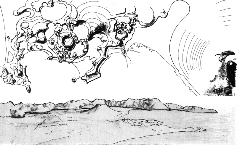
Fig.
2 - Salvatore Bisogni and Agostino Renna, Introduction to the Naples
urban design problems. Visual and kinaesthetic enjoyment fields of the
amphitheater system, 1963-64.
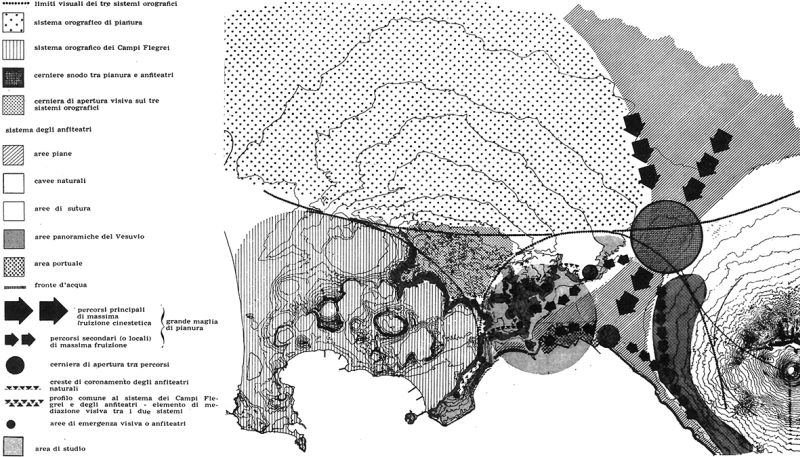
Fig.
3 - Salvatore Bisogni and Agostino Renna, Introduction to the Naples
urban design problems. Expressive model for emerging areas, lines and
fabrics, 1963-64.
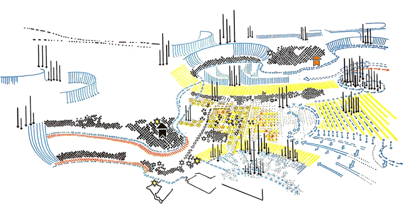
Fig.
4 - Carlo Doglio and Leonardo Urbani, Neapolitan area. Structure of
territory and liquefaction (liquidation?) of artifact, 1970.
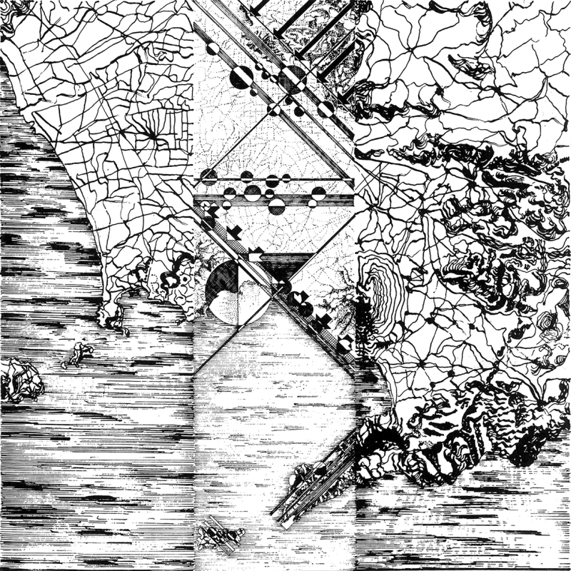
Fig.
5 - Carlo Doglio and Leonardo Urbani, La fionda sicula. Piano della
autonomia siciliana. Text and context: identification of formal
presences corresponding to Belice valley, central-southern belt,
Corleone and Palermo area, Etna, 1972.
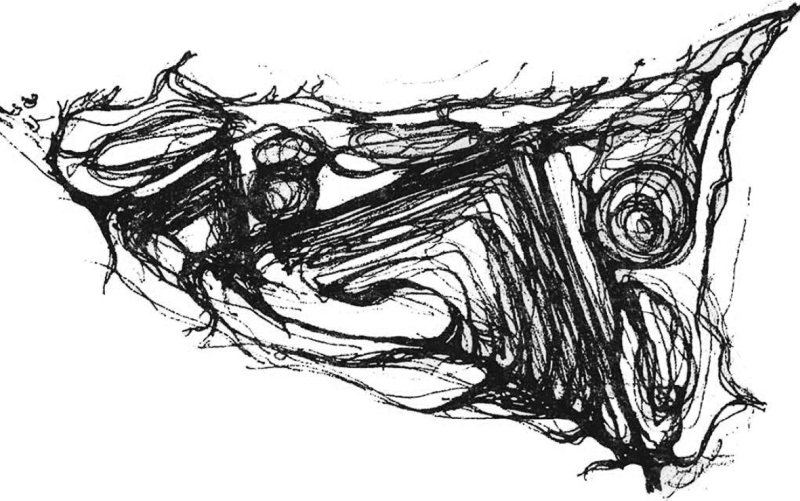
Fig.
6 - Carlo Doglio and Leonardo Urbani, La fionda sicula. Piano della
autonomia siciliana. Polyducts and land use, 1972.
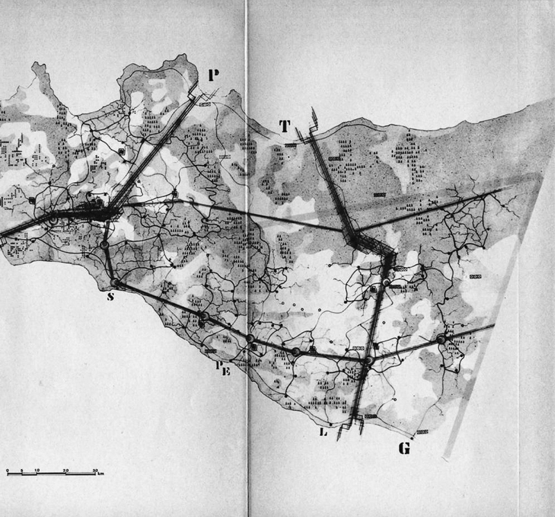
Fig.
7 - Michele Procida, Braccio di bosco e l'organigramma. Forest Arms,
1984.
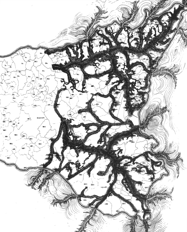
Fig.
8 - Leonardo Urbani, Braccio di bosco e l'organigramma. The birth of
design, 1984.
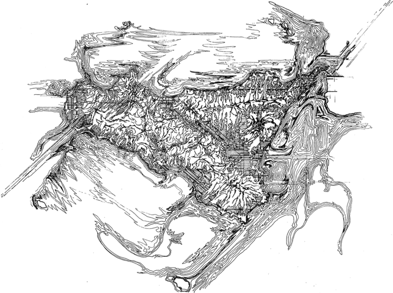
Fig.
9 - Nicola Giuliano Leone, Braccio di bosco e l'organigramma. The three
Sicilies: Ionian, Tyrrhenian and of the African canal one, 1984.
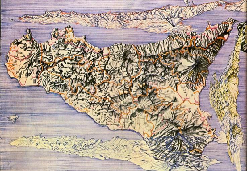
Fig.
10 - Nicola Giuliano Leone, A “perspective” for the
Amiata
Project: preparatory drawing (general plan of the territory of Mount
Amiata's mountain community, Indian ink and pastel on glossy paper) and
perspective (final version, with names of urban centers and
boraciferous soffions, Indian ink on glossy paper), 1979-1981; Logo for
the Mount Amiata producer cooperatives, Indian ink on glossy paper,
1981.

The topic of drawing here addressed is related to the transition in
scale of the architectural design: on the capability and consistency of
Drawing in representing and communicating a spatial form and an idea of
space even to the big scale, territorial and geographical.
The development of territory representation
proceeds hand in hand with the succession and evolution of the visions
of territory
that change over time, which is why we want to initially propose the
events that over the course of the second half of the twentieth century
led to the most recent theories, as well as the related forms of design
writing.
Since the last century, the relationship between space and
time has
changed radically, both in terms of technological advancement that has
increased the speed and expansion of settlement and infrastructural
processes, and in terms of the increasing speed of travels and the
possibility to reach every part of the globe in ever shorter time. As
man’s radii of action and the extension of his interventions
change, the dynamics of mutation in the territory vary accordingly and
with them the scales of the project, which must confront broader
dimensions and new topics that no longer concern only the scale of the
city and its surrounding but the bigger scale of the territory in which
the former is included.
However, the combination and expansion of these accelerating
phenomena has made evident the inadequacy of the usual design tools and
the absence of big scale intervention techniques capable to control the
effects or provoking them. This opens at both practical and theoretical
levels to reflections that concern not only the research for an updated
design methodology, but also the need for an appropriate means of
expression to represent its intents.
The design in the territory
The design at the territorial scale was until the last six
decades
linked to the theme of the city; only after a series of events it did
assume its own thematic autonomy. It was in fact the onset of problems
related to conurbation and uncontrolled city expansion that gradually
shifted the plane of architectural debate beyond urban limits.
In 1930 the geographer Walter Christaller published his theory
on
central locations, in which the city was considered in an integrated
view as the physical pole of the surrounding territorial system. From
that moment, as Emilio Battisti states, the city is recognized as
structurally connected to its territorial surroundings; a connection
from which it will no longer be «conceptually admissible to
speak
of the city in isolation from the territory» (1975, p. 224).
It was evident that something was changing: new and relevant
topics
required the widening of the viewpoint towards broader dimensions and
new criticalities heralded the need for renewed tools to push beyond
the design and functioning of the forma urbis.
The apparent unresolved disagreement between city and countryside[1]
on the one hand, the problems related to the dislocation relations
between production-service-residence places on the other, and finally
the changing physiognomy of the city into a metropolis, or megalopolis,
which, was advancing unchecked engulfing the surrounding land in
disorderly fashion, gave an account of an indisputable truth: in order
to defuse some of the effects produced by modern urban planning
practices, it was not enough to have recourse to predictive logic and
zoning, but it was necessary to question of new spatial figures capable
to find answers to the emerging problems[2].
Such was the premises of the 1962 Stresa Conference in which city-territory
was the central theme, a new dimensional entity that was now to be
based on the decentralization of the city’s load-bearing
functions and their more extensive and homogeneous re-location.
«What is the fundamental dimension to be referred to in our
urbanistic development hypotheses? What, too, is the structure that
frames our formal research?» (1962, p. 16). These are the
fundamental questions that Giorgio Piccinato, Vieri Quilici and
Manfredo Tafuri ask about the current situation: that is, does the term
of city-territory indicate only a change in scale
or also a different visual angle in dealing with the rapid changes that
were taking place?
The design of territory
Parallel to the hypotheses for countering peripheralization
and
urban sprawl that still identify the system-city as the sole focus to
be resolved, a different point of view is asserted extending the
concepts of space and architectural form to the entire territorial
context. The urbanocentric conception is abandoned in favor of a vision
that recognizes the structure and materiality of the entire territory,
as a concrete space operable through the tool of the project design: a
morphological context of which the city represents only one of the
elements contained therein, on par with the natural facts and the other
anthropic signs; as well as an autonomous system and an exhaustible
resource, to be understood, re-signified and protected through
architectural operations. Similarly, territory represents the result of
the layering of successive actions. And this means not only more or
less modified physical environment, but also behavioral attitudes to it
refered (Olivieri 1978, p. 14).
«Territory is not a data, but the result of several
processes», André Corboz writes about it.
«In other
words – he continues –, territory is object of
construction. It is a kind of artifact. And since that it also
constitutes a product. [...] Consequently,
territory is a project. [...] These different
translations of territory into figures refer to an indisputable
reality: that territory has a form. Indeed, that
it is a form. Which, of course, doesn’t
necessarily have to be geometric» (1985, pp. 23-24).
In light of the current conditions, the territorial topic is
now
more central than ever since new and different complexities related to
the advance of a conflict involving both marginal and extended
territories are added to the previous ones, in which forms, practices
and cultures acting through complex relationships and ancient balances
are dying out (Falzetti 2015, pp. 10-11). Reasoning about the
capabilities of architectural design as a tool able to producing
visions and about the process of form’s
construction,
which has no dimensions but rules and principles, thus becomes
necessary to analyze and understand the phenomena of the world and to
be able to intervene in his processes of transformation that affect all
scales of the artifact: from the building, to the city, to the
territory.
The drawing of territory
The term construction indicates to the
territorial and
geographical dimension a practice that is not exclusively about
building, but about the meaning and value of a process of
reinterpretation and formal restructuring of the existing. In the
architectural design on the grand scale, which contributes to the
construction of a formal whole, not only the dimensions but also the
composition of space change, determined by the spatial relationships
between distinct, even distant, elements. In relation to the space
to be represented, therefore, the type of representation
of space
changes, which must describe not only different scales but also the
elements and relationships that define it, as well as communicate, even
at this scale, a spatial form and idea of space. Canonical drawings
such as plans, sections and elevations, often referring to artifacts of
the smallest dimensions, are thus replaced by planimetric and
perspective views suitable for reproducing the field under examination
in its entirety. Similarly the urbanistic illustrations give way to the
invention of an almost biographical writing aimed to describe
intentions and interpretations through the use of an expressive code
«that stands halfway between concept and image»
(Pellegrini
1966, p. 103)[3].
A very important date for the historical and thematic
development of
the topic is that of 1963-64, the year of Salvatore Bisogni and
Agostino Renna’s graduation thesis precisely titled Introduction
to the Naples urban design problems[4].
It is no coincidence that this turning point occurs just in Naples, an
area in which natural facts, first and foremost that of Vesuvius, which
has always been a physical and symbolic landmark of the Parthenopean
environment, impose themselves with considerable formal and evocative
impact.
The study questions the big scale morphological problems in
the face
of the research for a design methodology that seeks to overcome the
operational impasse, which is why a non-descriptive but more
specifically design point of view is applied. Initially, the authors
perform a decomposition of the field by analyzing the present features
in isolation, to finally propose an urban model without hierarchy of
levels, in which orographic structure and building fabric, natural
pre-existences and anthropic layout, constitute a formal and
inseparable continuity: a complex «[...]
“Design” not
to be understood as a visually well-ordered whole, but as a “field”
of formal relationships between the constituent elements»
(Bisogni and Renna 1966, p. 131).
The term Design here takes indeed on the
double meaning of
tool and composition; it is both a means of representation and the
object of representation itself. This is important to grasp that the
theme of Bisogni and Renna’s work is twofold, as it
investigates
in its entirety the design question of big scale but also the problems
related to its representation. «The set of their drawings,
suspended in a productive ambiguity between symbolic image and
objective projection, is [...] capable to depict all the material,
geographical, typological and historical complexity of an urban and
territorial whole», Vittorio Gregotti in fact writes (1974,
p.
7). Bisogni and Renna state that they initially operated in the usual
way, using planimetric drawings to represent the organizations of the
area; then, through diagrams and bird’s-eye views (Figs. 1,
2),
«it appears the attempt to substitute for realistic
type direct annotations some symbols tending to represent relations
between forms rather than forms»
(1966, p. 129). The representation of territory until then limited to
an urbanistic vision is definitively overcome by a drawing capable to
illustrate in an autographic and interpretative way what has been
analyzed but also what has been inferred and proposed: the images of
concrete forms are transported to the plane of symbolism and formal
evocation, highlighting the formal relations among them through the
preparation of expressive models (Fig. 3),
synthetic and
evocative elaborations in which suggestions and one’s own
interpretations are also translated into drawing.
Several design researches began in those years, now focusing
on the
form and structure of the territory. Carlo Doglio and Leonardo Urbani
constitute two particularly relevant figures and, for academic reasons,
also in some ways two bridges between Naples and Palermo regarding the
applied methodology. At the base of their design theories are inferred
a certain degree of abstraction that unties the
form-structure dynamic of the territory to the system that identifies
it in a given period, and the use of an expressive language capable of
offering cultural interpretations of the territory (Doglio and Urbani
1970, p. 35). These assumptions are perfectly matched by the visions
the two architects propose for Naples (Fig. 4) but above all for
Sicily. Specifically, the drawings in support of La fionda
Sicula. Piano della autonomia siciliana[5] (Figs. 5, 6) and Braccio
di bosco e l’organigramma[6]
(Figs. 7, 8, 9) fully demonstrate the complexity to illustrate a
discourse that holds together the natural and the intangible data,
whether economic or administrative. And it’s precisely the
research for a mathematically impossible sum between
different elements
that leads to a form of drawing that must at certain times necessarily
abandon objectivity in order to succeed in communicating an idea. The
result is drawings that partly depict the structure of the territory
through the analysis of orography, and partly drawings (of considerable
aesthetic content both for creative invention and technical execution)
to whose formal interpretation is entrusted the sense of design
intention.
One of the main draughtsmen of Doglio and Urbani’s
works was
Nicola Giuliano Leone, architect and urban planner, author of several
projects and town and territorial plans in Italy and abroad. His
representations constitute the distinctive feature of his projects,
true «endo-products capable to communicate immediately the
idea
of city and territory in a virtuous symbiosis of sign and
thought» (Gabellini 2020, p. 10). This is patient and
meticulous
work for which digital means of representation can hardly replace the
communicative power of a hand stroke with great artistic and expressive
value. One experience in particular sums up the importance of drawing
as a research tool in Leone’s work. In 1979 he was
commissioned
to curate a perspective that would serve as an icon for the tourist
launch of Mount Amiata and to construct a trademark for the production
of pork sausages started on the same mountain (Fig. 10). Drawing, taken
as a figurative medium through which to understand, to rationalize and
to shape the existing, here also becomes a tool to strengthen the
social cohesion of a physically unitary territory but divided into
eleven municipal administrations and two provinces. Like Vesuvius for
the Parthenopean capital, Etna for eastern Sicily and beyond, the
figurative constructions of Hokusai’s Mount Fujiyama and
Cézanne’s Sainte-Victoire Mountain, Mount Amiata
is
elected as a territorial and landscape reference for the construction
of an idea of territory, in which the physical element artificially
acquires social significance becoming a cultural icon.
«To represent the territory is already to take
possession of
it – Corboz writes indeed –. Now, this
representation is
not a cast, but a construction. One makes a map first to know, then to
act» (Corboz 1985, p. 25).
Through drawing, territory is broken down into forms that
attempt to
be known through its graphic geometrization. Similarly, in order to
design it will be necessary to intervene by recomposing the matter of
which it is made up, that is forms assembled in space. However, simple
orthogonal projections fail to exhibit the physical, anthropological
and immaterial complexities present in the territory. Thus we move on
to a less objectifying form of writing, sometimes pictorial, but able
to interprete the spatial phenomena of territory, cultural and formal
ones, as well as communicating through one and the same sign an idea of
design. Architecture Drawing, even at the territorial scale, therefore
constitutes an inextricable part of all its phases. In addition to
being a tool for analysis and representation, it is also entrusted with
the expressive channel: cooperating with the formal aspects, it is in
fact able to emphasize theme and accents; and through the use of a
specific stylistic code it allows us to understand, along with the
work, built or merely imagined, the author as well.
Notes
[1]
In this regard, Giuseppe Samonà proposes in 1976 his theory
about The city in extension,
whose ever actual key to understanding lies on the possible
«very
lively dialectic between the balances of the new spatial relations that
will be created between the agricultural territory that has become a
city in extension and the big natural territory that is not permanently
inhabited».
In: Samonà G. (1976) – La
città in estensione.
Atti della conferenza tenuta presso la Facoltà di
Architettura
di Palermo il 25 maggio 1976, STASS Stampatori Tipolitografi Associati,
Palermo.
[2]
In this same period were the spatial and figurative researches of
Ludovico Quaroni, the experiments on the theme of the unicum
of business centres or territorial parks, or even those on the continuous
city
somehow already introduced at the turn of the 1930s by Le Corbusier who
coins the term of geo-architectures: city plans that are developed on
the grand scale proposing in the same sign a housing system and a model
of mobility.
[3]
Cesare Pellegrini’s design proposals published in 1966 in La
Forma del Territorio of «Edilizia
Moderna» No. 87-88, a sort of compositional exercises defined
by the same author with the terms of figurative qualifying
interventions,
demonstrate in this sense an employment of drawing not as a tool of
representation but as a means of composing. Pellegrini works with the
precise intention to reorganize the structure (to restructure
precisely) of a part of territory through the insertion of signs, often
abstract and of uncertain entity but charged with formal
intention, that introduce image potential into the
surrounding.
[4]
The work related to the
dissertation (Supervisors: Profs. Giulio De Luca and Francesco
Campagna) was initially published in 1966 in the monographic issue
edited by Vittorio Gregotti La Forma del Territorio
of «Edilizia Moderna» No. 87-88 and later, in 1974,
in the volume Il disegno della città di Napoli by
the same authors Salvatore Bisogni and Agostino Renna with an
introduction by Gregotti.
[5]
The project of La fionda sicula
is first and foremost about the vision of a Sicily as a central point
and bridge of exchange within the Mediterranean, proposing a new
framework of territorial infrastructures (the polyducts)
to make crossing and internal transportation easy; then also a Plan
for the autonomy
of a region that is careful of own resources, which focuses on its
territorial talents to undertake production activities and a new
economic development. In: Doglio C. and Urbani L. (1972) – La
fionda sicula. Piano della autonomia siciliana. Il Mulino,
Bologna.
[6]
In Braccio di bosco e l’organigramma,
the two architects present a possible model for the administrative and
productive development of the region, in which natural geometries and
ideal geometries overlap generating a new territorial design governed
by a dual-regulatory approach. In the Forest
Arms, natural vocations prevail: these depart
from the island’s historical-natural lines of force,
constructing a territorial fabric for which a strict
constraint regulation are provided, aimed to safeguard and
to preserve its original characters. For the remaining areas, in which
instead territorial indifference prevails,
regulations will be with agile constraint,
that is, from time to time directed to the emerging needs of individual
productive districts and their enhancement. In: Doglio C. and Urbani L.
(1984) – Braccio di bosco e
l’organigramma. Flaccovio Editore, Palermo.
References
BATTISTI E. (1975) – Struttura urbana e
trasformazioni territoriali. In: V. Gregotti (edited by), Architettura
e urbanistica. Forma-spazio habitat. Fabbri, Milan.
BISOGNI S. and RENNA A. (1966) –
“Introduzione ai
problemi di disegno urbano dell’area napoletana”.
Edilizia
Moderna. La forma del territorio, 87-88.
CORBOZ A. (1985) – “Il territorio come
palinsesto”. Casabella, 516 (September).
DOGLIO C. and URBANI L. (1970) – “Da
Napoli e Palermo”. Parametro, 2 (July-August).
DOGLIO C. and URBANI L. (1972) – La
fionda sicula. Piano della autonomia siciliana. Il Mulino,
Bologna.
DOGLIO C. and URBANI L. (1984) – Braccio
di bosco e l’organigramma. Flaccovio Editore,
Palermo.
FALZETTI A. (2015) – “I limiti della
ricerca nel progetto della continuità”. In: Id.
(edited by), La città in estensione.
Gangemi Editore, Rome.
GABELLINI P. (2020) – Un disegno a
più dimensioni. In: N. G. Leone, Il
progetto urbanistico. Planum Publisher, Rome-Milan.
GREGOTTI V. (1974) – Introduzione.
In: Bisogni S. and Renna A., Il disegno della
città Napoli, Cooperativa editrice di economia e
commercio, Naples.
GREGOTTI V. (1987) – Il territorio
dell’architettura. Feltrinelli, Milan.
MURATORI S. (1967) – Civiltà e
territorio. Centro Studi di Storia Urbanistica, Rome.
OLIVIERI M. (1978) – Come leggere il
territorio. La nuova Italia, Florence.
PELLEGRINI C. (1966) – “Note per
un’architettura
del paesaggio: mitologia e specializzazione”. Edilizia
Moderna.
La forma del territorio, 87-88.
PICCINATO G., QUILICI V. and TAFURI M. (1962) –
“La
città territorio. Verso una nuova dimensione”.
Casabella-Continuità, 270 (December).