Globalism and Identity in Contemporary Mediterranean
Architecture. Opposition or Coexistence?
Ludovico Micara
Figg.
1-2 - Tripoli. Libya: satellite view of the Medina. (DigitalGlobe
2005). Tripoli, Libya: historical urban layouts in the Medina (from
Micara 2013a).
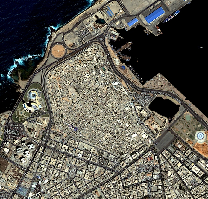
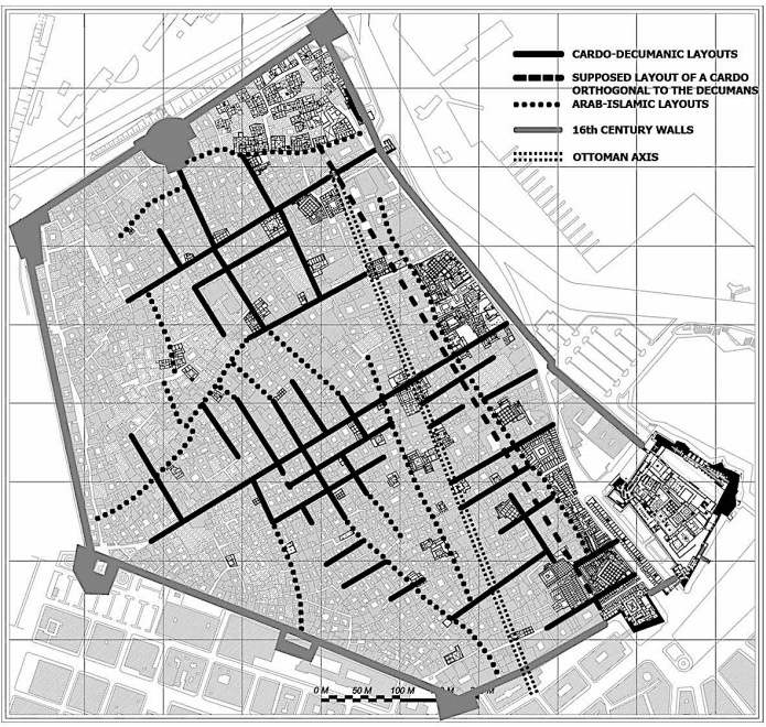
Fig.
3-5 - Tripoli, Libya: 19th-century view of the seafront of the Medina
from the port. Tripoli, Libya: view of the sea front and the port in
the 30s of last century. Tripoli. Libya: today’s view of the
sea front; beyond the great road the Medina with the Castle,
transformed by A. Brasini, and the past Bank of Libya, also by Brasini
(picture Micara 2010).

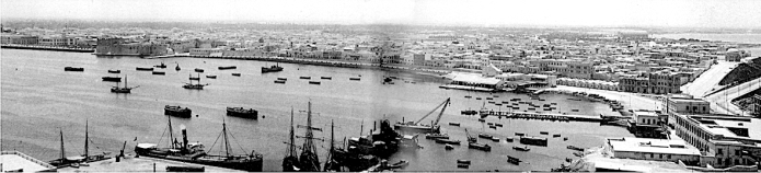
Fig.
6-7 - Tripoli, Libya: project of the new metropolitan dimension of
“Greater Tripoli”. (L. Micara: elaborated from
Clément 2005).
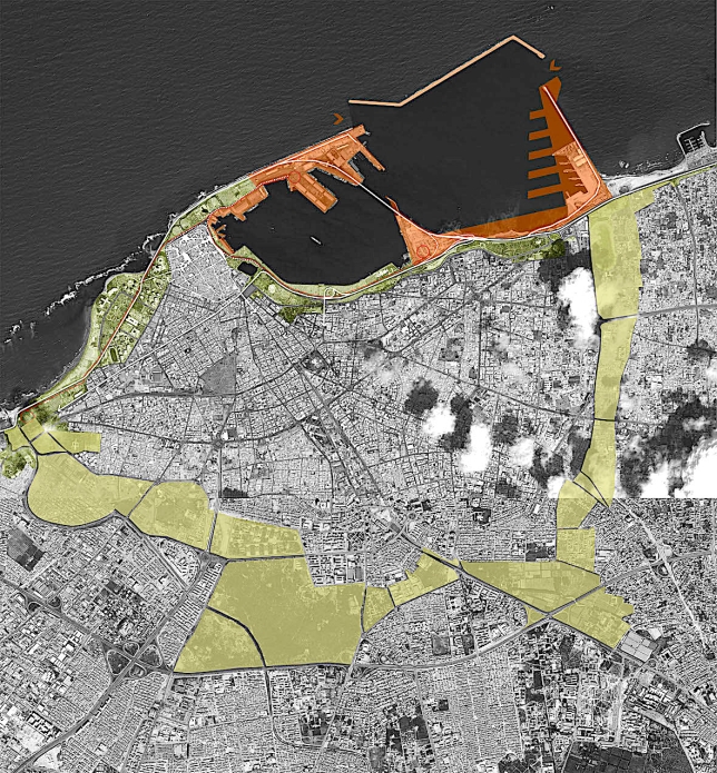
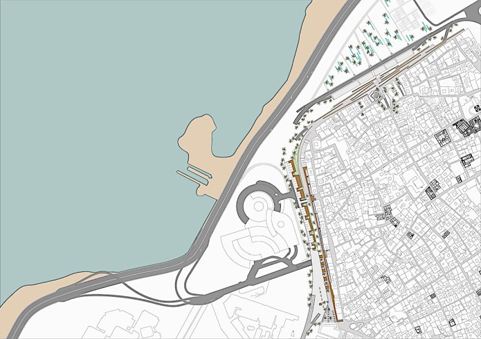
Fig.
8 - Tripoli, Libya: project for the new road that runs along the west walls of the Medina. (Micara 2015)
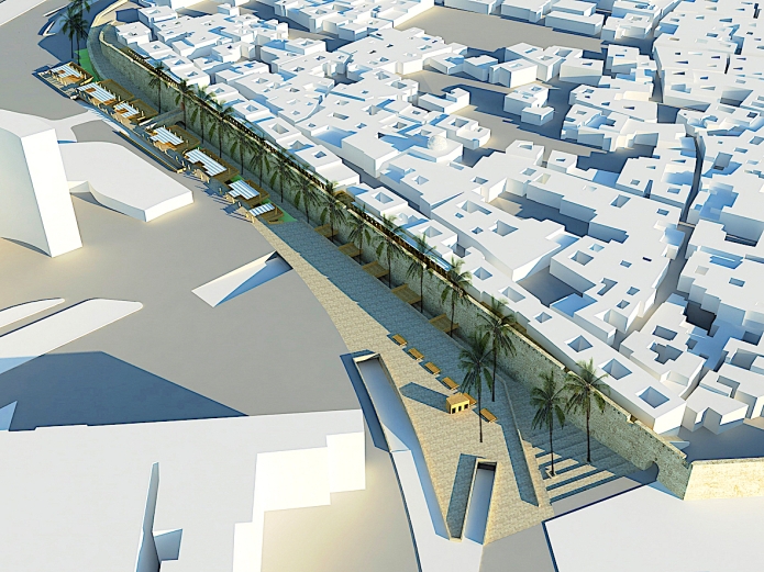
Fig.
9 - Tripoli, Libya: section of the urban park along the west walls of
the Medina; on the left, the walls, with the rampart walk at their top;
at the center, the promenade along the walls, and, on the right, the
underground road and the connection bridge to the surrounding levels
(Micara 2015).
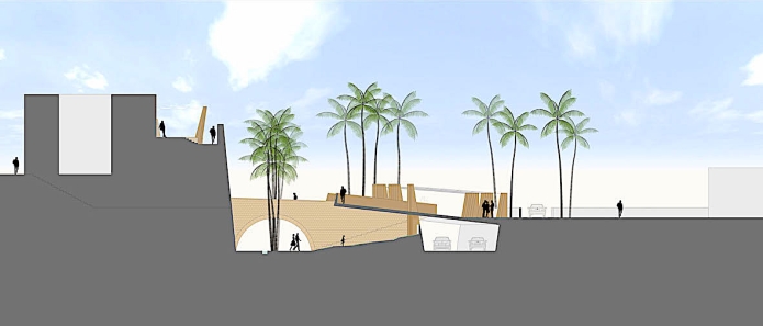
Fig.
10 - Tripoli, Libya: current view of the western walls. (picture by Micara 2015).
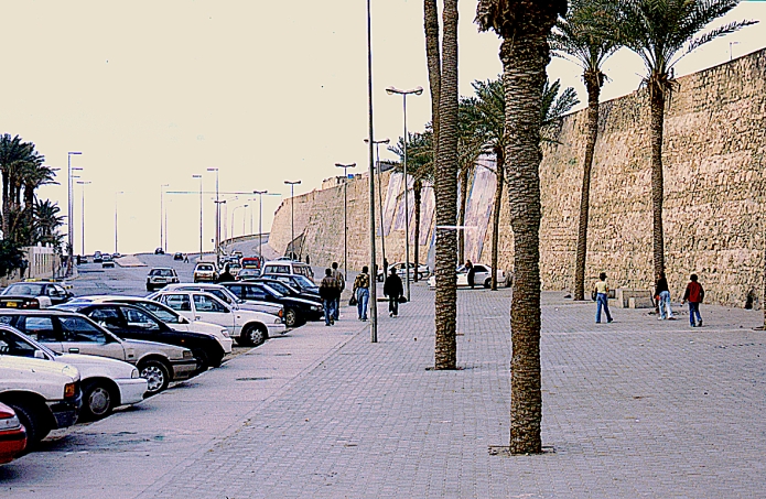
Fig.
11 - Tripoli, Libya: a view of the entrance to the walkway along the wall.(Micara 2015).
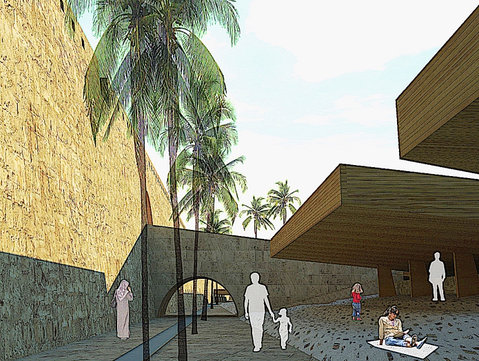
Fig.
12 - Tripoli, Libya: the walkway along the walls, with shaded rest areas (Micara 2015).
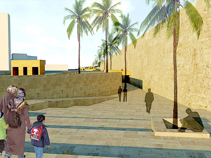
Fig.
13 - Tripoli, Libya: the rampart pathway on top of the walls. (picture by Micara 2015).
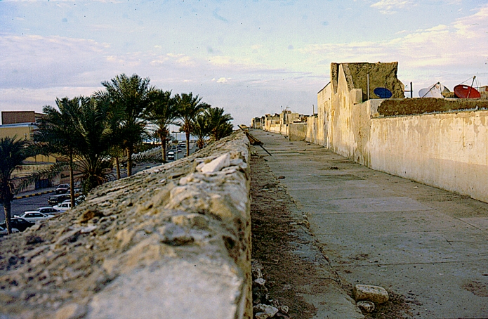
Fig.
14 - Tripoli, Libya: the panoramic open market on the rampart pathway on top of the walls (Micara 2015).
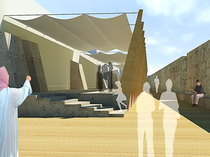
Fig.
15 - Yazd, Iran: Master Plan. In 1978, the Plan was awaiting to be
adopted, but this never happened. The green color indicates the
villages and their farmland around the city. In light green, the
proposed afforestation to prevent the advance of the desert. (Kowsar
2020).
Fig. 16 - Yazd, Iran: aerial view of the Yazd old center cut by the new roads (Kowsar 2020).
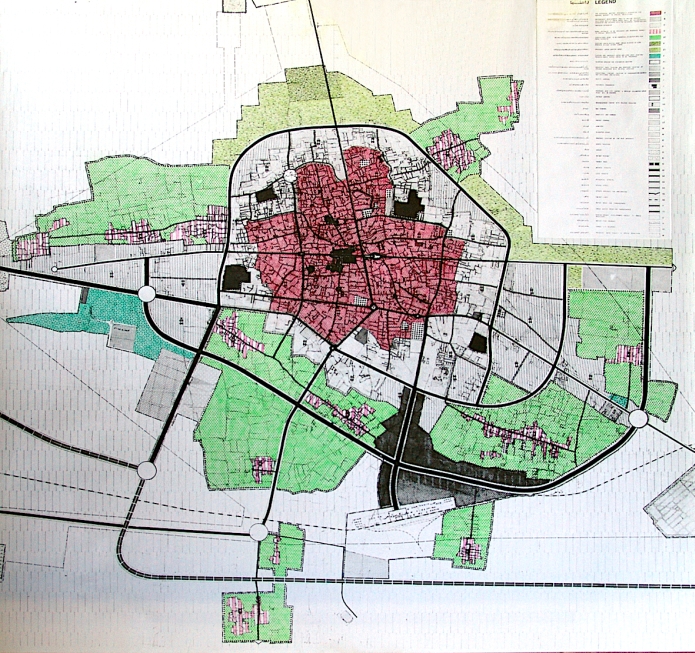
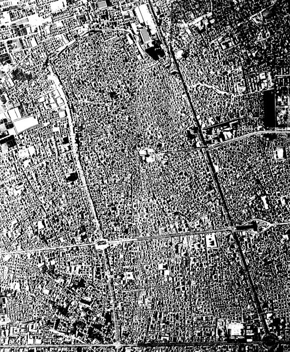
Fig.
17 - Yazd, Iran: project of rehabilitation of the ancient center. On
the left, the course of the existing walls, the urban structure of the
old city and the road plan, implemented after the 1972 demolition. On
the right, the design for the Seied Golesorkh street; the project, in
addition to proposing a solution for the destroyed urban parts with the
integration of new services, redesigns the façades of the street
(Kowsar 2020).
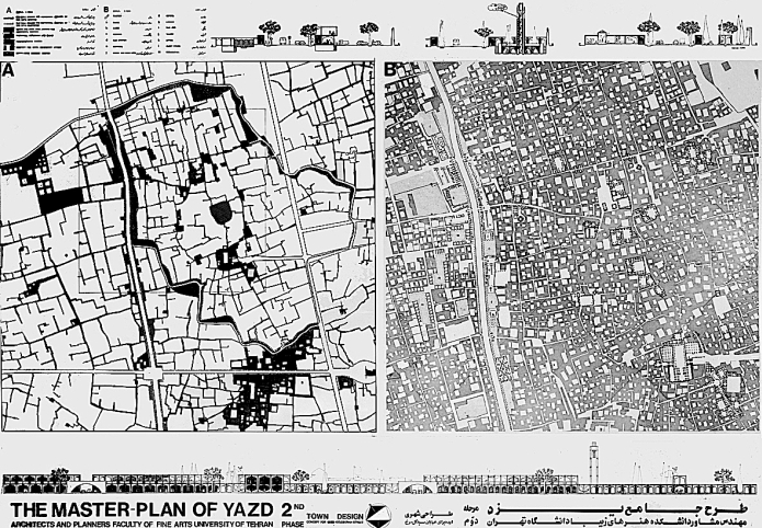
Fig.
18 - Yazd, Iran: details of the new arrangement of the Seyed Golesorkh
street, with the new services integrating the pre-existing ones with
the historical urban fabric (Kowsar 2020).

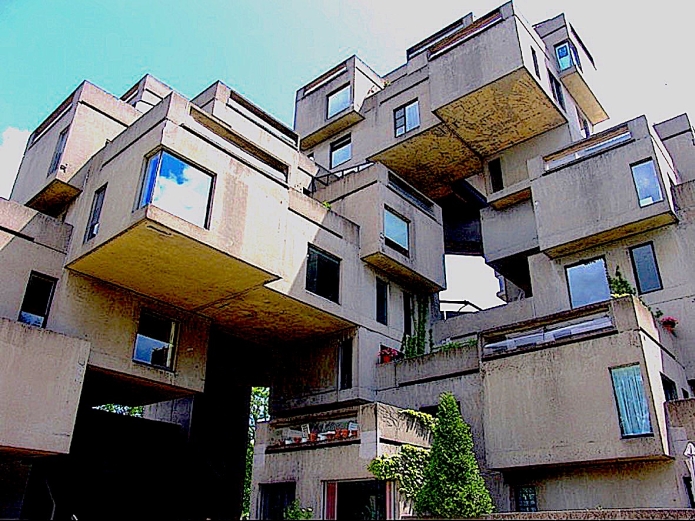
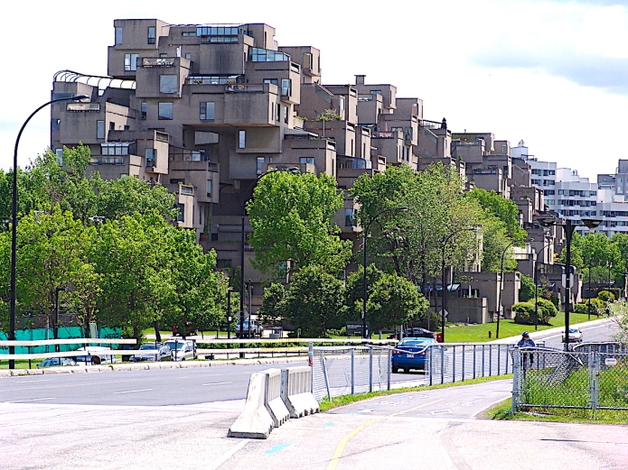
Figg.
19-20 - M. Safdie, Montreal Habitat ‘67 (pictures by Micara 1970).
The recent transformations of many cities show a continuous
and
progressive compromise between global pressures related to
modernization processes (new infrastructures, new public or private
services …) and resistance that comes from the very
existence of
identities, traditions, customs, uses still present and alive.
Let us take the case of the Mediterranean world, in which this
phenomenon is particularly evident. One of the cultural, religious,
anthropological components of this world, the Islamic one, which
developed mainly in the southern coast of the Mediterranean and in the
Levant, was once viewed as a global imprint on those regions.
When, around the 1960s, we were still talking of
“Islamic
architecture and cities”, Paolo Portoghesi in 1982 decided to
name the Second International Architecture Exhibition of the Venice
Biennale Architecture in Islamic countries
(Portoghesi 1982).
That represented a profound change because it was then acknowledged
that the simple adjective “Islamic” did not cover
the
complexity of the aspects the world of “Islamic
countries”
presented in the area of architecture and the city. Likewise, it is
difficult today to attribute a unity to the term “Islamic
world” if we think of the geographical differences, the
historical and social development of the various regions, also in
relation to the consequences of colonization and post-colonization, not
to mention the different modalities with which globalization has taken
place. As a consequence, the cities of Islamic formation incorporate
parts of fabric, fragments, environments, still referable to the
traditional “Islamic city”, as it was theorized at
the
beginning of the last century, but now amalgamated and merged with the
globalized city.
It would be interesting, today, to reconnect, at least
virtually,
the paths and the webs of Islamic fabrics beyond the fractures and
contemporary transformations, to rediscover how much we still owe to
this tradition in designing the identity and character of those cities.
Can we still rely on the historical-sociological analyses by
Ibn
Khaldun (Monteil 1967 [1378]) which oriented the subsequent studies by
W. Marçais (Marçais 1928), G. Marçais
(Marçais 1957), U. Monneret de Villard (Monneret de Villard
1966) G. E. von Grunebaum (von Grunebaum 1955), S. Bianca (Bianca 1964)
in order to recognize a specific formal structure to the urban spaces
of the so-called “Islamic world”? Or should we
consider,
instead, more recent field studies (Berardi 1979) to understand the
complexity of today’s cities in Islamic countries?
To this end, we will now analyze the case of the
Tripoli’s
Medina in Libya (Micara 2013a), and the plan for the city of Yazd in
Iran (Kowsar 2020).
Tripoli (Libya)
At the beginning of the 20th century,
the Medina of
Tripoli (Micara 2008a) (Fig. 1) admirably represented most of the
characteristics of the Mediterranean cities in Maghreb, namely, a
successful synthesis between typical aspects of the Arab-Islamic cities
and characters partly extraneous to that tradition deriving from the
intense activity of commercial, demographic, religious and diplomatic
exchanges with the countries bordering the Mediterranean Sea.
For instance, next to the mosques, the high and pointed
minarets
that clearly manifest the cultural and religious identity of the city,
and next to the dense and compact fabric of courtyard houses and narrow
alleys, often cul-de-sac, one can perceive
elements which are extraneous to the local urban tradition, such as the
walls and the castle, with the 16th-century
bastions, due to Charles the 5th Spanish
globalization, and an unusual opening of the houses to the street.
The uncommon regularity of some roads is also evident (Fig.
2),
which, after a more in-depth analysis, appears as a track of the cardo-decumanus
order, based on the supposed cardo[1] and the
two decumanus
of the Roman progenitor of the city, i.e., Tripolis-Oea (The name
‘Tripolis’ means ‘three
cities’, namely, Oea,
Sabratha and Leptis Magna). Some urban characters, such as the breadth
and airiness of the court-houses in Tripoli, mainly near the sea and
the port and reminiscent of the size of the Roman domus,
are
also noteworthy. Likewise, the presence of the church and the bell
tower of St. Mary of the Angels together with the many synagogues,
later transformed into mosques, clearly illustrate the multi-ethnic and
multi-religious dimension of the Medina in the past.
In addition, the prevailing orientation of the fabric toward
the
port unequivocally determined the Mediterranean character of the all
the spaces of the city (Micara 2009). Today’s Medina is
therefore
the result of a series of rewritings of the traditional settlement,
from the Roman to the Arab-Islamic, to the Ottoman one, up to the
Italian colonial city, and finally to the contemporary city. These
rewritings have transformed an ancient settlement, born as a trading
port in a large bay, in the pulsating heart of a metropolis of over one
and a half million inhabitants.
This new dimension has completely changed the relationships
between
the different parts of the city. During Italian occupation, the
demolition of parts of the city walls left traces in new streets, which
favoured the integration of the Medina with the Italian city of the
1930’s, giving rise to an unprecedented “historic
center”. Thus, the originality of this center results from
the
integration between a traditional Arab-Islamic urban pattern, based on
the court houses fabric, and the early 20th
century pattern,
based on the typological and morphological relationship between streets
and city blocks. Today, this historic core, much wider than the
traditional Medina, is still easily recognizable with its
architectures, ancient monuments, 20th century
arcades, and
the buildings of the “new” institutions of the
colonial
city. However, this integration is far from harmonious. While the
attention of the colonizers was all focused on the so-called
“Italian city” where the buildings of colonial
power were
located, and new urban axes were created, the labyrinthine urban fabric
of the Medina was left on the background. A still little known and
partly mysterious background, abandoned to its uncontrolled
transformations and social and religious ways of life, whose presence
constitutes however a fundamental component of the 20th
century idea of the Mediterranean Levantine city.
As a consequence of this approach, the most significant
transformations occurred in the areas of tangency and contact between
the two urban systems and therefore in the edges of the Medina. The
demolition of the walls made the resulting void area available for the
construction of new streets and new public buildings, while parts of
Medina’s fabric, close to the edges, became the object of the
“normalizing” attention by the colonial
administration.
Even today, the problem of the edges of the Medina is still unsolved,
and further aggravated by the presence of new buildings, such as large
hotels in the north-western area of the city or new infrastructures,
such as the beltway between the Medina and the port, which, by cutting
the historical connections between the urban fabric and the sea, even
more isolate the Medina itself.
Today’s biggest problem in Tripoli is its new
metropolitan
dimension. If we now look at a satellite image of the city, we can see
that its urban growth has taken place without any urban settlement
rules, and that the relationship between residential fabrics and public
spaces, so clear in the traditional Medina, has been lost.
The only ordering element of the “great
Tripoli” is
represented by the street infrastructures which partly retrace the
ancient tracks connecting the Medina to the inland areas and other
coastal centers, and partly define the new urban dimension through even
wider ring-roads. In particular, the creation of a great highway,
running along the waterfront between the Medina and the port (Fig.
3-4-5), is noteworthy.
This infrastructure, created to connect the port to the
principal
arteries of the city, has assumed the role of a great beltway which
avoids the city and therefore runs along the seaside. This beltway
heavily impacts on the structure of the Medina. What was, since the
origins, an urban fabric oriented towards the port, does not find today
an access towards the sea, and is now bounded and enclosed within a
barrier, constituted by a highway which cannot easily be crossed
(Micara 2013b, 2008b).
One of the original features of the urban fabric of the Medina
is
thus cancelled, which reduces its potential for rehabilitation. In
prospect, the displacement of the commercial port towards east, where
wider lands and infrastructure facilities are available, might entail
the displacement of the beltway or the reconsideration of its
relevance, which would leave room for a touristic port, and a possible
residential rehabilitation of the Medina. The Medina could thus
discover, by enhancing its links with the sea, one of its distinctive
characters since its foundation.
In the new metropolitan dimension of “Greater
Tripoli”
it is however impossible to intervene with partial programs, and a new
global strategic vision is needed, likely to interpret the new
geographical scale of the city. The urban project of the French
landscape architect Gilles Clément (Clément 2005)
demolishes a series of degraded and residual fabrics, délaissés,
in Clément’s terminology, integrating the voids
resulting
from demolishment with abandoned or not exploited areas, to create a
large metropolitan belt consisting of gardens, public spaces and
services (Fig. 6).
Developing Clément’s suggestions, the
extremities of
such belt could reach the sea, welding also the current harbor with
services of urban level in a single linear system. This process would
thus reconstitute, at metropolitan scale, the relationship between
residential areas and public spaces which is so important for the
quality of the urban fabric of the Mediterranean Medina.
If, at urban scale, the issue of great circulation raises the
problem of the general transformation of the harbor system, in more
limited areas it is possible to make the new infrastructures interact
with the historical context of the Medina.
This is the case of the west border of the Medina, where the
ring
road runs along the still existing walls (fig. 7). As an alternative to
a solution of pure tangency between two entities extraneous to each
other, it is thus possible to think and plan their mutual involvement
to achieve that integration so characteristic of many Mediterranean
urban fabrics (fig. 8).
The discovery of a picture of the Italian colonial period
testifies
to the presence of a moat along the ancient walls and an entrance gate
to the Medina where the former Jewish ghetto was located, named hara
in Arabic. It is then possible to recover this level, lower than the
surrounding ones, to design a walkway and an urban park along the walls
(fig. 9-10-11-12).
Making the highway subterranean will allow direct access to
the
Medina from the surrounding levels, while the rampart pathway on the
top of the walls could become a panoramic open-air market (Fig. 13-14).
Yazd (Iran)
At Yazd (Kowsar 2020), an ancient Persian city at the edges of
the
central Iranian desert (fig. 15), a similar problem, related to the
modernization of the historical centers related to new road
infrastructures, is also present.
In this case as well, the construction of new roads within the
historical fabrics has been a type of urban intervention extensively
adopted by the Iranian cities in the last century (Fig. 16). The
interaction between the new infrastructures and the original features
of an important ancient center would suggest an urban project
implementing a new and more complex synthesis between preservation of
identity and globalization.
We can distinguish two moments in which these interventions
have
been carried out in the past. The first one took place during Reza Shah
Pahlavi’s modernization period (1925-1944), to solve the
issue of
the access to dense and compact historical urban fabrics of Iranian
cities. The second one, more recent, can be traced back to the 50s and
60s of last century, before the principles of conservation and
restoration of the architectural heritage, not only related to the
so-called “monuments”, but also to the historical
urban
fabric, became established in the practice of urban design.
While the “wounds” and “real
cuts” produced
in urban fabrics by the first demolitions were repaired with
architectural systems characterized by continuous porticoed elevations
with shops inside, the most recent demolitions are recognizable by
other characteristics. For example, we can find random reconstruction
of new street façades, or partially demolished buildings and
houses, whose ruins, with interior spaces and courtyards, once kept
jealously hidden, are now exposed to the prying eyes of passers-by.
The consequences of such “cutting”
operations in the
historical urban fabric of Iranian cities have had a double
implication. The first is the interruption of the continuity of the
network of pathways and alleys (kuché),
historically connecting the houses or neighborhoods (mahallah)
to the main axis (rasteh) of bazaars,
caravanserais (caravanserai), public baths (hammam),
religious schools (madrasa)
and mosques. The strong unity and integration of the traditional fabric
is thus broken, in the absence of an alternative settlement model.
The second effect is the loss of relevance of the bazaar, as
the
commercial traditional center of the city, in favor of new shopping
streets, easily accessible by car. As a result, the bazaar has lost its
main quality in the past, that was to be the most important public
space of the city.
The objective of a possible redevelopment project (Micara
2020)
(Fig. 17-18) is therefore not just to define and design the road fronts
of new streets, such as Seied Golesorkh Street, but also to take
advantage of the demolished areas to organize some services
complementing those already present in the historical urban fabric.
The new urban façades have been designed (Micara
2020) by
proposing one or two-level porticos, built with prefabricated elements,
combined according to various configurations, and interrupted by large
arched gates which introduce to the main paths of the traditional urban
fabric. The new fronts of the street are not designed as a continuous
and compact wall, separating the road from the historical center, but
rather as a permeable and “porous” screen,
integrating the
new urban spaces with the pre-existing ones.
Global Identities: a contradiction?
The subject of a compact and continuous city, respectful of
the
nature of the cities of the Islamic world, and not resulting from the
mere addition of autonomous and isolated buildings, fascinated many
contemporary architects.
In La torre di Babele, Ludovico Quaroni
wrote:
With modern means it is possible that our new unit is not a
set of
buildings, and not just a building (skyscraper or container). Of the
single building it will have the feature of continuity: indeed, it can
have it much more, precisely because it will be free from the limits of
the body of building, of façades, of the site. Continuity,
in a
similar architectural subject, is the first and most important
characteristic. The continuous building will be able to be crossed, and
must be crossed in all directions, and not only horizontally, as we are
used to think; it may have a thickness, only that which corresponds to
the height of a floor, or that varies according to the different
points; it may also generate clusters of skyscrapers; it can be flanked
by a road, but it will more probably be distant from a road (highway),
or instead it will have it above or below or will be crossed by the
road from inside.
For air and light, holes and channels will be made in the
continuous
building to breathe the free air, all the times that natural light and
ventilation will have to correct artificial ones, limited to what it
will be needed (little) to maintain contact between man and the
alternation of day and night, between man and the clear sky, between
man and vegetation, openings. (Quaroni 1967)
How is it possible not to recognize the fascination of the continuum,
of the “continuous fabric” of the Islamic
Mediterranean in
the images Klee painted after his trip to Tunisia at the beginning of
the 9th century, or in the projects of G.
Candilis (Berlin
Free University Project, 1963), Y. Friedman (Project
for “The Spatial City”, 1961), the
Smithson (Project
of a pedestrian continuous level upon the Berlin central area, 1958) or
M. Safdie (Fig. 19-20)?
Therefore, one of the major identity elements of the cities of
Islamic formation, namely continuity, can be inspiring for new and more
complex urban sets. Isn’t the very term
“porosity”[2]
(“porous” architectures,
“porous” cities...),
which identifies architectural systems where full and empty spaces are
linked together by reciprocity and relationships, a good reference to
the characters of the just analyzed Medinas?
Looking at the last images, and back to the title of this
paragraph,
“Global identities”, we may say that the identity
feature
of the Mediterranean architectures and cities aspires to be global,
thus reverting the initial opposition from which this study started.
Notes
[1]
The currently
accepted identification of the cardo of the Roman Tripoli-Oea, with the
long straight road, called Sciara Arba’a Arsat and Sciara
Jama
el-Druj, raises some doubts. The latter, in fact, is oblique in
relation to the axes of the arches of the Tetrapylon of Marcus
Aurelius, then center and umbilicum of the city, unlike the decumanus
that is perfectly oriented with the axis of the main fornix of the
Tetrapylon itself. Moreover, the routes transverse to the supposed
cardo are not orthogonal to it, as is usually the case for a Roman
cardo-decumanus layout, but oriented like the decumanus. In absence and
waiting for archaeological evidence, it can be assumed that the
so-called cardo is an Ottoman transformation, due to the destructions
made by the Spanish and the Knights of St. John in the urban area west
of the Castle, in order to defend and reinforce it against the Ottoman
attacks.
[2]
Sometimes it is worth going
back to the sources and to read again an exemplary text, not written by
architects, that, back in 1924, suggested the
“porosity”
term (Benjamin and Lacis 2020).
References
BENJAMIN W. e LACIS A. (2020 [1924]) – Napoli
porosa. Edizioni Libreria Dante & Descartes, Naples.
BERARDI R. (1979) – “Espace et ville en
pays d’Islam”. In: D. Chevalier (a cura di), L’espace
social de la ville arabe. Maisonneuve et Larose, Paris
99-123.
BIANCA S. (1964) – “The Islamic City:
Physical
Layout”. Urbanism and Urbanization. International Studies in
Sociology and Social Anthropology, II, Leiden.
BUCARELLI P. (1970) (edited by) – Paul
Klee (1879 – 1940). (Exhibition in collaboration
with Goethe-Institute of Rome and the Fondazione Pro Helvetia, Roma
1970). De Luca Editore, Rome.
Clément G. (2005) – Manifesto
del terzo paesaggio. Editions Sujet Objet, Macerata.
GEELHAR C. (1972) – Paul Klee et
le Bauhaus, Editions Ides et Calendes, Neuchâtel.
JENCKS C. (1973) – Modern
Movements in Architecture. Penguin Books, Oxford.
KOWSAR M. (2020) (a cura di) – “Alla
ricerca del
Continuum: Quaroni a Yazd”. L’ADC
L’architettura
delle città. The Journal of the Scientific Society Ludovico
Quaroni, 17.
MARÇAIS G. (1957) –
“L’urbanisme
musulman”. Mélanges d’Histoire et
d’Archéologie de l’Occident Musulman, I,
219-231.
MARÇAIS W. (1928) –
“L’Islamisme et la
vie urbaine”. Comptes rendus de
l’Académie des
Inscriptions et Belles Lettres, Paris, 86-100.
MICARA L. (2008a) – “The Ottoman Tripoli:
A
Mediterranean Medina”. In: S. K. Jayyusi, R. Holod, A.
Petruccioli, A. Raymond (edited by), The City in the Islamic
World. Leiden, Brill, 383-406.
MICARE L. (2008b) – “Tripoli:
l’affaccio a mare di una medina mediterranea”.
Portus, 16, 78-85.
MICARA L. (2009) – “The Model of the
Medina of Tripoli:
a Unique Contribution to the Understanding of the Mediterranean
Cities”. In: L. Micara A. Petruccioli, E. Vadini (edited by),
The Mediterranean Medina. Gangemi Editore, Rome,
440-446.
MICARE L. (2013a) – Tripoli medina
mediterranea. Gangemi Editore, Rome.
MICARA L. (2013b) – “Rewriting the
Mediterranean Cities:
Geography of Transformation”. In: A. Petrov (edited by), The
Mediterranean. New Geographies, Harvard University School of
Design, 05, 285-302.
MICARA L. (2020), – “The Rehabilitation
Proposal for
Seied Golesorkh Street”. L’ADC
L’architettura delle
città. The Journal of the Scientific Society Ludovico
Quaroni,
17, 155-158.
MONNERET De VILLAR U. (1966) – Introduzione
allo studio dell’archeologia islamica. Istituto
per la Collaborazione Culturale, Venezia-Roma.
MONTEIL V. (1967 [1378]) – Ibn Khaldun,
Discours sur l’histoire universelle (al-Muqaddima).
Commission internationale pour la traduction des
chefs-d’oeuvre, Beyrouth.
PORTOGHESI P. (a cura di) (1982) – Architettura
nei paesi islamici. Seconda mostra internazionale
di architettura. Electa Editrice, La Biennale di Venezia,
Venice.
QUARONI L. (1967) – La torre di Babele.
Marsilio Editori, Padova.