New towns and new countryside in Italy from corporatism to
post-war reconstruction
Francesca Bonfante, Luca Monica
Fig.
1 - Map of the land reclamations in Italy, according to the
Serpieri’s law, between 1931 and 1935 (from Serpieri
1931-1935).
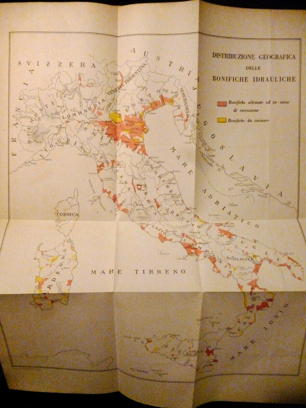
Fig.
2 - Excavators at Casale Perazzotti, Acque Alte channel, near Latina,
in 1929 (from Zucaro 2012).
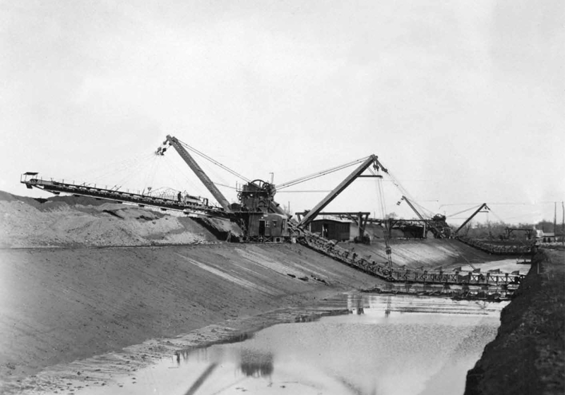
Fig.
3 - G. Cancellotti, E. Montuori, L. Piccinato, A. Scalpelli, Town of
Sabaudia, 1933-34. Functional diagram of the city (from Piccinato 1934).
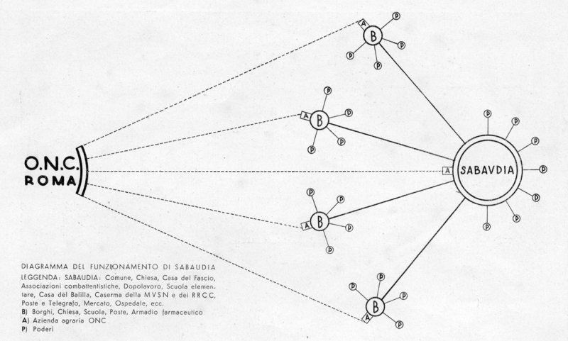
Fig.
4 - G. Cancellotti, E. Montuori, L. Piccinato, A. Scalpelli, Town of
Sabaudia, 1933-34. Project plan of the city (from Piccinato 1934).
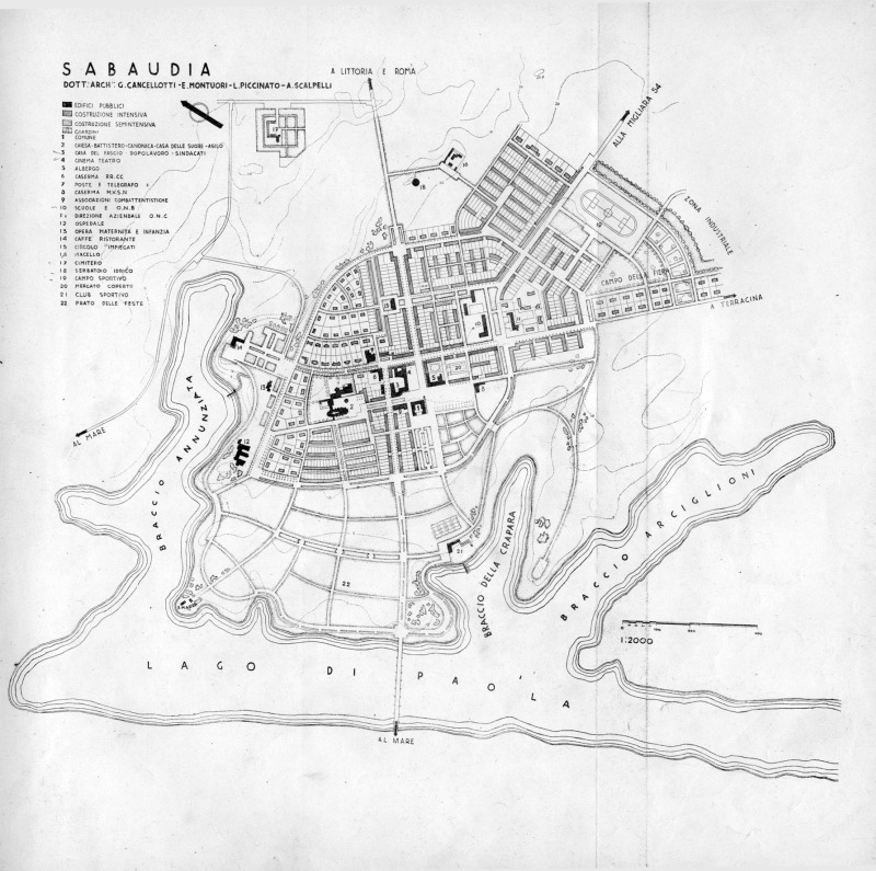
Fig.
5 - G. Cancellotti, E. Montuori, L. Piccinato, A. Scalpelli, Town of
Sabaudia, 1933-34. Perspective drawings of the centre (from Piccinato
1934).
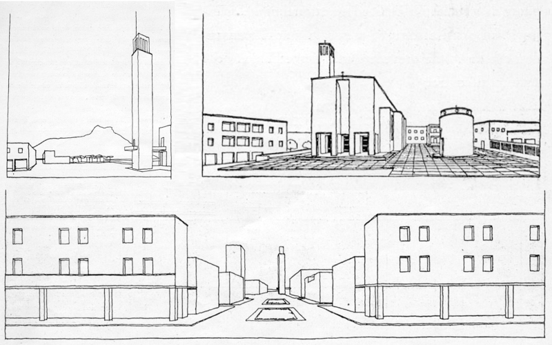
Fig.
6 - Aerial views of Sabaudia (from Sabaudia dall’aeroplano
1935).
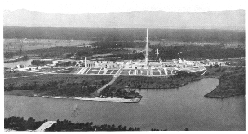
Fig.
7 - Aerial views of Sabaudia (from Sabaudia dall’aeroplano
1935).
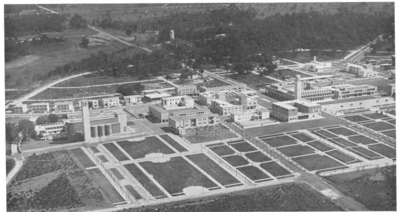
Fig.
8 - Le Corbusier, Study drawing of the Pontinia proposal, 1934 (from
Ciucci 2012).
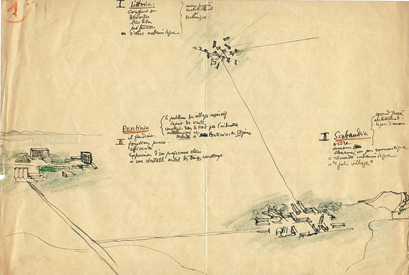
Fig.
9 - Mario Ridolfi, Project for modular rural houses for CNR and
UNRRA-Casas, 1949. Archivio Accademia Nazionale di San Luca, Roma.
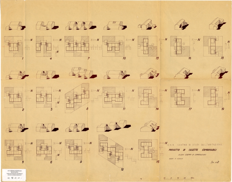
Fig.
10 - L. Quaroni, L. Agati, F. Gorio, P. M. Lugli, M. Valori, La
Martella village, Matera, 1949-54. Project plan (from Olivetti 1952).
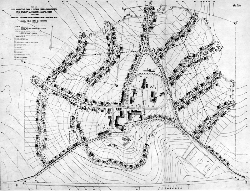
Fig.
11 - Aerial view of La Martella (from Tafuri 1964).
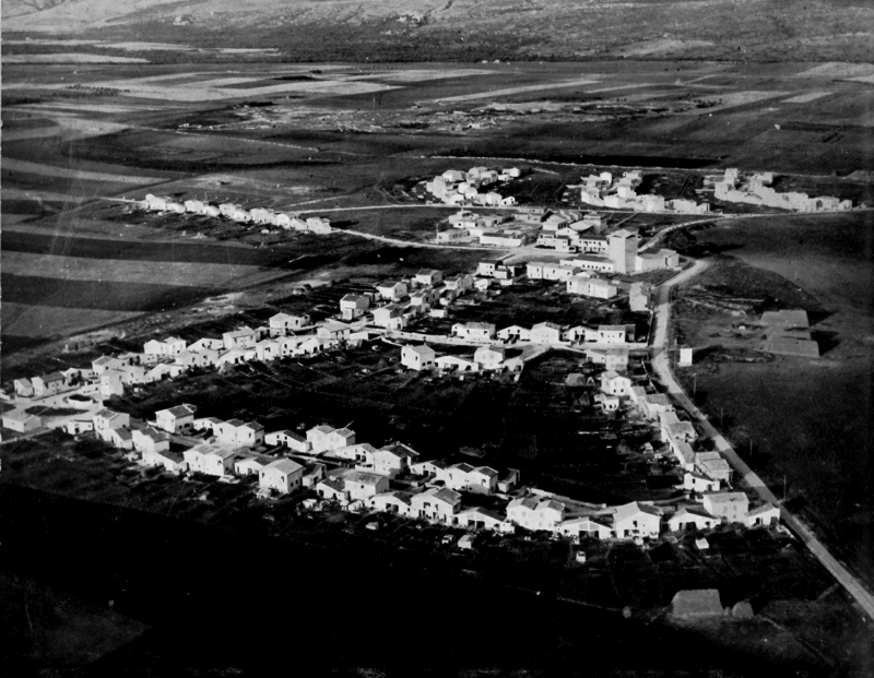
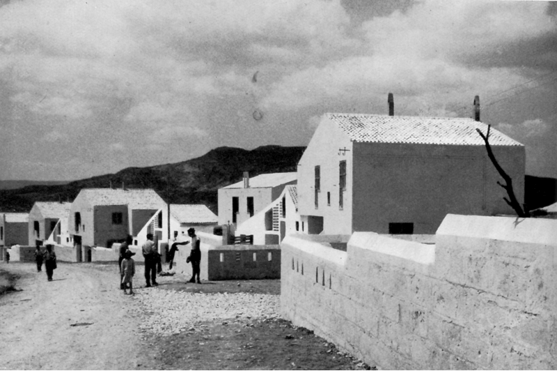
Fig.
12 - Houses of La Martella (from Gorio 1954).
Introduction
The literature on the transformation of the Pontine Marshes
and the construction of the new towns is very
broad and belongs to the different fields of knowledge directly
involved in the project of integral reclamation,
from economy to politics, from agronomy to history of the landscape,
from geology to hydrography, from urban planning to architecture. It is
therefore difficult to untangle the complex interweaving of knowledge
available and the many contemporary criticisms made at the time and
after the project.
Many studies on Italian architecture and urban planning of
interwar time (mostly published in the 1970s and 1980s) deal with the
intricate political and cultural events of fascist Italy, often
criticising projects undertaken in the Pontine Marshes. These authors
put into question the actual ability of the Fascist regime to
organically plan economy, society and territory, while stigmatising
Italian architects who embraced rationalism for compromising form
and ideology, rather than finding real
alternatives to regime architecture (Mariani 1976, Sica 1978, Nuti and
Martinelli 1978, Ciucci 1989).
However, beyond propaganda, the reclamation of the Pontine
Marshes is a key case study to question the relationship between the
actual building sites and the ideas behind them, between methods,
results and contradictions of the fascist territorial management.
There are still some open questions about the role played by
the rural alternative in the strategy of a possible rebalancing between
city and countryside.
As well as the historical judgement on the effects on the
economic development of actions linked to the principles of the integral
reclamation has been complex and many-sided. On the one
hand the reclamation produced an increase in agricultural production
but on the other it was unable to carry through its promise, i.e. a
genuine «renewal of production structures and the formation
of small-scale active and enterprising holdings backed by public land
credit system» (Castronovo 1975, p.281).
These effects, it was recognized, did however form the
instrumental promise for a revival which occurred starting from the
1950s, especially in the south of Italy, as mentioned by Manlio Rossi
Doria:
Immediately after the war, the situation of southern
reclamation was extremely confused and uncertain. […] Those
years saw the formulation of principles that later found their
realization with the institution of the Cassa per il
Mezzogiorno [Fund for the South] and its programme: the need
for adequate consolidated multiannual appropriations, a long-term plan,
an extraordinary institutional body to realize it, a discrimination
between districts, a concentration of efforts on the most ready and
promising among them, a systematic study and investigation of the
countless reclamation issues, and ultimately, a close connection from
the outset between public works and land transformation, to finally
render Arrigo Serpieri’s luminous conception concrete in its
entirety also in the south. (Rossi Doria 1961, p.82-83. Transl. by
authors).
At the same time though, the economic background changed
radically. However, despite the new historical and ideological context,
architectural projects implemented after WWII were as exemplary as
those produced in the interwar period.
In fact, if the project for the Agro Pontino was the most
clear experiment among the integral reclamation
in the 1920s and 1930s, the same can be said for the district La
Martella, one of the most significant interventions of the ricostruzione
period, once again inconceivable outside the actions of the reclamation
consortia desired by the Serpieri laws, detailed here in a subsequent
paragraph.
The Italian question:
corporatism and ruralisation
The ruralisation of the country – through the policy
of integral reclamation – starting on massive public works,
found institutional support in Corporations that were supposed to
resolve a fundamental contradiction of capitalism, i.e. the conflicting
relationship between employer and workforce. Giuseppe Bottai, Minister
of Corporations, tried in as dynamic a way as possible to interpret
this institutional tool which was meant to cut right back to the roots
and causes of latent conflict[1].
According to Bottai, each social group was to have a role in the
corporate state, a role which the political power was to recognize and
guarantee. Corporatism was therefore a tool for economic planning,
since corporate bodies were setting the State free from the various
economic sectors and related constraints.
The magazine «Quadrante» soon turned its
attention to formulating concepts and pronouncements for the
implementation of the corporate city, an urban
translation of corporative principles whereby each city would grow
within a regional and national plan, following a precise functional
vocation.
The national plan was to identify a specific role for each
city and its countryside, thus fostering the balance between inner
immigration, ruralisation, moral and hygienic rehabilitation. At the
same time, every urban centre was to pursue its specific productive
specialization – be it industrial, artistic, educational or
agricultural – vis-à-vis the pre-existing old
cities.
The idea of corporate city came to the
fore and, in this respect, global spatial planning was seen as tool to
correct Italy’s macroscopic economic imbalances. Anti-urbanism
thus became the official ideology of fascism, although its implications
were not such as to change the country’s economic structure,
which was founded on industrial development. In fact, while in 1935
some 50% of agricultural land was classified as reclamation land,
investments were less than half of those allocated to industrial
bailouts and fewer than 3% of the unemployed were deployed in
reclamation work. The geographical area in which the regime did have
some success was the Pontine Marshes.
The question of farmworkers, and more generally the
development and adaptation of the agricultural economy, was part of a
historical legacy which was frequently on the agenda of social and
political analyses, without the ruling classes being able to develop
and implement a coherent policy of interventions.
The problem of agrarian reform in Italy tended to become more
clear-cut in the late nineteenth century (Castronovo 1975), with the
approach of Unification and recognition of the marked discrepancy
between northern and southern Italy. Even the hypotheses of agrarian
structures were different. In the north, Carlo Cattaneo anticipated the
construction of a rural system in Lombardy, also
through the idea of complex settlements that would define a new type of
agrarian institute (Cattaneo 1847), conceived in
adherence to the characteristic of the territory, wittily described in
his studies on Lombardy.
Instead, in the south, what prevailed was the conflict
regarding the economic structure of the organization of land, between
backward-looking latifundia and resources for new entrepreneurial
development.
The land reclamation consortia, in this extended idea of integral
action, would play a key role in the great hydraulic initiatives across
the country, along with land reorganization, infrastructure development
and the creation of new settlements that would characterize the new
Fascist towns and villages of the Pontine Marshes, the Capitanata in
Puglia, the marshes around Ferrara, the Sulcis mining basin in
Sardinia, but also mountain territories. The action of the land
reclamation consortia would continue even after WWII with new
incentives and would be a key part of the post-war reconstruction
process in Italy, with a renewal of its approach to policy and agrarian
economics.
With regards to population movements, since 1906-08 there had
been measures and plans for immigration by families of settlers into
Italy’s southern provinces and islands. To this aim in 1917
the Opera Nazionale Combattenti (ONC) was set up
to encourage productive employment for ex-combatants through financial
and land allocation measures.
The first important legislative acts under fascism were the
law of 1923, which brought together previous legislation regarding land
reclamation, and the law abolishing use requirements of 1924,
regulating thousands of acres of land and affecting thousands of people.
The period of integral land reclamation
was inaugurated by the 1928 Mussolini Law, which laid down a financial
plan for the sector to extend over 14 years starting from 1930[2].
Agricultural policy took a new direction; the concept of integral
reclamation involved land drainage, but above all, and this
is the key, it prioritized the different distribution of agricultural
land, regional organisation, settlement and resettlement. The
theoretical, programmatic and legislative framework was the work of
Arrigo Serpieri, who as Under-secretary for reclamation, together with
others, drew up a general plan of areas to be reclaimed (Serpieri 1919,
1930, 1938).
Serpieri’s roots date back to the early decades of
the 20th century, first in the Società Umanitaria
and Società Agraria in Milan, then in
Florence’s Accademia dei Georgofili.
Milan was where he received his technical and vocational training
through an intense period of teaching and research, and it was here
that he made his first connections with the world of agriculture in the
context of agrarian reform (Prampolini 1976).
For the Società Agraria
Serpieri did important research into the Alpine meadows of Switzerland
and Lombardy, highlighting the problems of collective ownership and
forms of state intervention. In Tuscany from 1912 to 1923 Serpieri set
up and managed the Istituto superiore forestale nazionale,
in contact with an agrarian situation very different from that of
Lombardy, characterised by sharecropping rather than rent and a
capitalist enterprise. Thus he proposed a new way of looking at
agriculture and began to develop his philosophy of agrarianism.
Serpieri, departing from previous ideas, with the concept of integral
reclamation[3]
initiated an interesting debate which sought to reconcile economic
theory, Government practice and corporate opinions in a scientific and
ideological unicum.
Pontine Marshes: the triade
farm-borgo-town
The reclamation of the Pontine Marshes brought together a
variety of technical skills: hydro-geological, land economy,
demographic, health etc. Such a territorial reinforcement, that within
ten years would lead to the building from scratch of an entire
province, was built up step by step in relation to the growing need to
procure goods and services. A hierarchical pattern of settlements
interconnected the isolated houses, villages and main cities; the
latter were generally centrally located in relation to the farms and
villages, at the intersection of the main routes of regional
communication and close to the railway. An organisation directly
related to the traces of previous reclamation attempts – from
the earliest efforts to those carried out under the papacy –
and in fact in a continuum with the civil engineering interventions
between 1918 and 1921.
During and after the work thousands of workers were encouraged
to move from all parts of Italy, but particularly the North-east, who
became the principal players both in the reclamation work but also in
the whole matter of territorial reorganisation.
The persistence over time of the results of the entire
operation is mainly due to centuriation grid
land-division, and which led to the definitive alteration of the
existing landscape. The territorial transformation of most of the
Pontine Marshes, entrusted to the Opera Nazionale Combattenti
who turned over 54,000 hectares into farmland (plus a further 11,000 by
Università agrarie and private
individuals), provided 25,000 head of cattle, as well as modern
equipment and machine.
The farms were between 5 and 30 hectares; the farm houses,
complete with service buildings were constructed along the roads
between the farm estates according to clear criteria of regularity.
Each group of about 100 families came under a borgo,
conceived as a business centre and located at the intersection of the
new secondary road network, often corresponding to sites established in
the earliest stages of reclamation.
The triade of farm-borgo-town, in a
varied arrangement of different types of settlement, reflected the
intention of creating a stable social and productive structure for
farmers, tied to the land by share-cropping agreements and to the
institutional regime by a series of public places which together served
to neutralize the attraction of the big city.
Towns, designed for a population of between 3,000 and 5,000
inhabitants – except in the case of provincial capital of
Littoria – were the epicentres of settlement for the entire
area and served the preeminent function of administrative, technical
and representative hubs; Pomezia, Pontinia and Aprilia, Latina were
aligned at the centre of the area of reclamation while Sabaudia was
more on the edge, beyond the Circeo National Park, by Lake Pola, in an
area destined to become a major tourism development.
The organisation of the territory, which in this case would
achieve a consistency unknown elsewhere, aspired to be an alternative
to the models of urban life. The dimensions of the agrarian grid
pattern and the relative distances between the towns are the expression
of the dual presence of the urban and rural, even more evident in the
architectural precision of the buildings of the public and communal
space par excellence, the piazza, acting as
counterbalance to the basic and economic housing types found on the
farms.
The apparent contradiction of the term rural
urbanism, invoked by Bottai at the opening of the 1st
National Town Planning Congress in 1937, and clearly aimed at
de-urbanisation, masked the search for new balances between city life
and the role to be assigned to the countryside.
Lasting for almost a century, the colonization of the Pontine
plain may be considered as a testing ground for national agricultural
policies, well beyond the regime’s ideological concerns.
Attempts at
urban composition and new figurations
Competitions for the new towns
(Sabaudia, Aprilia and Pomezia) and the implementations of the projects
were an important laboratory for both architectural and figurative
experiments, as well as for the development of a technical-scientific
method in urban design; they are places where the meeting of old
and new, between monumentalism
and rationalism, between traditional and modern language, are manifest
in all their complexity and interplay. Cancellotti, Frezzotti, Libera,
Montuori, Muratori, Piccinato and many others researched the
fundamentals of modern Italian architecture and town planning,
contributing, through experimentation on the ground,
to the passing of Italy’s first planning legislation in 1942.
The first town, Littoria, designed by Oriolo Frezzotti
answering directly to the Commissioner for Reclamation, Orsolino
Cencelli, went counter to the opinion of Mussolini, who was at pains to
emphasize its character of anti-urban rural
village; however, the growing attention to new towns, especially by the
media, led to the competition for designs for Sabaudia to attract
significant nationwide interest.
The national competition of the charitable organisation, Opera
Nazionale Combattenti (ONC) in 1933, was won by a group of
architects consisting of Gino Cancellotti, Eugenio Montuori, Luigi
Piccinato and Alfredo Scalpelli.
To understand the nature of Sabaudia it is necessary to
conceive its role within the rural territory it depends on: in the
diagram that Piccinato published together with the project (Piccinato
1934), it emerged as a political and administrative centre, which led
to it being a key nerve centre, the fulcrum of a series of radial
relations between functions: farmstead – village –
town of Sabaudia – ONC Rome.
Long straight access roads link it to the Appian Way and the
neighbouring towns and villages, crossing the complex and evocative
morphology that ensues in the surrounding territory, between wooded
hinterland, coastal line and lakes, reliefs, canals and reclamation
roads. Around the intersection of these axes developed an orthogonal
system of squares, skilfully disengaged within the perimeter, in which
to represent the new town’s main political and civic
institutions: the Town Hall, the Casa del Fascio,
army barracks, associations, a cinema, a hotel and public offices.
The Casa del Fascio and the Town Hall
are volumes isolated with respect to the surrounding urban fabric: the
former, positioned at the crossing of the four main roads, arises as an
ideal link between the civic centre and the adjacent religious centre;
the latter, featuring a tower with a balcony symbolically centred with
respect to the axis towards the Appian Way. The shifting sight lines of
the central nucleus are what strongly characterize the town,
metaphysically suspended in an urban layout that has very little to do
with the picturesque glimpses typical of medieval Italian villages
– that was one of the supposed references[4] – but rather a
homage to the ground plans of Ancient Roman tradition with their
orthogonal grid and central square featuring porticoed buildings.
During the Fourth CIAM Congress in 1933, the urban scheme of
Sabaudia, deeply against the grain with respect to the European urban
planning of those years, was presented as an example of a functionalist
city and gained international admiration. However, Le Corbusier was
somewhat sceptical when in reference to Sabaudia he spoke of this
architectural project describing it as «un doux
poème, quelque peu romantique, plein de goût,
signe évident d’amour» (Le Corbusier
1935, p.329), in opposition to the idea that the
«‘Village Radieux’ sont
préparées pour s’offrir à
l’industrialisation à grande
échelle», speaking of his proposal for the future
city of Pontinia (Le Corbusier 1935, p.330).
The architecture of Sabaudia therefore seems to encompass that
conflict already expressed by Tafuri:
…the one which would then be recognized
as the only positive example of a “rationalist”
city made in Italy, ultimately did not differ that much in its cardo-decumanus
backdrop, in the rhetoric of its central or quasi-central perspective,
in its categorization of the buildings, in its academic compositional
canons grafted onto an organism, on the contrary, that was new and
intelligent in the organization of its various parts and in its
relations with the territory (Tafuri 1964, pp.35-36. Transl. by
authors).
How then should we regard the volumes and spaces of the
Sabaudia project?
On the one hand we must look to the perspectives sketched by
Piccinato for the stereometric volumes that make up the civic core,
whose buildings are represented cinematically in a succession of
fluctuating spatial frames, following a futurist-suprematist aesthetic.
On the other hand, the debate of those years invites us to transfer our
gaze to the spatial composition that characterizes the settlement of
Sabaudia with respect to its surroundings, borrowing the viewpoint from
the famous aerial photographs published in «Sabaudia
dall’aeroplano», in 1935[5], or from the representations
of the Futurist painters who would establish its most significant
iconic images.
Analysing the hierarchical addition of the volumes of the
civic centre brings out the compositional intentions of the architect,
whose desire was to underscore the central elements with respect to the
rest of the fabric of the city nevermore realized in those terms and
detectable in the ground plan of the street network, whose lots are in
a continuum with the countryside.
From an overall point of view, among the natural landscape of
lakes, dunes, remains of woodland, and the technical landscape of
canals, railways, pumping stations, the new towns
reflected an idea of urban composition capable of conquering the new
territorial space resulting from reclamation, give life to a rarefied
anthropic environment and physical expression to the relationship
between town and country.
What we want to emphasize is the persistence of a deeply
rooted Italian settlement culture referring back to the city, here
interpreted as a settlement spread across multiple points across the
territory, where the city effect is not so much
in the single civic centre as in the system of established nuclei.
There is an analogy here with Amos Edallo’s analysis of the
territory and rural settlements in the Po Valley after WWII, both over
a broader area and in an urban context (Edallo 1946). Orographic
structure, the system of roads and canals, the distribution and density
of settlements combine in the modernization of agricultural production
work together in accordance with a new design of paese rurale.
Thus in the case of the Pontine Marshes we see a combination
of facts conducive to a lasting settlement based on territorial
dimensions (scale) and original and integrated rural hubs (urban sites).
From Sabaudia to Matera
Between 1950 and 1959 one of the noblest experiences of
post-war Italian architecture took place in Matera, which immediately
gave rise to a wide range of historical-critical literature that
revealed the key role and premise for a new commitment to the
reconstruction and development of civic life. From its inception, this
episode had in fact transformed the very concept of ricostruzione,
seen as post-war repair, and by extension, a more integral
commitment, delivering the physical form and substance of the landscape
to the city and the territory in Italy’s economic and social
development.
The Sassi, the ancient rock town that forms the original
nucleus of the city of Matera, began to represent a sociological study
case to reflect upon, also abroad.
The first definition of an operational strategy was born on
the inspiration of the US ECA mission (Economic Cooperation
Administration) entrusting the task to the Consorzio di
Bonifica della valle del Bradano, directed by Nallo
Mazzocchi Alemanni, who compiled a report published in 1950 that
established the bases for the three kinds of construction for the
population of the Sassi in Matera to be carried out at the same time:
construction of residential villages in rural areas; construction of
peripheral residential districts; direct action for the renewal of the
Sassi.
In the case of rural villages outside the centre, new
settlements were identified: La Martella, Borgo Venusio, Torre
Spagnola, Salati and the service centres of Picciano and Timmari.
On this initial hypothesis, initiatives coordinated by Adriano
Olivetti immediately converged as a part of the Commissione
di Studio della città e dell’agro di Matera,
formed by INU and UNRRA-Casas. This interdisciplinary working group
would define the hypothesis of the rural village, La Martella, which
was directly inspired by social concepts of community long
theorized by Olivetti in studies, publications, and cultural and
political actions.
The context of this agrarian landscape consisted of large latifundia
and unquestionably represented a backward and absolutely static
production structure, but on the other hand it could constitute the
starting point for transformation towards a modern agro-business
industry. It was therefore important in this context that the
territorial unit of large agrarian resources and new rural settlements
be preserved, all immersed in a landscape of rare beauty with rolling
horizons and surprising small compact towns and villages.
This sensibility for an aesthetics of the landscape
of the agricultural economy, did not escape Manlio Rossi
Doria’s notice:
When – leaving the villages crammed with the poverty
of the farmworkers – I went on to consider the vast tracts of
land without roads, without investments or technical means, it seems to
me I was not wrong in evaluating those resources as susceptible to
allowing, if not a prosperous life, at least a civil agricultural life
for those populations for whom I saw no other alternative at the time
(Rossi Doria 1961, p.81. Transl. by authors).
Among the actions of the two reclamation consortia involved at
the time – the Bradano Valley Consortium directed by
Mazzocchi Alemanni and that of Metaponto directed by Rossi Doria
– continuing the role undertaken pre-war, there were
hydraulic works intended for irrigation of the large estates for
agriculture, with the realization of dams for the large artificial
irrigation reservoirs, such as the one just south of Matera in the
Bradano Valley, opened in 1952.
The 1953 Piano Regolatore Generale for
Matera by Luigi Piccinato (Piccinato 1955), was born as a coordinative
action of the various interventions under one single design, to provide
rehabilitation (of the Sassi and the Agro di Matera) in the form of an
urban planning and therefore architectural design.
In this elaborate system of poles outside the city, also the
internal structure of Matera came apart, maintaining compact only the
fabric of the administrative city that arose between the nineteenth and
twentieth centuries on the edge that winds and overlooks the steep
slope of the Gravina with the city in the rocks, and behind it, on the
plateau, other hills surround it, and beyond the neighbourhoods that
would be realized in this second phase: Spine Bianche, Serra
Venerdì (L. Piccinato, L. Anversa, 1955-1957), and Lanera
(M. Coppa, M. Fabbri, 1955-59).
Piccinato’s design for the Piano
regolatore for Matera incorporated a scheme developed with
UNRRA-Casas and the Bradano Valley Consortium, almost as if to use the
same diagram already designed in 1934 for the Agro of Sabaudia, but in
a quite different context. On the one hand, a branched system in the
countryside, formed by four rural villages and the two service centres.
On the other hand, inside the city, the system of the new residential
districts, as parti di città formalmente compiute
(using Aymonino’s words), in addition to an urban centre
innovated by an ancient road system with a long territorial extension.
The two emblematic examples of this architectural work would therefore
be La Martella (L. Quaroni, L. Agati, F. Gorio, P.M. Lugli, and M.
Valori, 1949-1954) and the Spine Bianche district (C. Aymonino, C.
Chiarini, G. De Carlo, M. Fiorentino, M. Girelli, F. Gorio, S. Lenci,
M. Ottolenghi, V. Sangirardi, H. Selem, and M. Valori, 1955-1959).
Two works of architecture to be looked at again today, beyond
the more or less agonized transformations, still for a potential role
(and a possible restoration in the built forms) to be found among the
functions of today’s agrarian economics. From the point of
view of the architectural design, the relationship with the past
experiences would appear to be less clear, and a comparison with the
works of architecture at Sabaudia by Piccinato, for example, seem too
stereometrically defined, too balanced and proportionate.
The turning point between the experiences before and after the
WWII, inside the Italian Rationalism architectural debate is
represented by the research of Pagano about rural architecture,
presented at the Triennale in 1936 (Pagano and Daniel 1936,
Bilò 2019). A sophisticated balance between rural tradition
and rationalist morality, along essential lines of pure geometry and
into the materiality of the construction, which stand out in new
dimensions of the landscape.
The photos taken all over Italy in the small towns, villages
and countryside constitute a wealth of documentation, hitherto
practically unknown, that would give rise to a comparison between the
various characteristics of regional architecture, with no vernacular
nostalgia.
The experiences of the post-war period, indeed, proceeded by
fragments and were even inspired by ideas of construction technique,
also starting from Mario Ridolfi’s 1946 Manuale
dell’architetto, which was recognized as the
expressive starting point of new Italian architecture (Ridolfi 1946,
Muratore 1974). Other important fragments were the diagrams of the
aggregation of rural houses which Ridolfi began to study for the CNR
and UNRRA-Casas in 1949, and which had an important antecedent in a
1940 project for a rural settlement type in the Pontine Marshes.
In this case, the stereometric integrity of
Piccinato’s solid volumes begins to break up and dissolve in
search of minimal, formal and functional units, corresponding to the
fragmentation of the crofts that the agrarian economy still supported
pre-war. In fact, La Martella would be the first of this aggregated
type of settlement, and its architecture would continue to re-compose
the fragments that little by little were being studied and analysed in
a combinatory way and provided its premises.
Morphologically, La Martella was laid out starting from
typological knowledge of the settlement tradition of the old villages
of Lucania, like Grassano, formed by volumes under the light, a white
city, brimming with life, just as the black and white
photography of the most refined Italian cinematography was able to
represent. The images published in Casabella-Continuità
in 1959[6],
remained imprinted in our memories as a splendid and moving
possibility, line by line, surface by surface, an image that today no
longer exists, almost as if they were on the brink of a lost ruin.
From the point of view of architectural the real substance of
the secret of La Martella is a sophisticated balance between rural
tradition – mindful of the research of Pagano into rural
architecture in 1936 – and morally traceable to its essential
lines of pure geometry, which stand out in new dimensions of the
landscape, which is waiting for a new agriculture.
While from the point of view of the urban design, the
presupposed new relationships between farm and town, intended to
accommodate the farmers living in the Sassi di Matera, remained
substantially on paper because they could hardly reproduce
the original settlement pattern of Puglia and of Basilicata, real agrocittà
where farm workers returned to after a day’s work.
Conclusion
When considering the relationship between town and country, it
is useful to remember how over time attitudes to the landscape have
changed. In recent years, the complex distinction between the rural and
urban landscape in densely urbanized areas has led geographers to
devise terms like «rurban», «rural-urban
continuum», «peri-urban»,
«urbanised countryside». Terms sometimes with very
different meanings, coined mainly in the context of sociological and
geographical research.
From a theoretical point of view, the economic-political
conceptions of Economia corporativa and Bonifica
integrale had a strong impact on the renewal of
architectural culture and town planning in Italy ‒ in the best and most
authentic sense ‒ toward themes and functions that built new
relationships between the city and the territory, outwith, and as an
alternative to, the interventions on large and medium-sized cities.
The exemplary episodes of Sabaudia, the Pontine Marshes and
Matera, testify to a strong continuity between these experiences which
extend well beyond the various political-ideological conditions and
difficulties of Italian architecture, being based on a continuity of
the main institutions of support for the rural sector (both technical
and economic), such as the Consorzi di bonifica,
still active and operating on more than 50% of Italy’s
territory.
These experiences were considered failures in some respects,
in the sense of these new settlements’ inability to
correspond to a social and rural development that turned out to be
flawed with respect to the initial premises. However, the architecture
still proved able to demonstrate important capacities for
experimentation, in its application of different types and a unique
modern design aesthetic to the rural landscape. Fixed points that
remain and are still available for a renewed ruralism.
In the case of Sabaudia, which remained in its original
foundation state until after WWII, Luigi Piccinato himself took a long
hard look at its virtues and failures when designing the new masterplan
in 1971 (Piccinato 1971, pp.369-378). According to Piccinato, in light
of the recent situation, which had exploded into an uncontrolled
urbanization of individual houses and small factories throughout the
system of interventions in the Pontine Marshes, a greater degree of
constraint in rural activities and the centres was required, gained for
the reclamations with public funds, leaving the industry further inland
and preserving a greater compatibility with the landscape and tourist
aspects. In this sense, Sabaudia immediately represented an exception
with respect to its neighbouring foundation cities. Even if the in-line
compact residential fabric originally planned was realized only in a
minimal part, today the town appears less compromised and more
integrated with the territory.
The case of Matera is completely different. Immediately after
the opening of Borgo La Martella in 1953, one of the most profound
migration phases began (both internally and externally), which crossed
Italy from south to north and other countries undergoing
industrialization. The result was a sudden failure of all prospects to
reconstruct an agrarian economy in Southern Italy. A situation that
remained up until the most recent stages of return immigration. Borgo
La Martella, drained of its meaning and with its fabric strongly
tampered with, has become a peripheral suburb alongside an expanding
industrial context.
Recent research conducted on the various districts of the
Olivetti season in Matera (Mininni 2017) have proposed hypotheses of
urban redevelopment starting from micro interventions on open spaces
and including hypotheses of restoration, but without interacting with
the agricultural economics currently being revitalized in Southern
Italy.
Indeed, the assignment of the title of “European
Capital of Culture 2019” to the town of Matera only
emphasizes its current growth in terms of historical awareness, economy
and culture. However, the cave village of the Sassi, partially restored
and habitable, has become a splendid monument to itself and no longer
hints at a relationship between the town and a productive rural
countryside.
Notes
[1]. In 1927 the «Charter of Labour»
established the general principles of the legal system of the State and
the guiding criteria for interpretation and enforcement of the law. In
1929 Bottai was appointed Minister of Corporations and completed the
long and difficult iter of Law 206 of 20 March 1930 on the National
Council of corporations. In 1930 Bottai founded the «Archivio
di studi corporativi» review, in which many articles were
devoted to Soviet planning and economy, mixed economy, collective law,
State intervention in USA, Germany and Italy.
[2]. In 1933 the Consolidated law 215 was a systematic
ordering of all the relevant legislation relating to the integral
reclamation of almost 5 million hectares, sub-divided into regional
districts.
[3]. Arrigo Serpieri was undersecretary of the Ministry of
Agriculture from 1929 to 1935. In the capacity Serpieri passed the
Consolidated Act on the complete remediation (Law No. 215 of 13
February 1933). This clarified the role of the state in reclamation
works and established different financing rules, defining an integrated
plan of works and complementary services.
[4]. After Sabaudia, Piccinato published studies that can be
referred to the early experiences, between the tradition of the Italic
constructed landscape and villages and rationalist volumetric
spatialism. Other studies connected the tradition of the medieval
village and piazza in central Italy to the
architecture of the Fascist new towns, as the important essay by
Ghirardo and Forster (1985).
[5]. “Sabaudia dall’aeroplano”
(1935). Architettura, fasc. XI, pp.643-645.
[6]. “Quartiere ‘C’
Lanera”, (1959). Casabella-Continuità, n.231,
p.31-35.
References
BANFI G.L. and BELGIOJOSO L.B. (1934) –
“Urbanistica anno XII. La città
corporativa”. Quadrante, 13, 1-2.
BANFI G.L. and BELGIOJOSO L.B. (1934) –
“Urbanistica corporativa”. Quadrante, 16-17, 40.
BANFI G.L., BELGIOJOSO L.B., PERESSUTTI E. and ROGERS E.N.
(1935) – “Urbanistica corporativa”.
Quadrante, 23, 20.
BILÒ F. (2019) – Le indagini
etnografiche di Pagano. Lettera Ventidue, Siracusa.
CASTRONOVO V. (1975) – “Il problema della
riforma agraria”. In: Storia d’Italia.
La storia economica. Dall’unità a oggi. Da
contadini a operai, vol.7. Einaudi, Torino.
CATTANEO C. (1847) – Su la proposta
d’acquisto d’un latifondo per istituirvi un grande
istituto agrario. Ora in: Cattaneo C. (1975) – Saggi
di economia rurale. Einaudi, Torino.
CIOCCA G. (1934) – “Per la
città corporativa”. Quadrante, 11, 10-13.
CIOCCA G. and ROGERS E.N. (1934) – “La
città corporativa”. Quadrante, 10, 25.
CIUCCI G. (1989) – Gli architetti e il
fascismo. Architettura e città 1922-1944.
Einaudi, Torino.
CIUCCI G. (2012) – “Le Corbusier e Adriano
Olivetti negli anni Trenta”. In: Talamona M. (a cura di), L’Italia
di Le Corbusier.
DE SETA C. (1976) – Prefazione alla raccolta di
scritti: Pagano G. (2008) – Architettura e
città durante il fascismo. Jaca Book, Milano.
Ed. (1935) — “Sabaudia
dall’aeroplano”. Architettura, (nov.).
EDALLO A. (1946) – Ruralistica.
Urbanistica rurale. Hoepli, Milano.
FUSELLI E. (1933) – “Urbanistica di
Mussolini: il piano regolatore nazionale”. Quadrante, 7,
10-15.
GHIRARDO D.Y. and FORSTER K. (1985) – “I
modelli delle città di fondazione in epoca
fascista”. In: C. de Seta (a cura di), Storia
d’Italia, Insediamenti e territorio, Annali 8.
Einaudi, Torino.
GORIO F. (1954) – “Il villaggio La
Martella”. Casabella-Continuità, 200 (febb.-mar.),
31-38.
LE CORBUSIER (1935) – La Ville radieuse:
elements d’une doctrine d’urbanisme pour
l’equipement de la civilisation machiniste,
Éditions de L’Architecture
d’Aujourd’hui, Boulogne-sur-Seine.
MALUSARDI F. (1993) – Luigi Piccinato e
l’urbanistica moderna. Officina, Roma.
MARIANI R. (1976) – Fascismo e
“città nuove”. Feltrinelli,
Milano.
MARIANI R. (1993) – Sabaudia
città del principe. In: F. Malusardi (1993).
MININNI M. (2017) – Matera Lucania 2017.
Laboratorio, città, paesaggio. Quodlibet,
Macerata.
MURATORE G. (1974) –
“L’esperienza del Manuale”. Controspazio,
1, 82-92.
NUTI L. and MARTINELLI R. (1978) – “Le
città nuove del ventennio da
Mussolinia a Carbonia”. In: Nuti L. e Martinelli R. (a cura
di), Le città di fondazione.
Ciscu-Marsilio, Venezia.
OLIVETTI A. (1952) – Esperienze
urbanistiche in Italia. Istituto Nazionale di Urbanistica,
Roma.
PAGANO G. and DANIEL G. (1936) – Architettura
rurale italiana. Quaderni della Triennale, Milano.
PERESSUTTI E. (1934) – “Urbanistica
corporativa. Piani regolatori”. Quadrante, 20, 1-2.
PICCINATO L. (1934) – “Il significato
urbanistico di Sabaudia”. Urbanistica, 1, 10-24.
Now in: F. Malusardi (1993).
PICCINATO L. (1941) – “Origini dello
schema urbano circolare nel medioevo”. Palladio, anno V, III,
120-25.
PICCINATO L. (1978) – Urbanistica
medievale (1943). Bari, Dedalo.
PICCINATO L. (1955) – “Matera: i Sassi i
nuovi borghi e il Piano
regolatore”, Urbanistica, 15-16. Now in: F. Malusardi (1993),
p. 401 e
ss.
PICCINATO L. (1971) – “Relazione al Piano
regolatore di Sabaudia”. Now in: F. Malusardi (1993).
PRAMPOLINI A. (1976) – “La formazione di
Arrigo Serpieri e i problemi dell'agricoltura lombarda”,
Studi storici, 2, 125-160.
RIDOLFI M. (1946) – “Il Manuale
dell’architetto”. Metron, 8, 35-42.
ROSSI DORIA M. (1961) – “Seicentomila
ettari irrigui”. Now in: M. Rossi Dori (1995), Scritti
sul Mezzogiorno. Einaudi, Torino.
SERPIERI A. (1919) – Proposta per uno
studio sulla potenza
produttiva dell’Italia Agricola e sulla
possibilità che esso soddisfi
nell’avvenire al bisogno della nostra popolazione. Reale
Accademia dei Lincei, Roma.
SERPIERI A. (1930) – La guerra e le
classi rurali italiane. Laterza, Bari.
SERPIERI A. (1931-1935) – La legge sulla
bonifica integrale (6 voll.). Istituto Poligrafico dello
Stato, Roma.
SERPIERI A. (1938) – Principi di economia
politica corporativa. Barbera, Firenze.
SICA P. (1978) – Storia
dell’urbanistica 2. Il Novecento. Laterza, Bari.
TAFURI M. (1964) – Ludovico Quaroni e lo
sviluppo dell’architettura moderna in Italia.
Comunità, Milano.
ZUCARO R. (ed.) (2012) – Bonifica
idraulica, impianti e reti irrigue: da 150 anni insieme
all’Italia. Istituto Nazionale di Economia Agraria
– INEA, Roma.