Architecture ‘in the round’. Water-towers
in the New-Towns of the Pontine Plain.
Aleksa Korolija
Fig.
1a - Pomezia’s Master Plan Petrucci by Tufarolli, Paolini,
Silenzi, (from L'Ingegnere 1938).
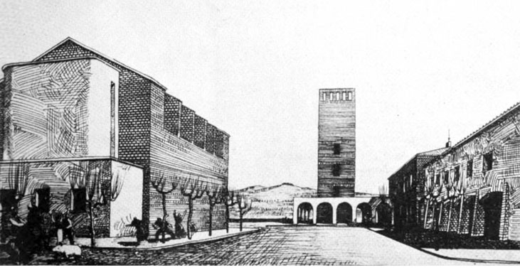
Fig.
1b - Pomezia’s Master Plan Petrucci by Tufarolli, Paolini,
Silenzi, (from L'Ingegnere 1938).
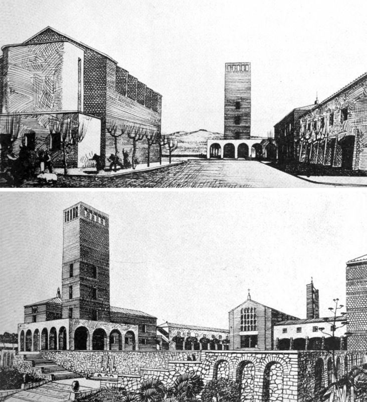
Fig.
2 - Reclamation Authority, Capograssa village, the tower/reservoir
project, elevation and section, 1929.
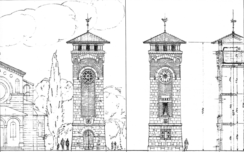
Fig.
3 - Pontine Land Reclamation Authority, Casal dei Pini Village (later
Borgo Grappa) under construction, water-tower in the foreground, 1930.
Fig. 4 - Agro Pontino Reclamation Authority, Picture of Borgo Montenero
water-tower shaped as fasces, 1930.
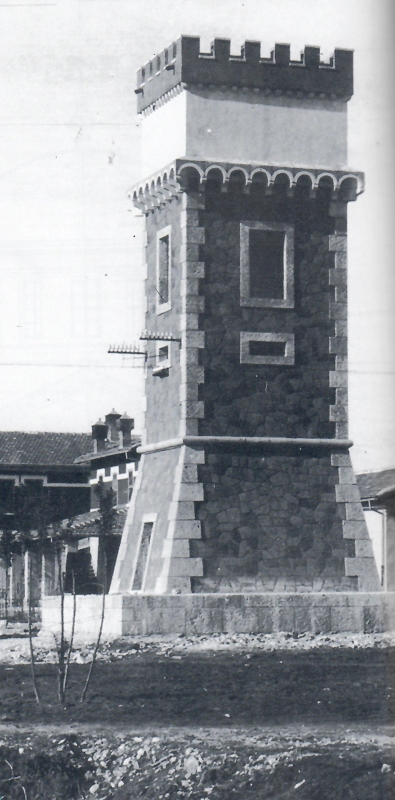
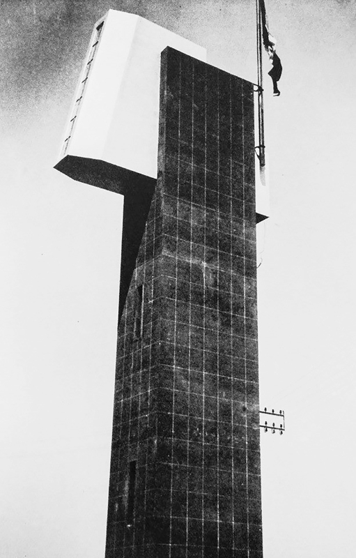
Fig.
5 - Adalberto Libera and Mario De Renzi, Italian Pavilion at Chicago
World's Fair, USA, 1933. Photo of the model (from Architettura 5, 1933).
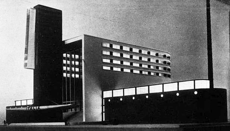
Fig.
6 - Water-tower-granary silo in Latina (demolished).Photograph (from La
nuova città di Littoria nell'Agro pontino, Architettura 2,
1933).
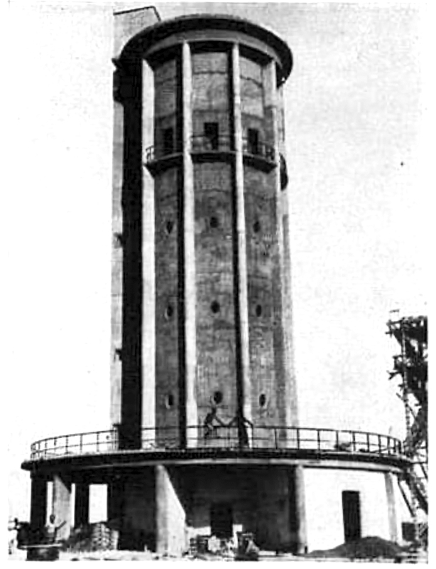
Fig.
7 - Littoria water-tower-granary silo. Postcard, post-1945.
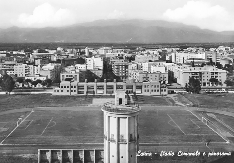
Fig.
8 - Oriolo Frezzotti, Sabaudia’s water-tower. Photograph
(©Archivio fotografico storico, Istituto
Superiore di Sanità).

Fig.
9 - Sabaudia’s water-tower and Viale Biancamano. Photograph
(from Sabaudia Amarcord, Facebook page; downloaded 23 July 2022).
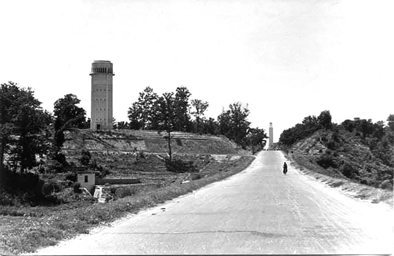
Fig.
10 - Oriolo Frezzotti, Pontinia aqueduct reservoir tower. Photograph
(©Archivio fotografico storico, Istituto
Superiore di Sanità)
So, it is evident that all those subjects that we have
excluded from architecture proper - bridges, obelisks, fountains,
triumphal arches, clusters of trees, etc. – actually are all
part of urban spaces. Facades in particular come all into play in the
formation of urban spaces (Zevi
1948, p. 28).
Referring to Portugal, the historian Tiago Saraiva (2009) emphasises
the convergence between internal colonisation projects and the
frontier. According to him, the policies aiming to modernise the rural
landscapes and extend the cultivated lands accelerated the synergies
between engineering, technology, planning and architectural
experimentation within the nation-states.
Frontiers between untamed nature and the man-made environment were a
common feature of several European countries at the beginning of the 20th
century, yet these frontiers were imaginary constructions, especially
in the political narratives of totalitarian regimes, where
technological innovations supported the creation of new settlements,
also underpinning the representation of an emerging society.
When we think about the frontier, the image of rarefied landscapes
often comes to mind: roads covering great distances, orderly
settlements alternating with isolated buildings.
The century-long European colonial experience imparted into the
general culture the need for seizing the frontier through the
construction of new towns, qualifying them as embryos of a new social
order (Nicolini 2006). Geometry, abstraction and grids indifferent to
topography (Culotta et alii 2007) dictated urban and territorial
settlement schemes as an attempt to match the ideal society newly
established.
A possible common denominator between colonial ventures and 20th-century
inner colonisation schemes lies in the presence of a military matrix
aimed at controlling the territory, allied to a figurative abstraction
of the urban layout. Farmhouses, farms, stables, warehouses and sheds
thus became the object of constructive experimentation, setting the
ground for repetition and typological inflections.
A rising technical landscape
It is no surprise that the military metaphor recurred so often in the Fascist propaganda[1]
(Mussolini 1932, p. 3) about the hydraulic reclamation of the Pontine
Marshes. Taming the marshes – dubbed 'branch of hell' (Savinio
1936) - was like a warfare, entailing recruitment of workers from afar,
great manoeuvres of machinery, and daily duties to advance through the
marshes (Cencelli 1935, p. 162). The logistics of reclamation resulted
in a network of roads, electrified lines, canals and water machines
superimposed to the former marshes, featuring altogether what can be
defined as technical landscape (Selvafolta 2001).
The importance of this frontier was such that, before reclamation
(Armiero et alii 2021), the marshy and wooded areas of the Pontine
Plain resulted as uncharted; when the newly built roads reconnected
Rome with the plain, the Fascist party advertised it as a restitution
of a piece of motherland which materialised into a new Cartesian
network of roads and canals hinged onto the ancient Appian Road.
Roads, canals and windbreaks were all elements of this technical
landscape that integrated natural elements and artificial networks,
meant to make the plain productive and settle the local rural
population erasing all traces of pastoralism. To curb massive migration
towards the cities, the regime enacted rural policies that relied on
technology; this, however, caused an increase in the industrial
production of seeds, fertilisers and agricultural machinery (Caprotti
2007).
Along with the productive aspect of the rural production,
modernisation implied the distribution of electric light and running
water for the residing population. The networks of modern cities
(Graham 2001, p. 10) and the technical artefacts assumed an iconic role
in the new countryside of the 1930s[2].
According to Kaika and Swyngedow (2000), the urban transformations of the 18th
century marked a new approach to networks and related buildings which
became 'material shrines of progress' in the urban landscape. In many
cases, these buildings, despite their limited accessibility had a
figurative intent and were designed to be seen from the city,
contributing to the 'civic magnificence' of public spaces[3].
Seen from the countryside, the architecture of the water towers
emphasised the grandeur of the hydraulic works that could be hardly
embraced with the eye, as they originated elsewhere and stretched
throughout the whole territory. On the other hand, their towering
figures contrasted with the historic city, thereby heralding the
modernity of a device that enabled new lifestyles.
These technical artefacts may be considered architecture of public
utility and help us disentangle the evolution of the notion of
modernity, whereby technology and architecture complemented each other.
Towers
A water-tower is an elevated reservoir in compliance with the laws
of gravity, as water from a higher point can be distributed with
increased pressure to several lower points simultaneously. Piezometric
towers work on the same principle and provide a more capillary
distribution even within multi-storey buildings. Through a pumping
station at the base of the tower, water is captured (from a well in the
ground or from an aqueduct) and then piped to the upper reservoir.
Another feature for the piezometric towers is that it sets a
height-rule for the settlement as towers must be at least as tall as
the buildings they serve; through a system of pressured secondary
pipes, stored water reaches individual houses, even those with several
floors.
Initially water towers were built in the suburbs of industrial
towns, near railway stations or along the tracks to provide a supply
for steam locomotives; subsequently towers reached out residential
areas.
Fascist propaganda used water as a metaphor for the redemption of
the land: the regime had injected some orderly movement in the chaos of
the swamp (Cavallo 2016), stagnant water was pumped, channelled into
linear canals towards the sea; on a smaller scale, machines released
underground water and tapped it in reservoirs at the very core of the
new settlements.
The proximity between water towers and the urban fabric established
a field of experimentation for both engineers and architects. Engineers
sought to build lighter and bolder lifting structures (Fasoli 2012),
redefining the shape of the reservoirs with respect to different
lifting systems and local climatic conditions. While engineers
struggled to refine the structure of the shaft and shape of the
reservoir, architects thought about a shape that would harmonise with
the surrounding context; they even ventured to embed the tank and the
tubes within historical buildings as in the towers of Milan's Castle by
Luca Beltrami (Di Biase 2016).
In the design of a piezometric tower, technical constraints dictated
the structural solution, a precondition to envisage the overall form.
If, as a general rule, gravity influences the functioning scheme of a
water-tower, aspects such as position, orientation and its overall
height depend on topological conditions, such as the access to water or
the availability of electricity to activate the pumping system;
moreover, the size of the reservoir depends from the number of users
and the estimated consumption per unit. While defining a benchmark, all
these parameters leave some freedom as far as the body of the building
is concerned, from the basement to the top element.
Formal outcomes are manifold, lending themselves to different
interpretations of the building’s urban and landscape role. The
metaphor of the shell is not out of place when we consider water tower
architecture.
Water-tower design opened up a field of spatial and expressive
experimentation for architects, in the attempt to move beyond mere
engineering and standard solutions established by railway needs[4].
What we refer to as the «sculpted shell» (Ippolito 2003, p.
41) is actually the enveloping façade of water towers designed
with figurative references to mechanical components, the diversified
use of cladding materials along with chromatic quality and other
features that loaded the public spaces with a renewed sense of civic
decorum (Theseider-Duprè 1929).
Between Utilitarianism and Representative Instances
In the late 1920s and throughout the 1930s, piezometric towers were a recurring design theme for a number of young architects.
Angiolo Mazzoni’[5] was a
prominent designer of water towers and he usually conceived them as
cylinder structures with coplanar shaft and reservoir; this rendered
them “metaphysical solids” standing out from the historic
urban fabric.
The «aspiration to modernity» (Godoli 2003, p. 21) can
be detected by the choice to position the inspection staircase outside
the tower. This led to shrink the diameter of the tower while allowing
a 360-degree view of the surrounding landscape. Dedda (2017, p. 110)
noted that: «In this way a bond established between the building
and the context is set [...] it admits a new sequence:
building-man-landscape».
The isolated position of Mazzoni’s water-towers offered a
dynamic reference, perceivable from afar at a speed set by the modern
means of transport.
The 'urbanisation’ of water-towers meant that purely technical buildings[6]
acted as vertical landmarks of new public spaces. The composition by
‘contextual adaptation’ influenced the architecture of
water-towers, shifting the focus from the building itself to its urban
relationships at different distances.[7]
The solutions adopted for the design of façades as sculpted
shells and non-technical spaces within the water-towers triggered
architects to move beyond handbook solutions.
The issue of the façade was to be faced in a way to avoid any
meaningless decorative aspect (Group 7 1927, p. 468). On the other
hand, the limited number of public buildings forming the core of the
new-towns rendered technical artefacts part of the urban composition
and civic decor. Designing new public spaces or re-designing existing
ones meant harmonizing them with the surrounding context.
From a formal point of view, ‘setting-in’ a building was
a basic problem for any young architect trained under the supervision
of Gustavo Giovannoni at the Regia Scuola Superiore di Architettura in
Rome. This is where many of the planners of the new towns in Italy and
the colonies came from: personalities like Luigi Piccinato[8],
Angiolo Mazzoni and Concezio Petrucci, who embodied the figure of
'integral architect' in line with Giovannoni's concern about the
importance of controlling the impact of individual interventions, be it
monuments or ordinary buildings. According to Paolo Portoghesi (2019,
p. 9), the culture of ‘setting-in’ marked an important
advancement, as «architecture is not just about grandiose
monuments, it is something very different. It has the city as its
background, not only as a set of buildings but also as a
landscape».
Giovannoni's influence on the planners of the new towns cannot be
demonstrated through documents; yet, in the design proposals for the
partial demolition of historical city centres by Giovannoni and his
pupils, we may find some resemblance with the new-towns. Considering
the layout of these centres and their actual townscape as perceived, we
might venture to identify Fascist rural town with its centre, featuring
the grand urban-architectural composition.
In this case no demolition was needed to improve the overall townscape perception.
Squares resulted from the streets staggered layout, orienting the
viewer’s perception towards the tallest buildings (bell tower,
civic tower, Littorio’s tower) and filtering the view of the
surrounding landscape with porticoes and monumental portals[9].
The combination of multiple street directions and the 'accidental
effect' of the built ensamble was enhanced by the interplay of volumes
with different heights and façades, where towers acted as
landmarks, either marking a corner volume or the final point of a
central perspective[10].
In the new-towns designed by Concezio Petrucci towers acted as
backdrops of distant views, recalling the territorial impact of
Mazzoni's water-towers[11]. This
hypothesis seems to be supported by the fact that the main public and
service buildings, such as the Casa del Fascio, the Municipality or the
headquarters of the ONC (Ex-Servicemen organisation), were
characterised by an architectural language blends monumental elements
with others taken from minor architecture, not necessarily local,
reinvented to recreate a «remote and domestic otherness»
(Culotta et alii 2007, p. 37).
In the case of Pomezia, the last new-town built in the Agro Pontino,
the convergence between technical and representative aspects culminated
in the central water tower. This building in fact is at one and the
same time a torre littoria (the tower of the Fascist party)
and a civic tower facing onto the main square. The tower was conceived
as an autonomous volume, slightly offset from the town hall, at the
corner between the main square and the large avenue linking Latina to
Pratica di Mare. At the ground level the tower is connected to the
neighbouring buildings with a portico surmounted by a terrace. The
tripartite composition of the elevation reflects the building
programme: the portico at the ground level leads to the circular
staircase connecting all levels; the three-storey shaft is punctuated
by single-lancet windows and stringcourses, the top element is a
panoramic terrace. The prevailing impression is that of a sculpted
element with building volumes carved out from a solid block.
Water-towers in the villages and towns of Agro Pontino: a repertoire of images.
The technical office of the ONC - a laboratory (Cucciolla 2006, p.
213) where architects designed both towns and farmland – managed
to produce original designs for technical artefacts, epitomising the
notion of hybridisation between engineering and architecture.
Being the Pontine Plain a highly artificial landscape where
technology underpinned the re-creation of a 'second nature', hydraulic
works such as canals, pumping machines and even water-towers were key
artefacts allowing for the permanent residence of farmers. In fact,
water towers were part of a widespread network bringing a modern
commodity from the cities to the countryside.
Just like for Pomezia[12],
where the water tower was the tallest building in the main square, in
the workers' villages built by the Land Reclamation Authority the
provision of services was based on criteria of rationality and economy.
The village of Capograssa[13], built on the extension of Migliara 43[14]
served as a logistical centre for workers involved in the excavation of
the canal Collettore delle acque medie, the widening of the Sisto River
and construction of roads. The building site appeared as a
battleground: hastily built shacks, makeshift public buildings with
basic functions[15], and a dense
network of narrow-gauge railways that could be easily dismantled and
rebuilt on other working sites. Situated at the crossroads of drainage
roads, the village core was dominated by vertical buildings. The water
tower - with an electric cabin underneath - acted as a temporary bell
tower of the adjacent chapel, while a 30-m antenna with a balloon
served as a landmark for tracing the road in the season when the
vegetation was particularly dense.
The construction of the church in 1931 started the metamorphosis of
the workers' village into a rural centre. Completed in 1933, Borgo San
Michele and its water-tower epitomize the formal and functional
hybridization of utilitarian buildings. The water-tower with a clock
facing the square is entirely disguised under a 13.80 m tuff cladding
whose decorative elements echoed the church façade.
Given the overall extent of the reclamation project and the
pervasive network of roads, water-towers were ‘set-in’
against a wider context. It may suffice to consider the tower that
still overlooks the intersection of the coastal road with Migliara 45.
This was the water-tower of Casal dei Pini, a logistic centre for
reclamation workers. When the place was converted into a rural village
and renamed Borgo Grappa, battlements, buttresses and corner ashlars
were added to tower’s outer shell making it a copy of the Torre
Olveola, an ancient watchtower part of the coastal defence system of
Latium.
Borgo Montenero’s water-tower near San Felice Circeo was built
after 1933. In this case, the 'cubic form of architecture for energy '
celebrated by Marinetti (1935, 136) was replaced by a fascio littorio
(fascist beam) of 21.2 m. The 15 m-high shaft contains a staircase
reaching the top reservoir cantilevering onto the square. The
intersection of the two volumes is a blatant symbol of the Fascist
party, recalling temporary propaganda structures or exhibition
pavilions, such as the Italian pavilion designed by Libera and De Renzi
for the 1933 Chicago Fair.
In Borgo Montenero the water-tower is a tall, isolated building
hinged onto the urban layout. The village was described as a squared
plan, divided into three rectangular sectors with the smaller side
facing the main road. The central portion - the narrower – is
bounded by two N-S roads and a W-E green axis linking the main road to
the piazza with a garden at the opposite side.
The backdrop of the green-axis is the axe-shaped tower with a
reservoir at the top, making it a unique among other ones in the rural
villages (Pennacchi 2008, p. 233). Its highly expressionist outer shell
makes it the protagonist of Borgo Montenero’s public space and a
visual element along the road towards the sea.
The axe over a bundle of wooden rods – the fasces – was
the symbol par excellence of the Fascist party and the ultimate example
of the so-called 'politics of the visible' (Culotta et alii, 2007)[16]:
society and politics were to be re-shaped through the re-shaping of
formal features of the built environment; for this, public buildings
were characterized by elements recalling the fasces either literary or
in more abstract forms.
In many cases, the towers themselves were assimilated with the
figure of the fascio to the point that the vertical shaft and the
plasticity enhanced by the shadow cast on the areas in front of them
was used to enhance visibility from great distances, including the
vision from the airplane. Visible from afar from several points and
when driving a car, the water towers were ever-present in the everyday
life of rural settlers conveying a sense of modernity as conquest and
domestication of the frontier.
The sculpted outer shell is a distinctive feature of technical
artefacts as these buildings tie together both the territorial scale
and the urban one. Referring to aqueducts, Vittorio Gregotti wrote:
«the design of the building and its form enshrined the
interdependence between nature and settlement 'through the cleverness
of building'»(1994, p. 5)
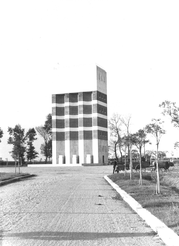
In the first three new-towns, Latina (1932), Sabaudia (1933) and
Pontinia (1934), water-towers were placed at the edge of the
settlement, near agricultural areas and main access roads. As for the
workers' villages turned into agricultural centres, in the new-towns
these buildings provided an opportunities for functional hybridization
and architectural experimentation. For example, in all three cases, the
functional tripartition of the water machine was variously interpreted
in the envelope, providing gathering areas or elevated observation
points. The design of the three water-towers was entrusted to Oriolo
Frezzotti (1888-1965), acting either as main architect or as consultant
for the urban plans of Latina and Pontinia and for the designs of
public buildings.
In the case of Latina, the water-tower originally appeared as an abstraction of fasces.
Base and shaft were two overlapped cylinders of different heights; a
third parallelepiped volume with the staircase connected the ground
floor to the top. The cylinder at the base, a very flattened monolith
with ten circular columns, engulfed a series of walled storage rooms
facing a semicircle on a porticoed area. The roof terrace above
overlooked the countryside and the stadium, allowing a 360 degrees view
of the city and the reclaimed plain.
The tower’s middle portion, a 12 m high shaft, was made of
reinforced concrete pillars set on the perimeter and partially embedded
in the outer façade, so as to create the illusion of the bundle
on the fasces. Inside it contained a grain silo that could be accessed
and filled at various heights; above there was the water reservoir.
Located just outside the stadium, in between the football field and
the crops, Latina’s tower may well depict the dual character of
technical artefacts, acting as landmarks for people driving along the
coastal road and those moving along any urban axis.
Sabaudia’s tower is another example of functional
hybridization featuring an iconic reshaping of its shell. Like the
water-tower of Latina, the tower cylinder shaft included a three floors
silo and a water tank with a capacity of 360 cubic metres; a dedicated
pumping machine was located at the ground floor. In this case, the
enveloping structure was a double shell enclosing the functional core.
This created a ring-shaped cavity of approximately 70 cm where the
staircase was built. It connected all the levels of the silo providing
a stiffening structure. In the gap between the functional core and the
perimeter wall, there is a ring staircase reaching the circular terrace
at +20.40 m above sea level (used for tank maintenance). The envelope,
from the machine room to the tank impost, was carved with flat-edged
grooves 15 m high to mark the shaft. The contrast between the solid
parts and the chiaroscuro effect of the grooves made the tripartition
legible and alluded to the rods of the fasces. The functional nature of
the water-tower is once again reinterpreted in a monumental key: a
large rectangular water basin (21 m x 13.50 m) with a blue mosaic at
the bottom alludes to the fountains and lavatories of the rural world.
Despite its monumental design, the tower was not part of
Sabaudia’s core. Its offset position on a hilly area made it a
landmark for those driving along Migliara 53. The water-tower marked a
threshold between the territorial stretch of Migliara 53 and its urban
continuation ending into the municipal tower on the main square. The
overall urban design can be described as the final crossing of Migliara
53 with an orthogonal system of squares opened towards the main
landscape features of the surrounding.
Concerning the architecture of water towers as part of a wider urban
design project, Pontinia’s tower well exemplifies what ‘in
the round’ means. This concepts delves into art and it is a nod
to the ‘in the round’ sculptures, which are freely designed
structure conceived in such a way allowing viewers to appreciate its
all-around by seeing it from different positions; even their position
invites it to be seen from certain points over others.
Pontinia’s water-tower is a parallelepiped (14m x 8, 50m)
28.50m high located on the banks of the Sisto river. From the technical
report it emerges that this solution depended on the shape of the tank
and the structure required to bear its load[17].
The structure is a framework of 12 reinforced concrete pillars
connected by 8 orders of beams cladded by stone-brick mixed
façades. From outside, the frame structure is not visible and it
is further hidden by the alternating horizontal travertine bands which
convey the image of a continuous load-bearing wall, almost as if it
were a fragment of a larger fortified structure.
The façade facing the central square to the north-west is
conceived as an excavated a built mass: three niches define the shaft
of the reservoir above like the giant order of an ancient monument;
each niche accommodates a spout at the base feeding the basin in front.
Seen from a foreshortened angle, the interaction between the jet of the
gush and the verticality of the niche recalls the shape of an inverted
fasces.
Pontinia’s water-tower contradicts the peremptory layout of
the central square: its offset position and the slight rotation
qualifies it as an outstanding building within the axial layout of the
new-town. The tower is an edge of a trapezoidal geometric composition
that combines the geometry in plan – mainly the central axis of
the square and the course of Sisto River - and the perspective features
emphasized by the elaborated façade.
The final effect of this rotation – unprecedented in other
new-towns of the Pontine plain – provides a simultaneous
corner-view of two façades, one from within the city and the
other from the countryside when moving along the roads. The unfinished
project of the picturesque promenade along the Sisto River would have
enriched the spatial sequence between the river and the city by making
the tower-tank visible from all sides, a solution that reinforces not
only the hypothesis that the ‘setting-in’ of technical
buildings in rural new-town was a key symbolic construction as part of
the frontier narrative.
Even today, when reaching the terrace above the travertine top
volume, the experience of the frontier persists in the dialectic
between the territorial scale of the reclamation project, visible in
the linearity of roads and canals crossing the plain, and geographical
counterpoints such as Cape Circeo and the coastline to the west, the
Appian Way and the Ausoni-Lepini Mountains to the east.
Concluding remarks
Despite Giuseppe Pagano's critical stance[18]
about Pontinia's urban project as a missed opportunity, one cannot
ignore the architectural and urban quality of the water-towers in the
rural world. These towers are examples of an unprecedented degree of
formal and functional hybridization.
The result - at times modest or magniloquent - is the statement of a
principle: architectural design should not shy away from expressing
figurative choices even when size, location and use are purely
utilitarian.
By broadening the spectrum of analysis on the modernisation of rural
landscapes and new-towns we inevitably might confront the idea that
«agriculture is an industry that does not yet know it is an
industry» (Studiati 1930, p. 783) meaning that the role of
technology and structures built to sustain either agricultural
production or the artificial landscape is fundamental.
The examples from the pontine plain help expand the field of
histographic boundaries and venture into future challenges. In fact we
might see a lasting challenge concerning the coherence between
architectural design and aspects of technological operation which are
often eluded by the entrenchment within disciplinary boundaries. Today,
buildings which house or sustain specific technologies, logistics or
energy production are dramatically over-simplified by repetition, and
standardisation of construction systems that almost completely avoid
functional hybridisations as a field to develop formal and spatial
complexity.
In spite of the obsolescence (Abramson 2016) of the technological
networks and supply system and the replacement of the water
distribution in the cities of Agro Pontino, the inoperative
water-towers still provide a visual element that helps restore the
interplay of perspectives and views dating back to foundation.
We might ask ourselves if the present-day utilitarian buildings - so
dramatically exposed to faster technological innovations, shorter
obsolescence phases and with ever more limited frontiers to be placed
– will sooner or later become architectures of waste, alien to
contexts and precarious in terms of identity.
Assuming that one of the future tasks for architects will be to
design productive or utilitarian buildings, one wonders how
architectural design can still express its ability to orchestrate the
spatial organism without being merely a container.
The study of Italian rural modernism and the 'setting-in' effort of
the water towers shows how public buildings, minor architectures and
even those structures supporting technological innovations contribute
equally to the formation of the built environment.
[1] Corrado Alvaro (1934, p.47)
also applied the war metaphor when he described reclamation. He wrote:
«It must never have happened to see in such a short time, and
from day to day, such a vast and complete transformation of the earth
[... ] perhaps in the phenomenon of war, when a meadow in a brief hour
would change physiognomy, and the two or three thousand men who
occupied it, each for himself and for all, would transform it into an
encampment with tents, drains for water, a kitchen, clearings, offices;
or rather, on the battlefield, when the elements of destruction were
combined with the work of man, the land would change its appearance
down to its very heights and a gigantic city of cave dwellers would
emerge with the rapidity of the work of the termite mound».
[2] The cultural geography Maoz
Azaryahu (2019) analyses the role of piezometric towers in Zionist
rural settlements, observing their evolution from icon-buildings of
progress to actual memorials of the Israeli War of Independence.
[3] Italian examples include
the Cisternone (1829-1842) in Livorno designed by Pasquale Poccianti at
the head of the aqueduct derived from the Monte Colognole springs. The
façade is characterised by a Tuscanic colonnade surmounted by a
large spherical section. a series of smaller pavilions, casotti served
to regulate the flow of water. Another example is the aqueduct in Lucca
designed by Lorenzo Nottolini, which arcade ended with two monopterial
temples surmounted by a drum and dome: one at the Guamo springs and the
other just outside the city walls. According to Matteoni (2001, p. 83),
this form made explicit the public destination of the building and can
be referred to the projects of Boullèe and Ledoux. In some
cases, such as the London sewage works (1864-1874),
sewage filtration stations also took on a monumental character;
these were two iron and brick buildings designed to lift sewage to
facilitate its outflow. The waterworks at Crossness recalled elements
of Romanesque architecture while Abbey Mills was inspired by
Neo-Byzantine architecture.
[4] Biagini and Nuti (2003)
identify a transitional phase for the development of railway
architecture in the transition from the use of coal-fired locomotives
to the electrification of the national network, which made many
buildings obsolete, while new ones such as central apparatus cabins,
electric traction depots and workshops were built.
[5] Angiolo Mazzoni del Grande
(1894-1979) worked in the Technical Office of the State Railways where
he designed many stations, as well as numerous postal buildings. After
the fall of fascism Mazzoni moved to Colombia (1947-1963) and then
returned to Italy for good. In Agro pontino he designed the Latina
Scalo station (1932) and the post office buildings in Latina (1932) and
Sabaudia (1932-1934).
[6] See Maltoni (2013) and
Ciccarelli (2014). The piezometric tower in Forlimpopoli is an
emblematic example of a hybrid typology. The basement was conceived as
a chapel and then as a war memorial. In the case of Osimo, the
reservoir tower designed in 1933 to replace the pre-existing one
initiated the reconfiguration of the square in front of it. In
contiguity with the Romanesque church of San Leopardo, the tower was
likened to a bell tower. Many piezometric towers built during Fascism
have been imagined as littoral towers, the monumental Fascist building
par excellence.
[7] In describing the Aprilia
plan, Concezio Petrucci (1902-1946) emphasised its scenic effect:
«The plan extends on a pleasant hillock, from which one can
observe the exceptional panorama of the Colli Albani to the north, the
chain of the Monti Lepini to the north-east and to the south-east the
characteristic outline of the Promontorio del Circeo, which is drawn
sharply on the horizon, like a gigantic bulwark that seems to protect
the marvelous reclamation that only Mussolini's men were able to carry
out»(Petrucci, 1937, p. 19 ). The square in Pomezia, on the other
hand, is described as «closed on three sides, it opens up the
fourth like a wide terrace, facing the clear horizon of the surrounding
countryside with the cerulean shadow of the Albani mountains as a
backdrop» (Patti 1938, p. 96).
[8] Although he was not a pupil
of Giovannoni, Luigi Piccinato made some of the most innovative
concepts his own; in particular the idea of the city as an organism in
which the relationship with the 'new building' was played out (Pane
2015).
[9] In the new-towns, portals
and arcades connected individual public buildings, delimiting the space
of the square. In the sanitation project for Bari Vecchia (1932),
Concezio Petrucci «continues to pin architectural elements
typical of replacement buildings that are, to a large extent, necessary
to suture the wounds caused by demolitions during the sanitation
project» (Cucciolla 2006, p. 127)
[10] In a way entirely
similar to the examples of historic Italian cities and in particular in
the interpretation that Giovannoni and his students made of them in
their sanitation projects which included demolition and rebuilding.
Petrucci's project for Bari Vecchia, in this sense, is the most
«accomplished and organic example of the application of the
theory of building destruction for sanitary reasons» (Cucciolla
2006, p. 135) since it identified the Norman bell towers as the visual
catalyst of the intervention, i.e. points of monumental concentration
with respect to a minor building fabric. (Moschini 2019).
In the thinning plan for old-Bari, the demolition of buildings or
parts of them to free up the crossing axes also has an 'artistic'
purpose: it is the cathedral bell tower that is the goal and visual
backdrop of all the planned streets.
[11] Cucciolla (2006, p. 245)
writes: «The civic tower plays, together with the bell tower, the
oft-referenced role of compositional pivot of the entire project and
primary visual emergence; the tower is resolved as a compact volume,
devoid of openings and made up of a Marino tufa wall, elegantly
subdivided into modules by a thin incision [...]». And more:
«Petrucci uses the cathedral bell tower, which constitutes the
highest architectural emergence in Bari, as the main visual goal for
the user and as the pivot of the urban reconfiguration, according to
scenic criteria that may even make one think of Baroque suggestions or
Haussmann-esque citations» (ibid., 126).
[12] Designed by architects
Concezio Petrucci, Mosè (Mario) Tufaroli Luciano and engineers
Filiberto Paolini and Riccardo Silenzi. The group built three new towns
on behalf of the ONC: Aprilia (1936), Pomezia (1937), Fertilia
(1937-1943); Petrucci would design Segezia (1939-1941) while Paolini
and Tuffaroli would design Borgo Appio and Borgo Domitio in Campania in
1939.
[13] The fifth to be built by
the Piscinara Reclamation Consortium after Sessano, Passo Genovese,
Casal dei Pini and Doganella (Paradiso and Vittori, 2002).
[14] Migliara 43 was laid out at the end of the 18th century in the context of Pius VI's land reclamation
[15] The collective
facilities included a school with accommodation for the teachers; a
health centre with doctor's quarters; a cinema and after-work club; a
building for the head of the Azienda Agraria temporarily used as a
technical office; a church, a police station, three blocks of flats for
the workers that could be converted into farmhouses, a food pantry, a
collective bakery, three fountains with drinking troughs and a lavatory.
[16] The symbol of the fascio
littorio did not only represent the Fascist party. It represented the
new values advocated by Fascist Italy. From 1927, the fascio became the
State coat of arms. From 1929, two fasces flanked the coat of arms of
the Savoy family. The fascio littorio also became the symbol used on 1
and 5 lire stamps (Falasca-Zamponi, 1997, p. 99)
[17] The technical report
states: «Assuming a stable population of 5,000 people and a per
capita use of 100 litres of water, the expected average daily
consumption is 500,000 litres, to be met, during the period of maximum
consumption, by filling the reservoir three times a day. The reservoir,
with an almost square cross-section, measuring 4.5 m by 4 m and a
length of 10 m has a capacity of 180 cubic metres».
[18] Pagano (1935, p. 6)
wrote in Casabella: «Pontinia does not lack even some vague
fluttering in its frame, some picturesque and seductive elements. It is
enough to look out over the riverbed where the river, laid out by
Ascanio Fenizi by order of Sixtus V and arranged and corrected by the
Fascist land reclamation, flows to foresee the urbanistic use that can
be made of that watercourse. The Sisto, in its regular banks, also has
the width and serious quietness of the canals of Padania. A tree-lined
road will run, in the direction of the river, and it will be Pontinia's
Lungosisto. On warm nights, groups will go for a walk along the
embankment, just like the villages in the po valley»
References
ABRAMSON D. (2016) – Obsolescence. An
Architectural History. The University of Chicago Press,
Chicago e Londra.
ALVARO C. (1934) – Terra nuova. Prima
cronaca dell’Agro Pontino. Istituto Nazionale
Fascista di Cultura - Edizioni Novissima, Roma.
ARMIERO M., BIASILLO R. e GRAF VON HARDENBERG W. (2022)
– La natura del duce. Una storia ambientale del
fascismo. Einaudi, Torino.
AZARYAHU M. (2019) – “Water towers: a
study in the cultural
geographies of Zionist mythology”. Ecumene, (8), 3 (Luglio),
317-339.
BIAGINI C. E NUTI F. (2003) – “Tecnica e
forma nella manualistica
ferroviaria”. In: M. Cozzi, E. Godoli e P. Pettenella (a cura
di), Angiolo Mazzoni. Architetto ingegnere del ministero
delle comunicazioni, Skira, Milano.
CAPROTTI F. (2007) – “Destructive
creation: fascist urban planning,
architecture and new towns in the Pontine Marshes”. Journal
of
Historical Geography, 3, (33), 651-679.
CAVALLO F. L. (2016) – “Visions
littéraires des paysages de la
bonification en Italie”. Le Globe. Revue genevoise de
géographie, 156,
111-134. doi: 10.3406/globe.2016.7398
CENCELLI O. (1935) –
“L’organizzazione tecnica e agraria della
redenzione pontina”. In A.A.V.V., La bonifica
delle paludi pontine. Casa editrice Leonardo da Vinci, Roma.
CICCARELLI L. (2014) – “Innocenzo
Sabbatini e una torre per San Leopardo a Osimo”. In: Gallo A.
(a cura di), Dalla torre alla torre piezometrica.
Edizioni Kappa, Bologna.
CUCCIOLLA A. (2006) – Vecchie
città/Città nuove. Concezio Petrucci 1926-1946.
Dedalo, Bari.
CULOTTA P., GRESLERI G. e GRESLERI G. (2007) – Città
di fondazione e plantatio ecclesiae. Compositori Editrice,
Bologna.
DEDDA M. (2017) – Architettura [e]
Tecnica. Funzione Forma Valore delle architetture tecniche per le reti
infrastrutturali. Tesi di Dottorato, Università
La Sapienza Roma. [online] Disponibile a
<
https://phd.uniroma1.it/web/DEDDA-MARTINA_nP1154273.aspx>
[Ultimo accesso 02 giugno 2022]
DI BIASE C. (2016) – Strutture in calcestruzzo
armato nel castello
Sforzesco di Milano (1904-1956). [online] Disponibile a:
https://www.ingenio-web.it/5687-strutture-in-calcestruzzo-armato-nel-castello-sforzesco-di-milano-1904-1956
[ultimo accesso 10 giugno 2022].
FALASCA-ZAMPONI S. (1997) – Fascist
Spectacle. The Aesthetics of Power in
Mussolini’s Italy. University of California Press,
Berkley.
FASOLI V. (2012) – “The Porcheddu company
and projects for
reinforced concrete water tanks. Building models and construction site
experience (1912-1933)”. In: C. Piaton, E. Godoli e D.
Peycerè (a cura
di), Building Beyond The Mediterranean. Studying The
Archives of European Businesses (1860-1970).
Honoré Clair, Arles.
FERRI G. (2020) – Coming back to
fathers’ land: sense of belonging and search for the origins
(Giuseppe Ungaretti and Alberto Savinio).
Tesi di Dottorato, Laboratoire LUHCIE, Universitè Grenoble
Alpes,
Dipartimento di Lettere e culture moderne, Università La
Sapienza, Roma.
GODOLI E. (2003) – “La
modernità discreta di Mazzoni”. In: M. Cozzi, E.
Godoli e P. Pettenella (a cura di), Angiolo Mazzoni.
Architetto ingegnere del ministero delle comunicazioni,
Skira, Milano.
GRAHAM S. (2001) – Splintering Urbanism. Networked
Infrastructures, Technological Mobilities and the Urban Condition. Routledge,
Londra.
GREGOTTI V. (1994) –
“Editoriale”. Rassegna, 57 (marzo).
GRUPPO 7 (1927) – “Architettura
impreparazione-incomprensione -pregiudizi”. Rassegna italiana
serie II, (X), 19 (marzo).
HARVEY E. (2005) – “Managemnt and
manipulaion: nazi settlement
planers and ethnic german settlers in occupied Poland”. In C.
Elkins.,
S. Pedersen, Settler Colonialism in the Twentieth Century.
Routledge, New York.
IPPOLITO L. (2003) – “Struttura e
involucro nell’opera di Angiolo Mazzoni”. In M.
Cozzi, E. Godoli e P. Pettenella (a cura di), Angiolo
Mazzoni. Architetto ingegnere del ministero delle comunicazioni,
Skira, Milano.
KAIKA, M. e SWYNGEDOUW E. (2000) –
“Fetishizing the Modern City: The
Phantasmagoria of Urban Technological Networks.”
International Journal
of Urban and Regional Research, 24 (1), 120-139.
MALTONI C. (2013) – “Particolari
architetture tecniche in
Forlimpopoli: le “torri dell’acqua”
comunali tra ventennio e
liberazione”. Documenti e Studi, 24, 155-188. Disponibile
presso:
Rivista del Museo Archeologico “Tobia Aldini”
[online] disponibile a:
<http://www.forlimpopolidocumentiestudi.it/pdf/2409.pdf>
[ultimo
accesso il 02-06-2022].
MARINETTI F. T. (1935) – “Presentazione
delle sale futuriste. In: A.A.V.V, Seconda quadriennale
d’arte nazionale, catalogo della mostra,
Tuminelli, Roma.
MATTEONI D. (2001) – Pasquale Poccianti e
la Gran Cisterna di Livorno. Silvana Editore, Cinisello
Balsamo.
MOSCHINI F. (2019) – “Gustavo Giovannoni e
Concezio Petrucci”. In: G. Bonaccorso e F. Moschini (a cura
di), Gustavo Giovannoni e l’architetto integrale.
Accademia Nazionale di San Luca, 25-27 Novembre 2015, Roma.
MUSSOLINI B. (1932) – “La guerra che noi
preferiamo”. La conquista della Terra, 12, 3-5.
NICOLINI R. (2006) – “La città
della Bonifica Pontina come Modello”.
Archiettura Città rivista di architettura e cultura urbana,
14, 36-38.
PAGANO G. (1935) – “Architettura
nazionale”. Casabella, 85 (febbraio).
2-7.
PANE A. (2015) – “L’opera di
Piccinato tra continuità e rottura con
Giovannoni da Padova a Napoli”. In: Belli G. e Maglio A. (a
cura di), Luigi Piccinato (1899-1983). Architetto e urbanista,
Aracne, Ariccia.
PARADISO C. e VITTORI M. (2019) – Futuristi
nelle città di fondazione. Novecento, Latina.
PATTI V. (1938) – “Pomezia”. La
conquista della Terra, 2 (febbraio), 50-52.
PENNACCHI A. (2008) – Fascio e martello.
Viaggio per le città del Duce. Laterza, Bari.
PETRUCCI C. (1937) – “Aprilia la
prediletta del Duce”. Nazione e impero, 10, 17-24.
PORTOGHESI P. (2019) –
“L’insegnamento di Gustavo Giovannoni”.
In: G. Bonaccorso e F. Moschini (a cura di),
Gustavo Giovannoni e l’architetto integrale.
Accademia Nazionale di San Luca, 25-27 Novembre 2015, Roma.
ROCCATELLI C. (1938) –
“Pomezia”. L’Ingegnere, 4 ,156-164.
SARAIVA T. (2009) – “Laboratories and
Landscapes: the Fascist New
State and the Colonization of Portugal and Mozambique”.
Journal of
History and Technology, 3, 35-61.
SAVINIO A. (1936) – “Ritratto della grande
proletaria. Da Agro Pometino a Palude Pontina”. Il Lavoro
fascista, 28 Luglio.
SELVAFOLTA O. (2001) – “Il paesaggio
tecnico come giardino: ‘le
belle linee’ e le ‘scene variate’ nelle
strade dello Spluga e dello
Stelvio”. In: G. Guerci (a cura di), Giardini e
parchi di Lombardia dal restauro al progetto. Quaderni
d’Archivio 10, Cinisello Balsamo.
STUDIATI P. (1930) – “Gli orizzonti della
elettro-agricoltura”. L’Italia agricola, 12,
783-788.
THESEIDER-DUPRÈ E. (1929) –
“Sottostazioni tipo per linee elettriche
trifasi”. Rivista tecnica delle ferrovie italiane, 2, 53-64.
VITTORI M. e FEDELI L. (a cura di) (2002) – Borgo
San Michele già Capograssa. Novecento, Latina.
ZEVI B. (1948) – Saper vedere
l’architettura. Einaudi, Torino.