“Të bëjmë fshatin si
qytet!”
The urbanization of the countryside in socialist Albania
Federica Pompejano
Fig.
1 - Cover of the periodical Bujqësia Socialiste celebrating
the 30th years of Albanian Labour Party and the announcement of the
imminent ending of the electrification supply campaign in the country
expected in 1971 (Bujqësia Socialiste, 1, 1968, cover).
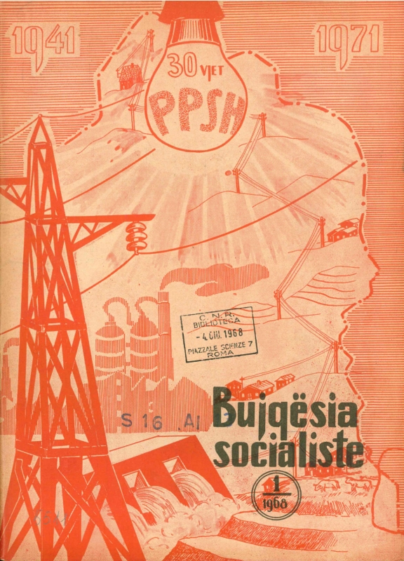
Fig.
2 - View of a new socialist rural village and a scene from a new
socialist rural life. The text in between says “New villages,
new people” (in 40 vjet Shqipëri socialiste - 40
Years of Socialist Albania, 1984, p. 92).
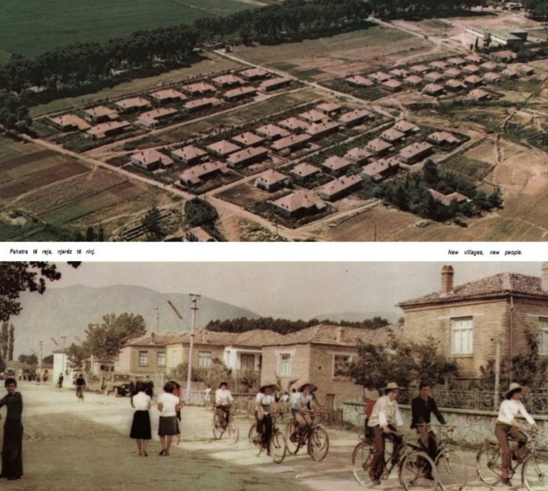
Fig.
3 - From left to right, example of rural housing in Rëmbec,
Korça district (row 1); ruins of the Museum of the Village
and the House of Culture in Rëmbec (row 2); agricultural and
livestock breeding buildings in the former economic production zone of
Rëmbec (Pompejano F., 2021, CC BY-NC-SA 4.0).
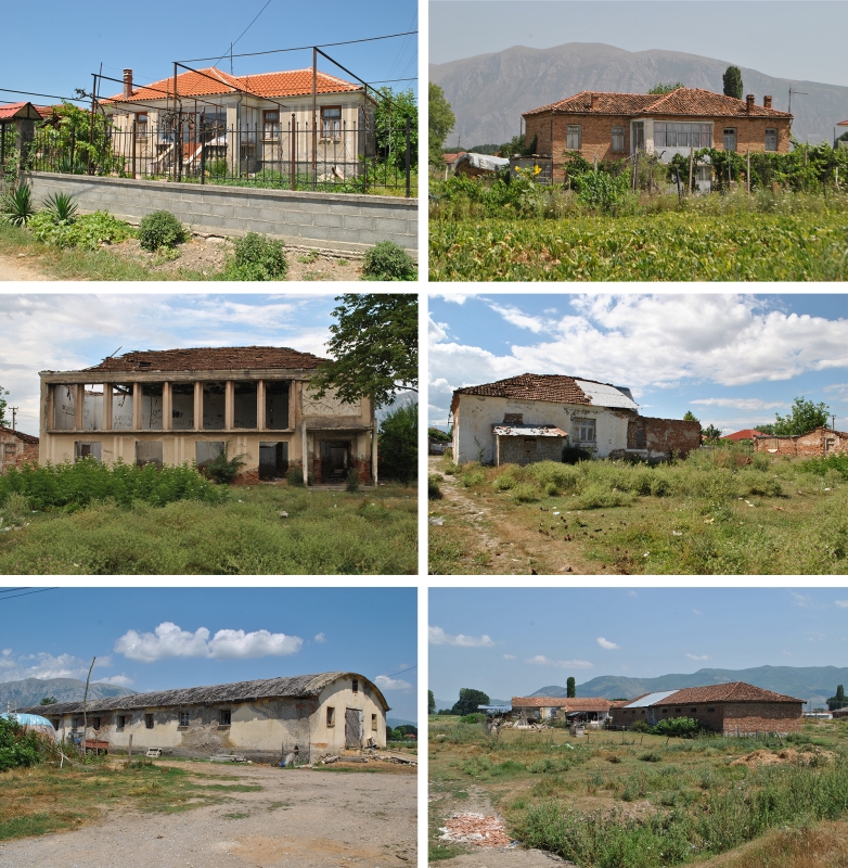
Fig.
4 - The arrangement of the rural buildings (Skica nr.1) and of the
zones composing the new Albanian socialist rural settlement (Skica
nr.2) according to the relief as for the 1961’s brochure
“Projektim Urbanistik i Qendrave
Bujqësore” (AQSHb 1961, p. 64/23).
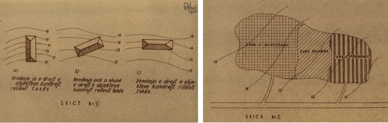
Fig.
5 - The residential individual plot or parcel (ngastër
individuale) according to the 1961’s brochure
“Projektim Urbanistik i Qendrave
Bujqësore” (AQSHb 1961, p. 64/29).
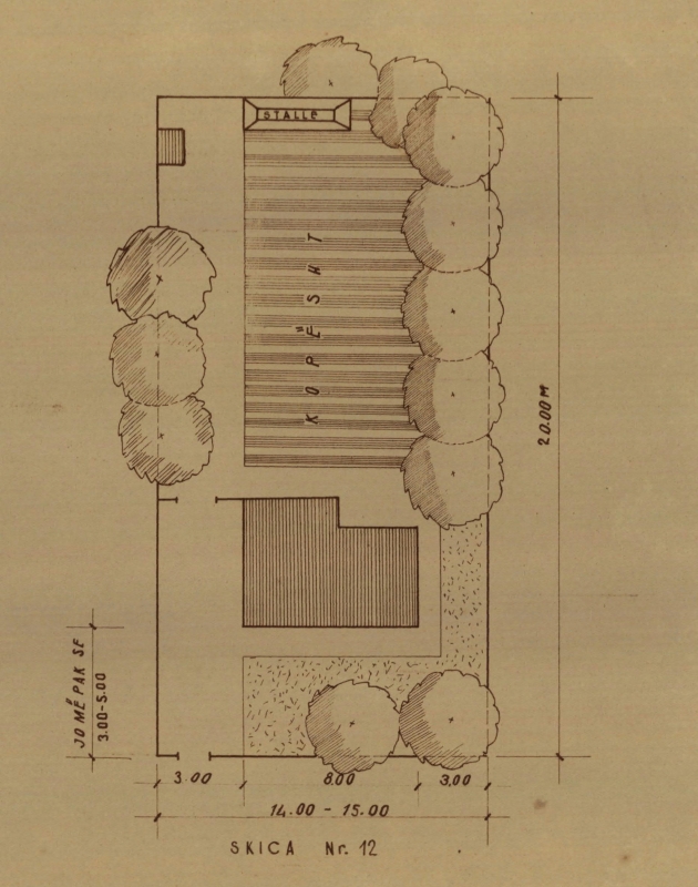
Fig.
6 - The arrangement of the service, breeding and production buildings
composing the production zone of the new Albanian socialist rural
settlement according to the 1961’s brochure
“Projektim Urbanistik i Qendrave
Bujqësore” (AQSHb 1961, p. 64/26).
After the Second World War, Albania developed a harsh
dictatorship converging in the socialist ideology. The country that
until then was considered the most backward European country with a
traditionally agrarian society (Kopsidis and Ivanov 2018, p. 36;
Brochert 1975, p. 177), started a rapid modernisation process that led
to the industrialisation and the urbanisation of the major cities and
the countryside. This development was sustained from the very beginning
of the dictatorship, by foreign help from the East European countries
and the Soviet Union. The new Albanian society inspired by the Soviet
model had space for two main social groups: workers and peasants, that
together with the intelligjencia, formed the
working mass of socialist Albania (Czekalski 2013, p. 82).
In August 1945, the Agrarian Reform Act introduced the
principle according to which «the land belongs to the person
who cultivates it» and allowed the confiscation of all large
properties including the ones belonging to religious communities. The
confiscated land was divided among the peasant families, that until
then, owned no or a little land. Meant as the first step towards the
new socialist life, the Agrarian Reform Act was the very first
social-economic scheme implemented by the regime. The implementation
had also a political and cultural impact on the peasant population. The
impact of political coercion was exemplified in the subjecting of the
mass to socialist ideology, underlining its close and direct
“democratic relationship” with the state (AQSH
1950, pp. 2-5). Cultural impact was reflected in the opening of schools
and public services, and in the great campaign against illiteracy. The
collectivization process went alongside the establishment of
cooperatives and state farms and was slow (Czekalski 2013, p. 72),
ending only in the late 1960s.
At the same time, the regime put further emphasis on bringing
more land under cultivation by reclaiming the swamp and marshlands
(Brochert, 1975, p. 181). The main swamps in the Albanian plains, such
as the ones in the Myzeqe Plain and Korça Plain, were
reclaimed and transformed into arable land and provided with a rational
system of water sources for irrigation purposes. By carefully looking
at the territory, it is possible to observe the extension of the vast
water network composed of pre-existing main rivers, waterways, and
lakes to which the regime added new water basins, canals, and
reservoirs. Following the reclamation of the marshy and saline lands,
many works of arrangement, embankment, or deviation of water courses
were realized by the technicians aimed at implementing the irrigated
surfaces. Furthermore, the hills and halfway mountainous profiles were
shaped in terraces that transformed the gentle slopes into bands of
arable and cultivated land from North to South, and mountain pastures
into cultivated fields.
In 1967, 730 villages were provided with electricity supply
(Instituti i Studimeve Marksiste-Leniniste 1974, p. 408) corresponding
to 29% of the rural villages of the country. The directives of the
Plenum of the Central Committee of Albanian Labour Party, held in
December 1967, anticipated the achievement of providing electricity
supply in all rural areas by November 8th, 1971;
a Party’s priority was already expected to be achieved in 1985[1] (Fig. 1).
In this context, the rural landscape, urban planning, and
architecture were placed in service of the industrialization and
urbanization that were implemented through development aid from the
Soviet Union until 1961, and thereafter from China until 1978
(Mëhilli 2017, 98).
Furthermore, in Socialist Albania issues of urban planning and
architecture were related to demographics forecast in view of the
prospective developments of industry and agriculture, cities, and
villages, yet conditioned by the economization of the productive and
arable lands and the fast-paced process of reducing materials and
construction costs.
The establishment of agricultural cooperatives
and state-farms in the new post-war rurality
Since the collectivization process began alongside the
Agrarian Reform’s implementation, the incessant propaganda to
produce the new modern society conditioned a socialist architectural,
construction, and planning code that led to the impellent urbanization
phenomena significantly reflected in the rural landscape. During the
implementation of the new socialist rurality, Albania adopted two types
of rural economies: the Ndërmarrja
Bujqësore Shtetërore (NBSH), i.e., the
agricultural and livestock state-enterprise or state-farm and the Koperativa
Bujqësore and Koperativa Blegtorale
(KB), i.e., the agricultural and livestock cooperative[2]. These
economic models reflected in two main types of rural settlements: the
new socialist agricultural centres built from scratch in reclaimed or
most suitable land, and cooperative settlements encompassing existing
villages as well as new agricultural centres (Faja, Sukaj and Shehu
1990, p. 4). Most cooperatives started on a village basis, but later
several settlements were combined to form bigger units. As Brochert
(1975, p. 185) reported, the number of agricultural state farms
increased from 13 in 1947 to 32 in 1968, whilst the number of
agricultural cooperatives, on the other hand, decreased from 1208 in
1967 to 643 in 1970 (Geço 1973, p. 37). This was due to the
impellent need to transform one of the two social forms of property,
i.e., the cooperative property, into state property by transforming the
major cooperatives into state-farms.
The collectivisation of the land and the mechanisation of the
agricultural sector led also to the rapid urbanisation of the
countryside. The latter covered a long span of time and was conceived
as a complex process strictly linked to and coordinated with the
socialist political ideology, the industrialisation processes, the
strengthening of the socialist production relationships, the
intensification of agricultural production, the country’s
electrification campaign, the implementation of cities’ urban
masterplans and the socio-cultural regime’s propaganda. The
socialist intent of reducing the differences between the urban and
rural areas converged into an effort for creating new socio-spatial
settlements for the new society to be built[3] (Fig. 2).
Therefore, the development of new rural settlements was a
pivotal element in the rural landscape transformation. The minor
settlements should have gravitated to the major ones and the major ones
should have been in connection with the main cities, trying to
materialise the communist system of economic, production, and
socio-cultural relationships that had to determine the functional
structure of the environment (Gutnov et al, 1968, p. 27). Hence, the
countryside’s urbanization process manifested itself in the
specific schemes and designs that the regime aspired to implement. The
establishment of agricultural cooperatives and state-farms economies
and the mechanization of agricultural production necessarily led to the
re-organization of the Albanian village. In this sense, of particular
interest are the agricultural settlements set up basing their design on
socialist rural planning principles with the intent to create and
strengthen the cooperation between the working class and peasants, by
narrowing the differences between towns and villages. As Londo (2022,
p. 26) pointed out «The identification of the spatial changes
following the principle of narrowing the difference between the city
and the village […] can be classified according to a
hierarchical system going from the macro-regional to the micro-local
scale». At the territorial level, the changing of rural
“space” was reflected in the development of
masterplans with the intention of ruling and organizing the new
post-war rurality and its relationship with a socialist urbanity at
different scales. Nevertheless, as also Mëhilli noticed (2017,
p. 160), the intricate central planning and the inexperience of
professionals and technicians preceded and postponed urban planning
evolution.
The overall configuration of the socialist
Albanian village
From the analysis of the archival documents preserved at the
Albanian Central State Archive (AQSH) and Central Technical
Constructions Archive (AQTN) in Tirana, it has been possible to retrace
the excursus of the urban planning legislative framework and to
identify the main functional zones and architectural elements
characterizing the masterplan of the Albanian socialist village.
The functional zoning of the new socialist rural village was
composed of the residential zone (zona e banimit)
and the economic zone (zona ekonomike) that were
arranged to form a grouped settlement. The schemes varied in relation
to the orography of the terrain but also according to the distance with
the national roads that, in turn, was pivotal in deciding the future
urban development of the rural village.
The architectural elements forming the residential zone were
the individual and collective residential buildings and the common
public spaces between them, the streets and squares, the parks and
sports fields, the centre of the village, and the
socio-cultural and administrative buildings. The economic zone could be
composed of different architectural elements depending on the economic
and productive vocation, e.g., livestock, agricultural or industrial,
of the cooperative or state-farm. Usually, although not adjacent, the
economic zone was placed in proximity to the residential zone to
facilitate the commuting of the workers (Fig. 3).
Since the 1950s the path towards the standardization
of architecture also concerned rural housing design. The
method borrowed by the Soviet Union consisted in the designing and
development of types-standard that could be applied in different
contexts on a large scale[4].
Typification (tipizimi) or
standardization (standardizimi) was considered the
principal method of socialist architecture and urban planning[5]. However,
in Albania, it had to deal with the research and the debate around the national
character of architecture (karakteri
kombëtar i arkitekturës) that tried to
avoid the risk of monotony by delving into and emphasising the
historical characteristics of local traditional architecture[6]. As in
other socialist countries, also in Albania studies around the rural
housing types were varied and produced a repertoire of workable
solutions that evolved, throughout the dictatorship, from one-storey
single-family houses and simple two-storey townhouses to four up to
five-storey collective housing. The latter typology was most likely to
be found in peri-urban areas and new industrial cities. Since the late
1970s and following the directives of the Decree of the Presidium of
the People’s Assembly (DPPA) no. 5747/1978 to increase the
construction index and therefore the population density in the
countryside, without compromising productive agricultural land, the
housing to be built in the villages of the agricultural cooperatives
had to be minimum two-storeys high and possibly grouped in two-storey
townhouses’ general plans. In the major villages of the
agricultural state-farms instead, they had to preferably be built as
collective housing (banesa kolektive) up to three
or four-storey high. Typification was also applied to other
architectural elements such as the elementary schools and kindergarten,
the administrative, municipal, and health services buildings and the
state retail shops so-called Magazina Popullore (MAPO),
the cultural buildings such were the House of Culture (Shtepi
Kulture or Vatra Kulture) and the Museum of the Village (Muzeu
i Fshatit).
In the urban texture and architectural portfolio of the new
Albanian socialist rural village, the qendra e fshatit,
i.e., the centre of the village, played a key role as a socio-cultural
and propaganda space. Conceived as an architectural ensemble formed by
the main square and central streets around which to build the
socio-cultural, administrative, and commercial buildings, the qendra
e fshati was the space envisaged for the daily development
of the new social and cultural rural life. Therefore, it was considered
the most important urban zone unit in the masterplan, around which to
arrange and structure the residential development and expansion of the
village.
Finally, also in the economic zone, design types (projekt-tip)
were developed for the construction of warehouses for the collection
and storage of agricultural products, the deposits for the recovery of
agricultural machinery, mechanical workshops, and stables for intensive
livestock breeding.
Towards the urban planning for a socialist
rurality
The advancement of socialist production needed also in the
agricultural sector the creation of new and increasingly massive
territorial-agricultural-industrial complexes, bounding to regroup the
working mass at selected geographical points. In the countryside, the
new rural economies had to find a correspondent functional structure;
the forthcoming socialist architects and urban planners had to be
considered the «organizers of [the] social process in time
and space» (Gutnov et al 1968, p. 7).
On August 9th, 1947, a Commission for
the study of the projects for the masterplans of the new rural
villages, composed mainly of representatives of the various sectors of
the Ministry of Agriculture and Forestry and of representatives from
the Ministry of Public Works, the Ministry of Education, the Ministry
of Health, and the Central Committee of Cooperatives, met to discuss
some issues relating to the design and characteristics concerning the
new rural settlements (AQSH, 1947, 4). The Commission agreed that the
most suitable areas to settle the new villages were the plain or the
gentle hilly slopes with a surface able to ensure to each peasant
family a plot of land of about 800-1500 m2 and
the possibility of a future territorial expansion of the settlement.
The design phase of the masterplans was initially appointed to the
new-born Ndërmarrja Studime, Projekte, Kolaudime[7] under the
supervision of the Ministry of Public Works and in close collaboration
with the Ministry of Agriculture and Forestry and the representatives
of other Ministries. For each new village, the number of resident
families, and the types and number of buildings had to be provided in
the masterplan. The Commission addressed every aspect of the issue,
appointing each Ministry with different tasks. For instance, the task
of designing the most suitable rural housing types in relation to the
agricultural production vocation and directives of the settlement was
charged to the Ministry of Agriculture and Forestry. Hence, while the
Ministry of Health had to decide in which of the new settlements to
build small medical clinics, the Ministry of Education had to plan in
which villages to establish schools and of which level, basing its
decision on the number of families foreseen by the masterplan, as well
as the study and design of socio-cultural buildings, such were small
cinema, reading rooms, sports fields, and squares.
However, ten years later in 1956, the urban planning of the
new villages was still critical: the only drafted masterplans were the
ones of a few Stacionet e Makinave dhe Traktoreve
(SMT), i.e., the Machine and Tractors Stations and the masterplan of
the villages of Orman-Pojan and Nishavec in the Maliq Plain (AQSH 1956,
p. 32). In general, what emerges from a report submitted in 1956 by
Josif Pashko - the Minister of Construction at that time - is the
backwardness of the urban planning works in rural and urban areas, due
to the lack of trained specialists and a stable and efficient
organizational and management structure of planning bodies during the
first decade of the regime (AQSH 1956, pp. 34-35).
To overcome the situation, Pashko suggested the establishment
of a dedicated urban planning department at the Ministry of
Construction, and « […] to benefit from the
experience of socialist countries, especially from those countries like
our country, [there is the need] to send engineers and architects [to
get scientific-technical expertise]. […] [and] to extend the
stay of the Bulgarian architects working at the Urban Planning Sector
of the Ndërmarrja ‘Projekti’»
(AQSH 1956, p. 38). He also attached to this report a very first draft
of a Decision of the Council of Ministers (DCM) addressing the problems
highlighted around the drafting of the masterplan of cities and of
industrial and agricultural settlements.
Therefore, in the aftermath of this debate, two legislative
acts were issued. The DCM no. 2974, October 12th,
1959, “On the drafting, approval, and
implementation of cities and residential centres’ masterplans”
and the complementary Regulation “On the planned
construction of cities and residential centres”
was issued to regulate the urbanized areas. In the introduction written
by Pashko, the Regulation was declared to be «based on our
experience of constructions in cities and residential settlements of
our country» with reference to «foreign
literature» (AQSHa 1961, p. 8). It was approved with DCM no.
282, August 16th, 1961, and sealed by the first
Deputy Chairman of the Council of Ministers, the engineer Spiro Koleka[8]. The
first attempts to regulate the construction of buildings in rural areas
were firstly reflected in the Decree of the Presidium of the
People’s Assembly no. 3303, July 24th,
1961, “On saving the land fund in construction and
other works” that tried to reduce the misuse of
the arable land ruling the construction works in the countryside. Until
then, construction works came before urban planning, which was missing.
A few months later, in October 1961, the Ministry of
Agriculture in collaboration with the Ministry of Construction issued a
brochure titled “Urban Planning of Agricultural
Centres” (Projektim Urbanistik i Qendrave
Bujqësore). This brochure provided overall guidance
for the selection of the most suitable locations for the establishment
of agricultural cooperatives’ residential and production
zones, with information, materials, and normative data for the drafting
of the regulatory masterplans. These guidelines were meant to inform
the agronomists, zootechnicians, building technicians, and directors
and administrators of agricultural cooperatives (AQSHb 1961a, p. 64/1)
and were developed upon the directives of the 4th
ALP’s Congress, during which Enver Hoxha demanded:
«to pay attention to the future development of the villages,
which should not only consist in agricultural-economic centres, but
also important residential, cultural and educational settlements, to
truly represent the new socialist village» (AQSHb 1961, p.
64/3).
This brochure was the first practical and official attempt to
regulate urban planning and construction works in the countryside. It
described the climate of the country and the geological composition of
the land of lowland rural areas; the conditions and aspects to be
considered for the location of the residential and production areas;
the circumstances allowing the relocation of existing villages and the
consequent displacement of population.
The urban planning scheme was supposed to vary with respect to
the relief, with the suggestion to adopt a square urban grid in plain
areas and an arrangement along the contour lines in the case of hilly
terrain (Fig. 4).
The residential zone had to be located at a higher altitude
than the production zone and was divided into administrative,
socio-cultural, and housing areas. The organization of the village had
to consider the local conditions, paying attention to pre-existing
buildings, especially those of historical value (AQSHb 1961, p. 64/14).
However, within the residential zone of the new socialist rural
village, the smallest and most important spatial unit was the
individual plot or parcel (ngastër individuale)
that belonged to each cooperative member (AQSHb 1961, p. 64/16). The
individual plot was composed of the courtyard in front of the house (oborri
para shtepisë), the house plot (trualli e
shtëpisë), and the orchard/vegetable
garden (kopështi) (Fig. 5). It had to be
rectangular in shape and have a maximum area of 300 m2
including the surface intended for the construction of the house; the
latter had to be placed transversely along the longitudinal axis of the
parcel, at 3-5 m from the street and 4 to 6 m from the adjacent houses.
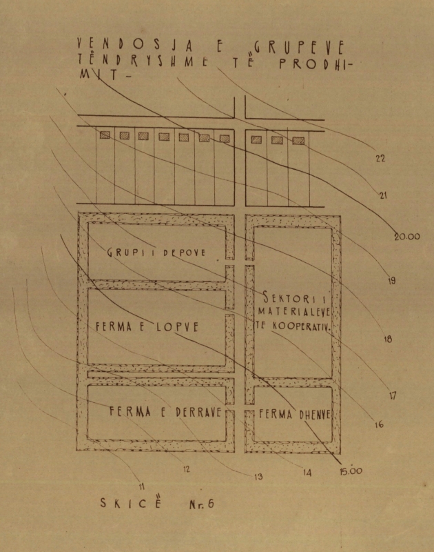
The production zone, including also the auxiliary intermediate
zone, was placed in a favourable position with respect to road
connections and land cultivated with forage, paying attention to
protecting the buildings from wind exposure. It comprised all those
buildings and services intended for intensive farming, the conservation
and storage of agricultural products, and related services aimed at
maximizing the mechanization of the work processes.
This brochure is an important document in reconstructing the
general urban planning legislative excursus in relation to the
socialist rural planning question in Albania. These guidelines
attempted to incorporate the socialist ideology and planning applied to
the peculiar Albanian context, in a period when urban planning was an
“uncertain ground” either as practice or in theory.
Moreover, this document set the beginning of a series of future orders,
decrees, and regulations that will constitute the legislative
references for the study of urban planning evolution in Socialist
Albania and that will culminate in 1978 with the approval of the Decree
of the Presidium of the People's Assembly (DPPA) no. 5747 “For
the drafting, approval, and implementation of masterplans of cities and
villages” and the respective Regulation “For
the drafting and the implementation of masterplans of cities and
villages”, approved by the DCM no. 47, July 10th,
1978 (AQSH 1978a, p. 70, AQSH 1978b, p. 102).
The end of the 1970s coincided also with the split from the
bilateral relation with China and with the consequent harsh
self-isolation of the country. The introductory text of the decree
clearly mirrored this historic moment. It reported that the aim was:
[…] the design and construction of cities and
villages with a socialist content and a national physiognomy, against
any influence of bourgeois and revisionist ideology, for the
concentration and grouping of buildings, saving as much as possible the
agricultural land, and especially the arable land, for [providing] the
solution to current urban planning problems and [giving] perspectives
on the basis of scientific studies [...] (AQSH 1978a, p. 63).
This decree was the first since the beginning of the
dictatorship that tried to clarify where the urban planning
responsibility laid at central and local government levels, overcoming
a prolonged period of professional uncertainty in this field caused by
the inexperience of professionals and authorities, during which
Albanian socialist urban planning was in a confusing situation.
However, despite the above declaration of intent set as a
regime’s priority, the dictatorship mostly considered
architecture and urban planning in rural contexts, secondary to
industrial plans. Generally, in socialist Albania there was a lack of a
real professional and theoretical debate publicly addressed outside of
ideological propaganda. Despite in the second half of the 1970s the
debate around the role of urban planning and architecture started to
gain interest, it remained subordinated to production and economic
purposes in relation to the impellent need to industrialize the country.
Notes
[1]
The date November 10, 1971, corresponded with the celebrations for the
30th anniversary of the founding of the Albanian
Labour Party (ALP).
[2]
The first agricultural cooperative was established on November 11,
1946, in Krutje, near Lushnjë, in the Myzeqe Plain, Central
Albania (Skarço 1987, p.27).
[3]
The maxim “Të bëjmë
fshatin si qytet!”, i.e., Let’s
make the village as a city!, was among the most common ones
used by the ALP propaganda to promote the urbanization of the rural
areas.
[4]
The terminology is borrowed and translated by Soviet literature. Hence,
in the Albanian documents one can read tipizimi
(typification) and projekt-tip (type-design).
[5]
It must also be emphasised that, alongside the increasing evolution of
the disintegration of political and economic relations with the other
states of the Soviet Bloc and China, since the late 1970s the process
of simplification of projects (thjeshtimi
i projekteve) was introduced along the typification with the
aim to save more raw building materials and reduce production and
construction costs.
[6]
See Pompejano F. (2021), “Materialising Modernity
in Rural Socialist Albania”, in A.
Tostões, Y. Yamana (Eds), Proceedings of the 16th Docomomo
2020+1 International Conference, Inheritable Resilience:
Sharing Values of Global Modernities, Tokyo (JP), 29
August-2 September 2021, Vol. 3, 950-955, Docomomo International
& Docomomo Japan, Tokyo Japan, ISBN 987-4-904700-71-6.
[7]
With the creation of the Ndërmarrja Projekti
in 1947, this governing body, supervised by the Ministry of Public
Works, was suppressed. In turn, the Ndërmarrja
Projekti was then suppressed and replaced in 1965 by the Institutit
Shtetëror të Projektimeve (ISP), i.e., the
State Institute of Design. The latter was finally substituted in 1973
by the Instituti i Studimeve dhe i Projektimeve të
Urbanistikës dhe Arkitekturës (ISPUA),
i.e., the Institute for the Study and Design of Urban Planning and
Architecture. Articulated in eight sectors, ISPUA was under the
direction of the Ministry of Construction. At the local level, the Zyrat
e Urbanistikës dhe Projektimit (ZUP), i.e., the
Urban Planning and Design Offices, located in the twenty-six districts,
assisted the ISPUA with the implementation of technical and
methodological tasks.
[8]
The Decision of the Council of Ministers (DCM) no. 2974, October 12th,
1959, “On the drafting, approval, and
implementation of cities and residential centres’ masterplans”
and the complementary Regulation “On the planned
construction of cities and residential centres”
approved with Council of Ministers Decree no. 282, August 16th, 1961,
will be revised in 1970 by the new Minister of Construction, the
engineer Shinasi Dragoti (AQSHb 1970, pp. 1-16).
References
AAVV
(1984) – 40 vjet Shqipëri
socialiste - 40 Years of Socialist Albania. 8
Nëntori, Tirana.
AQSH (1978a) – Decreto del Presidio
dell’Assemblea Popolare n. 5747, 29 giugno 1978
“Për hartimin, miratimin dhe zbatimin e planeve
rregulluese të qyteteve dhe të fshatrave”.
Arkivi Qendror i Shtetit (AQSH), a. 1978, Fondo 490, Cartella 10, 63-70.
AQSH (1978b) – Decreto del Consiglio dei
Ministri n. 47, 10 luglio 1978 “Për miratimin e
Rregullores ‘Për hartimin dhe zbatimin e planeve
rregulluese të qyteteve dhe të
fshatrave’”. Arkivi Qendror i Shtetit
(AQSH), a. 1978, Fondo 490, Cartella 10, 102.
AQSH (1970a) – Lettera n.537, 15 aprile
1970 “Mbi ndertimine shtepive të reja në
fshat”. Arkivi Qendror i Shtetit (AQSH), a. 1970,
Fondo 490, Cartella 364, 1-3.
AQSH (1970b) – Lettera n. Prot. 331, 13
febbraio 1970, “Dërgohen për aprovim
Dekreti dhe Rregullorja e urbanistikës të
ripunuara”. Parashtrese, Arkivi Qendror i Shtetit
(AQSH), a. 1970, Fondo 499, Cartella 48, 1-16.
AQSH (1963) – Istruzioni del Consiglio
dei Ministri “Mbi përcaktimin e vijës
së verdhë të kufijve të fshatrave
në zonat fushore dhe të sektorëve
të NBSH-ve, SMT-ve dhe EDE-ve”. Arkivi
Qendror i Shtetit (AQSH), a. 1963, Fondo 490, Cartella 653.
AQSHa (1961a) – Lettera n. prot. 81/79,
26 giugno 1961, “Mbi ridergimin e project-rregullores
së Urbanistikës”, Parashtrese.
Arkivi Qendror i Shtetit (AQSH), A. 1961, Fondo 490, Cartella 272, 8.
AQSHb (1961b) – Brochure
“Projektimi Urbanistik i Qendrave
Bujqësore”. Arkivi Qendror i Shtetit
(AQSH), a. 1961, Fondo 490, Cartella 272, 64-64/33.
AQSH (1956) – “Raport mbi
planet rregulluese të qyteteve, qendrave industrial dhe
bujqësore dhe masat që duhen marë
për gjëndjen e krijuar”. Arkivi
Qendror i Shtetit (AQSH), A. 1956, Fondo 499, Cartella 461, 29-46.
AQSH (1950) – Report “E kaluara
e fshatarësisë dhe rëndësija e
Reformës Agrare”. Arkivi Qendror i
Shtetit (AQSH), a. 1950, Fondo 498, Cartella 77, 2-5.
AQSH (1947) – Report “Mbi
hartimin e planeve rregulues të katundeve të
rinjë”. Arkivi Qendror i Shtetit (AQSH),
a. 1947, Fondo 498, Cartella 41, 1-16.
BROCHERT J. G. (1975) – “Economic
Development and Population Distribution in Albania”.
Geoforum, Vol. 6, 1975, pp. 177-186.
CZEKALSKI T. (2013) – The shining beacon
of socialism in Europe: The Albanian State and Society in the Period of
Communist Dictatorship 1944-1992. Jagiellonian University
Press, Krakow.
FAJA E., SUKAJ I. e SHEHU A. (1990) – Urbanistika
dhe ndërtimet në fshat. Mimeographed,
Tirana.
GEÇO P. (1973) – La
République Populaire d’Albanie. Tirana.
GUTNOV A., BABUROV A., DJUMENTON G., KHARITONOVA S., LEZAVA I.
e SADOVSKIJ S. (1968) – The Ideal Communist City.
George Braziller Inc., New York.
KOPSIDIS M and IVANOV M. (2018) – Modern
Industry in Southeast Europe 1945-2010: From Rapid Industrialization to
Deindustrialization, Version 1.0, in Online-Handbuch zur
Geschichte Südosteuropas. Band: Wirtschaft und Gesellschaft in
Südosteuropa nach 1800, Leibniz-Institut für Ost-und
Südosteuropaforshung, <https://hgsoe.ios-regensburg.de/fileadmin/doc/texte/Band6/Kopsidis-Ivanov_Industrie_1945-2010.pdf>
INSTITUTI I STUDIMEVE MARKSISTE-LENINISTE (1974) – Vendim
i Plenumit të Komitetit Qendror të PPSH
“Mbi elektrifikimin e krejt fshatrave të vendit deri
më 8 nëntor 1971, me rastin e 30-vjetorit të
themelimit të Partisë”, 12 dhjetor 1967,
in Dokumente Kryesore të Partisë së
Punës të Shqipërisë, Vol. V
(1966-1970), Instituti i Studimeve Marksiste-Leniniste pranë
Komiteti Qendror të PPSH, Tirana, pp. 408-410.
LONDO E. (2022) – Trashëgimia
Socialiste në Peisazhin Rural. Studim
mbi hapësirat publike të ish-fshatrave të
rinj socialiste. Supervisors: Gjergji Islami, Federica
Pompejano. Polytechnic University of Tirana, Faculty of Architecture,
Tirana, Albania (Unpublished MSc Thesis).
MËHILLI E. (2017) – From Stalin
to Mao: Albania and the socialist world. Cornell University
Press, Ithaca.
SKARÇO K. (1987) – Nga
ëndrra për tokën në fshat e
bujqësi të lulëzuar. 8
Nëntori, Tirana.
*Acknowledgments
This article originates from the scientific work conducted by
the author during the implementation of the research project “Materializing Modernity
– Socialist and Post-socialist Rural Legacy in Contemporary
Albania (MaMo)” that has received funding from
the European Union’s Horizon 2020 Research and Innovation
Programme under the Marie Skłodowska-Curie Grant Agreement No. 896925
(https://cordis.europa.eu/project/id/896925).